 |
Testing Ground-Water-Management Alternatives in the Upper Charles River Basin, Eastern MassachusettsFact Sheet 042-03By Leslie DeSimone |
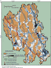
Ground water withdrawn from sand and gravel aquifers provides nearly all of the drinking water for a population of about 100,000 in eight towns in the Upper Charles River Basin (UCRB), which is in Eastern Massachusetts along the Interstate 495 corridor (fig. 1). More than 30 municipal wells withdraw about 10 million gallons per day (Mgal/d) of water from the sand and gravel aquifers (fig. 1). These aquifers are high-yielding, but thin and discontinuous; they occur along the Charles River and its major tributaries and are surrounded by less permeable uplands of bedrock and glacial till. Because ground water in the aquifers and surface water in streams, ponds, and wetlands are closely connected (fig. 2), withdrawals from ground-water wells reduce flow in nearby streams (called "streamflow depletion"), either by capturing water that naturally would discharge to the stream or by drawing stream water into the aquifer. When streamflows are reduced, there may not be enough water to support populations of aquatic life such as fish. Water levels in ponds and wetlands also may be lowered by water withdrawals.
Figure 1. Surficial geology and locations of water withdrawals and wastewater discharges in the Upper Charles River Basin, Eastern Massachusetts.
Population increases of as much as 30 percent in the past decade in some towns resulted in increased water withdrawals and wastewater discharges, which are likely to affect streams and ponds. Water supply and wastewater disposal are managed locally by towns, but their effects on the hydrologic system are regional, because the streams, ponds, and aquifers cross municipal boundaries (fig. 1). To provide tools to evaluate these effects and water-management alternatives, the U.S. Geological Survey, in cooperation with the Massachusetts Departments of Environmental Management and Environmental Protection and the Charles River Watershed Association, developed a computer-based numerical model of the hydrologic system in the basin. The hydrologic model was used to simulate water withdrawals and discharges that occurred during the recent past, to assess the effects on water resources of several hypothetical scenarios of increased withdrawals and altered recharge, and to test the usefulness for balancing water-supply and environmental needs of linking the hydrologic model with optimization techniques--known as simulation-optimization.
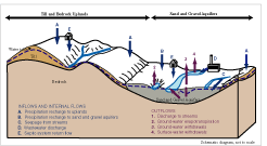
Figure 2. Schematic diagram showing water inflows to and outflows from the hydrologic system in the Upper Charles River Basin. Most withdrawals for municipal supply are from the sand-and-gravel aquifers.
The hydrologic model developed for the UCRB simulates ground-water levels, ground-water flow directions and velocities, and interactions between ground water and surface-water bodies such as streams. The model accounts for all inflows and outflows of water to the aquifers and their associated streams in the basin, including aquifer recharge from precipitation, discharge from septic systems, withdrawals from municipal wells or directly from streams, and wastewater discharges to streams (fig. 2). One component that is not simulated is direct runoff carried by streams during storm events--streamflow in the model is simulated as the component that comes from discharging ground water (the "base flow" component of streamflow), augmented by discharges or depleted by withdrawals. Direct runoff typically is a small component (about 20 percent) of streamflow in the Upper Charles River and its major tributaries.
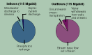
The hydrologic model developed for the UCRB simulates average annual and monthly conditions for 1989-98 ("existing conditions"). It shows that the hydrologic system is dominated by one major inflow, recharge (90 percent), and one major outflow, stream base flow out of the basin (90 percent) (fig. 3). Water withdrawals and wastewater discharges to streams are small, but important, components, each averaging annually about 7 percent of the total flow of water through the simulated hydrologic system.
Figure 3. Major components of the annual water budget for the Upper Charles River Basin, as represented by the hydrologic model. The hydrologic system is dominated by one major inflow, recharge from precipitation, and one major outflow, stream base flow out of the basin.
The effects of increased water withdrawals from streams and ground-water wells that might result from future development were tested in two ways with the hydrologic model:
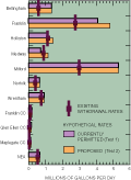
The hypothetical withdrawals are compared with existing withdrawals on an annual average basis in figure 4; withdrawals were increased in the model at each source with monthly variations (greater withdrawals in summer months) that mimic the existing seasonal patterns in the basin. Overall, total withdrawal rates in the basin in the two tests (14.2 to 15.4 Mgal/d) were 42 to 54 percent greater than existing withdrawal rates. Wastewater discharges at treatment facilities and through septic systems also were increased, in accordance with existing water-disposal practices.
Figure 4. Average annual withdrawal rates and current and proposed rates permitted by the Massachusetts Water Management Act for existing conditions and for two tests of increased withdrawals in the Upper Charles River Basin (CC, country club; NEA, Northeast Energy Association).
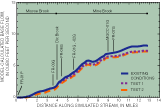
Increased withdrawals led to additional streamflow depletion relative to that simulated for existing conditions in both tests. The flow reductions were generally greatest in late summer and early fall, when streamflow was low and increased withdrawals were large compared to other months of the year. Effects varied in magnitude among tributaries to the Charles River. In the Mine Brook tributary in Franklin, increased withdrawals reduced stream base flow by about 12 percent relative to existing flows along Mine Brook in September (fig. 5). The effects of the two tests were similar along most of the Mine Brook tributary, but differed in its headwaters along Miscoe Brook, where flow downstream of a proposed well (FR-01P, fig. 5) was reduced by as much as 50 percent in test 2. In general, the effects of increased withdrawals were largest where supply wells were located in headwater areas or near small streams, such as Miscoe Brook, Stall Brook, Bellingham (late-summer flow reductions of more than 60 percent), and Miller Brook, Franklin (late summer flow reductions of more than 80 percent) (fig. 1).
Stream base flow was reduced in tributary streams from increased withdrawals whether the withdrawn water was returned to the aquifer after use through septic systems or removed from the tributary subbasin through sewers. The effects were greater and more widespread, however, when sewers removed the water from the subbasin. In sewered areas such as the Mine Brook sub-basin, where wastewater was delivered to a downstream treatment facility, reductions in flow generally equalled the increased withdrawals along the length of the stream. In unsewered subbasins, reductions in stream base flow were a fraction of upstream withdrawals for two reasons. First, septic-system discharge occurred over a wide area, and flowed at least partly to streams far from the withdrawal site. Second, water withdrawn from a well near a stream reduced streamflow almost immediately, but most of the septic-system discharge did not reach the depleted stream until months later.
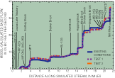
In the Charles River, flow depletions from increased withdrawals were balanced by flow augmentations from wastewater discharge from two treatment facilities in Milford and Medway (stream-miles 4 and 21; fig. 6). Simulated base flow in the Charles River, where it exits the modeled area, increased in September in the two tests, because the wastewater discharges from high summer withdrawals were delivered immediately to the river in summer months, but the flow depletion in the river and its tributaries from the high summer pumping rates took longer to occur. These changes also have implications for water quality in the Charles River. Stream base flow in September was about 90 and 27 percent treated wastewater downstream of the Milford and Medway treatment facilities in these increased-withdrawal tests, as compared with 80 and 18 percent wastewater, respectively, under existing conditions.
Figure 5. Model-calculated average September
base flow along Mine and Miscoe Brooks for existing conditions and for two tests
of increased withdrawals in the Upper Charles River Basin. (Ground-water withdrawals
along the river are indicated asFR-01P, FR-03G, FR-06G, FR-01G, FR-02G, MGCC-01G,
and FR-07G. Identifiers ending in "P" indicate proposed ground-water
withdrawals.)
Figure 6. Model-calculated average September
base flow along the Charles River for existing conditions and for two tests
of increased withdrawals in the Upper Charles River Basin. (Ground- (G) and
surface- (S) water withdrawals along the river are indicated as MF-01S, MF-01G,
MF-02G, MF-03G, MF-04G, MF-05G, BL-12G, MD-01G, MD-03G, FR-08G, and FR-02P;
wastewater discharges are indicated as MTF, Milford Treatment Facility, and
CRPCD, Charles River Pollution Control District Facility in Medway. Identifiers
ending in "P" indicate proposed ground-water withdrawals.)
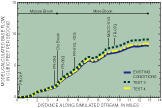
Figure 7. Model-calculated average September
base flow along Mine and Miscoe Brooks for existing conditions and for two tests
of altered recharge in the Upper Charles River Basin. (Ground-water withdrawals
along the river are indicated as FR-01P, FR-03G, FR-01G, FR-02G, FR-06G, MGCC-01G,
and FR-07G. Identifiers ending in "P" indicate proposed ground-water
withdrawals.)
The effects of altered recharge associated with human influence were simulated in the Mine Brook tributary subbasin in Franklin, MA, in two ways:
Results of these tests (fig.7) indicated that the effects of sewering on stream base flow can be substantial, equivalent to an increase in base flow in September of about 12 percent along the length of Mine Brook relative to existing conditions. In contrast, the increase in base flow from recharge of residential rooftop runoff was small, up to about 3 percent relative to existing conditions (fig. 7).
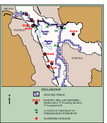
Figure 8. Aquifer area in the Upper Charles River Basin where simulation-optimization methods were applied. (Municipal wells without identifiers were not included in the example optimization problem.)
In simulation-optimization modeling, a numerical hydrologic model is used with optimization techniques to find the "best" way to meet a water-resource goal defined as some quantity to be maximized or minimized. Limitations (constraints) are set on the allowed response of the hydrologic system. Use of these techniques was tested in the UCRB by constructing several hypothetical management problems for a small part of the basin near the confluence of the Charles and Mill Rivers (fig. 8). One management problem quantified how much more water could be withdrawn from the aquifer in this area while maintaining streamflow during the high-demand months of June, July, and August. Constraints were set on the increased withdrawals, by specifying that stream base flow at six constraint locations (fig. 8) had to equal or exceed simulated base flow under existing conditions during summer months.
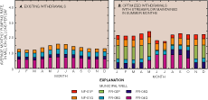
Results suggested that additional water could be withdrawn in this area without decreasing streamflows during the summer months. Under existing conditions, summer pumping rates from all wells averaged 1.55 Mgal/d. By altering pumping schedules and using new wells, summer pumping rates increased by 26 percent to 1.95 Mgal/d (fig. 9). These gains were obtained without decreasing stream base flow during summer months at constraint locations by pumping less in summer from wells close to streams (FR-05G), distributing pumping to new wells (FR-02P and NF-01P), and pumping more in summer from wells distant from streams (FR-04G and NF-01G). Thus, the solution, as determined by simulation-optimization modeling, takes advantage of differences in the response times of streams to pumping at wells distributed throughout the hydrologic system.
Figure 9. Monthly pumping rates for existing conditions and for an example optimization problem where withdrawals at existing (G) and proposed (P) wells are increased but streamflow is maintained during summer months (June through August).
A hydrologic model and simulation-optimization techniques can effectively test scenarios of increased water withdrawals, altered recharge, and other changes in inflows and outflows to the hydrologic system in the Upper Charles River Basin. Effects on stream base flow are demonstrated that provide insight on the connections between ground water, surface water, recharge, withdrawals, and discharges in a developing area. This information and results of similar tests can inform and guide water-management actions by towns, State regulators, and others involved in water-resource management in the basin.

Charles River, Medway, Massachusetts (courtesy of John R. Eggleston)
More information on the Upper Charles River Basin hydrologic model and simulation results can be obtained in:
DeSimone, L.A., Walter, D.A., Eggleston, J.R., and Nimiroski, M.T., 2002, Simulation of ground-water flow and evaluation of water-management alternatives in the Upper Charles River Basin, Eastern Massachusetts: U.S. Geological Survey Water-Resources Investigations Report 02-4234, 94 p.
This report is presented in Portable Document Format (PDF).
To view and print report you will need to use PDF Viewer or Adobe Acrobat Reader (available as freeware).
Users with visual disabilities can visit this site for conversion tools and information to help make PDF files more accessible.
PDF version of report 8 pages (3 MB)
The citation for this report, in USGS format, is as follows:
DeSimone, Leslie A, 2003, Testing Ground-Water Management Alternatives in the Upper Charles River Basin, Eastern Massachusetts: U.S. Geological Survey Fact Sheet 042-03, 8 pages.
For more information about USGS activities in Massachusetts-Rhode Island District, visit the USGS Massachusetts-Rhode Island Home Page.
| AccessibilityFOIAPrivacyPolicies and Notices | |
 |
|