U.S. Geological Survey Fact Sheet 084-02
The text and graphics are presented here in pdf format (print quality) 2.9MB.
Estimates of the magnitude and frequency of flood-peak discharges and flood hydrographs are used for a variety of purposes, such as the design of bridges and culverts, flood-control structures, and flood-plain management. These estimates are often needed at ungaged sites where no observed flood data are available for frequency analysis. Regression equations are commonly used to estimate the magnitude and frequency of flood-peak discharges and flood hydrographs at ungaged sites. These equations are developed by statistically relating the flood characteristics to the physical and climatic characteristics of the watersheds for a group of streamgaging stations within a region that have virtually natural streamflow conditions. Regression equations enable the transfer of flood characteristics from gaged sites to ungaged sites simply by determining the needed watershed and climatic characteristics for the ungaged site.
In 1994, the U.S. Geological Survey (USGS), in cooperation with the Federal Highway Administration and the Federal Emergency Management Agency, released version 1 of the National Flood Frequency (NFF) Program (Jennings and others, 1994). This Microsoft DOS1 program provided engineers and hydrologists a practical tool for computing estimates of flood-peak discharges having recurrence intervals of 2 to 500 years for user-selected sites on rural and urban streams. The 2-year flood occurs, on average, once in 2 years and has a 50 percent chance of occurring in any single year, whereas the 500-year flood occurs, on average, once in 500 years and has a 0.2 percent chance of occurring in any single year.
Version 1 of NFF contained all USGS-developed regional regression equations that were available as of September 1993 for estimating unregulated flood frequencies. NFF also provided the ability to generate flood-frequency plots and plots of typical flood hydrographs corresponding to a given rural and/or urban peak discharge. Since the release of NFF version 1, new or updated equations have been developed by the USGS for most of the Nation. Longer periods of record, and improved methods for measuring basin characteristics and developing regression analyses, have generally led to improved precision of the updated equations over those that they have replaced. The new and updated equations have been compiled and incorporated into a new, easier-to-use, Microsoft Windows1 version of the NFF Program (Ries and Crouse, 2002). Version 3 of the NFF software compiles more than 2,000 flood-flow equations developed by the USGS for 289 regions of the Nation, the Commonwealth of Puerto Rico, and the island of Tutuilla, American Samoa, into a single, user-friendly package. The flood-frequency equations contained in NFF were taken from statewide flood-frequency reports that were prepared generally in cooperation with individual State Departments of Transportation, and/or other government agencies, and were published either by the USGS or the State Departments of Transportation.
Version 3 of NFF can be used to:
NFF can be downloaded from the Internet at the Web address listed at the end of this report. NFF has two components: NFFv3.exe, which is the computer program, and NFFv3.mdb, which is the database. Download each file to the local hard drive by double-clicking on the file names or icons shown in the Web browser window. Next, go to the location of NFFv3.exe on the local hard drive using Windows Explorer or My Computer. Double-click on the file name (NFFv3.exe) to start the NFF Setup Wizard. The Setup Wizard will prompt for a directory name in which to install NFF (typically, C:\Program Files\NFF\), will allow selection of the Start Menu folder in which to place the program’s shortcut, and ask whether or not to create a desktop icon for the program. After all of the selections are completed, click on the Install button to complete the installation. The NFFv3.mdb file must then be copied to the NFF directory when the installation is complete.
NFF can be started by double-clicking on the NFF icon on the desktop or by clicking on the NFF menu item under Programs in the Start menu. A small window will open that allows entry of the user’s name, specification of the NFF work file to which data will be stored, and choice of English or metric units for computation.
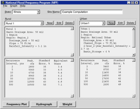
The main NFF user interface window is shown in figure 1. Three pull-down menus at the top of the user interface allow users to (1) open and save work, and create reports for printing, (2) create hydrographs and frequency plots, and (3) access the help file, the NFF Web site, and version information for the program. Just below the pull-down menus are a pair of boxes that allow selection of the State (required) in which the site of interest is located, and naming of the site (optional).
|
| Figure 1. View of the main window of NFF. |
Two large frames — one for rural estimates and the other for urban estimates — fill the center of the main window. A box at the top left of each frame shows the name of the current scenario (a set of estimates for a site). To the right of each box are three buttons, allowing users to (1) create a new scenario, (2) edit the current scenario, or (3) delete the current scenario. Below these buttons are two text boxes. The top box shows input parameters used to evaluate the regression equations for the selected scenario. The bottom box shows the output, including the recurrence intervals, the estimated peak flows, the standard errors of estimate or prediction, and the equivalent years of record for the estimates. The standard errors and the equivalent years of record provide indications of the reliability of the estimates.
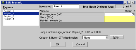
Clicking on either of the New buttons opens the Edit Scenario window (figure 2), which allows users to select the hydrologic region of interest and enter the basin and climatic characteristics needed to evaluate the equations for that region. The scenario name can be specified by typing it into the box at the top of the window, or the program will automatically name the scenario based on the type of scenario (rural or urban) and the number of scenarios that have previously been run. When a region is selected, the names of the basin and climatic characteristics needed to solve the equations for that region are shown in the window. The values are entered in the boxes next to the basin and climatic characteristic names. Placing the cursor over one of these boxes or clicking in a box causes the minimum and maximum values of the basin and climatic characteristics, which were used to develop the equations, to appear in a pop-up text box and in a text line below the list of basin and climatic characteristics. Values outside the ranges shown can be entered, but the resulting peak-flow estimates will be extrapolations with unknown errors.
 |
| Figure 2. View of the Edit Scenario Window. |
Sauer and others (1983) developed regression equations for estimating flood frequencies for urban ungaged sites throughout the United States that are included in NFF. Additional urban equations are available in NFF for several states and municipalities. The urban equations typically use rural estimates for the same site as predictor variables in the urban equations. NFF generates a warning when urban estimates are requested for a site and the rural estimates for the site have not yet been determined.
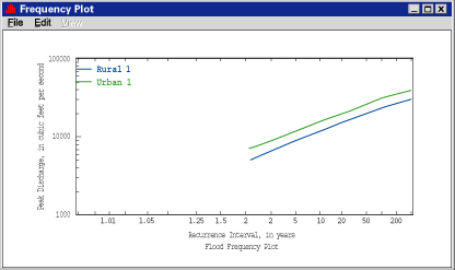
Three buttons at the bottom of the main window access the Frequency Plot, Hydrograph, and Weight options. Clicking on any of these buttons after a rural scenario is created causes another window to open. The Frequency Plot window, allows selection of the plotting scenario. Clicking the plot button causes the selected plotting scenario to be generated in the Frequency Plot window, as shown in figure 3. Pull-down menus allow printing and saving of the plots, modifying of the axes, titles, line styles and legends, listing of the data used to create the plot, and closing of the plot window.
 |
| Figure 3. View of the Frequency Plot Window. |
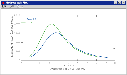
The Hydrograph window allows selection of the scenario and the recurrence interval to be plotted, as well as a lag time. If the scenario is based on the national urban equations (Sauer and others, 1983), the lag time can be estimated by specifying the basin length, in miles. Clicking the Plot button causes a window to open containing the hydrograph plot (figure 4). The pull-down menus provide capabilities including printing, saving, and modifying the axes, titles, line styles and legend of the plot, as well as listing the data used to create the plot, and closing the plot window.
 |
| Figure 4. View of the Hydrograph Plot Window. |
The Weight window can compute weighted estimates for both gaging stations and ungaged sites. A rural scenario of regression estimates must first be obtained for the gaging station before weighted estimates can be obtained. When the Weight window is opened, a button at the top of the window is initially set to calculate weighted estimates for a gaging station. Entering the years of actual record for the gaging station and the peak-flow estimates determined from observed data will cause weighted estimates to be calculated for the gaging station based on the length of years of observed data and the equivalent years of record for the estimates. Clicking on the Apply button saves the weighted estimates as a weighted scenario and places them in the output box of the rural frame in the main NFF window.
To obtain weighted estimates for an ungaged site, first create weighted estimates for the gaging station to be used for estimating peak flows for the ungaged site, then create a rural scenario for the ungaged site. The gaging station must be on the same stream as the ungaged site, and the drainage area for the ungaged site must be within 0.5 and 1.5 times the drainage area for the gaging station for the weighting to be applied. The weighting feature for ungaged sites requires weighted estimates for the nearest gaging station to be used in estimating peak flows, and requires that a scenario for the ungaged site also be created. Then, a rural scenario for the ungaged site must also be created. When the Weight window is open, click on the button at the top right of the window that allows weighting for an ungaged site using weighted gaged values. Select the rural weighted scenario for the gaging station from the pull-down list that will appear in the window, then click on Apply to compute the weighted estimates for the ungaged site and make them appear in the output box of the rural frame in the main NFF window. These weighted estimates for the ungaged site combine the weighted estimates for the gaging station with the regression equation estimates for the ungaged site on the basis of the drainage areas at the gaged and ungaged sites.
The Help file can be accessed through the Help menu at the top of the NFF main window. It provides complete documentation of the technical methods used to estimate peak flows in the software.
The NFF Web site provides links to online reports, fact sheets, and state summaries that document the software and the equations in NFF. Full documentation of the equations and information necessary to solve them is provided in the individual reports for each state. Many of the state reports published since the release of NFF version 1 are available for download from the Web. In addition, fact sheets are available that summarize the reports for 20 states with new or corrected equations developed since the release of NFF version 1. Summaries from the original NFF report (Jennings and others, 1994) are available online for the states that have not developed new equations since the previous software release.
The NFF Web and site and links will be updated as new equations become available. It is recommended that users check these sites periodically to determine whether changes in the software have been made or new equations have been developed for areas of interest that will require obtaining an updated version of the database and new documentation.
Prepared by Craig D. Perl and Kernell G. Ries III
Crippen, J.R., and Bue, C.D., 1977, Maximum floodflows in the conterminous United States: U.S. Geological Survey Water-Supply Paper 1887, 52 p.
Jennings, M.E., Thomas, W.O., and Riggs, H.C., comps., 1994, Nationwide summary of U.S. Geological Survey regional regression equations for estimating magnitude and frequency of floods for ungaged sites, 1993: U.S. Geological Survey Water-Resources Investigations Report 94-4002, 196 p.
Ries, K.G., III, Crouse, M.Y., comps., 2002, The National Flood Frequency Program, Version 3: A computer program for estimating magnitude and frequency of floods for ungaged sites, 2002: U.S. Geological Survey Water-Resources Investigations Report 02-4168, 42 p.
Sauer, V.B., Thomas, WO, Jr., Stricker, V.A., and Wilson, K.V., 1983, Flood characteristics of urban watersheds in the United States: U.S. Geological Survey Water-Supply Paper 2207, 63 p.
For more information contact:
U.S. Geological Survey
Office of Surface Water
415 National Center
Reston, Virginia 20192
(703) 648-5301
USGS hydrologic analysis software is available for electronic retrieval through the World Wide Web (WWW) at http://water.usgs.gov/software/, and through anonymous File Transfer Protocol (FTP) from water.usgs.gov (directory: /pub/software). The WWW page and anonymous FTP directory from which the National Flood-Frequency software and user documentation can be retrieved at http://water.usgs.gov/software/nff.html and /pub/software/surface_water/nff, respectively. NFF software version 3 requires Windows 98/NT Version 4.0 or higher with service pack 5 or higher. For optimal performance, a processor running at 400 megahertz or faster with at least 64 megabytes of memory is recommended. A VGA or better color monitor is also recommended.
Additional earth science information is available from the USGS at http://water.usgs.gov/
or by calling 1-888-ASK-USGS.
| AccessibilityFOIAPrivacyPolicies and Notices | |
 |
|