Reconnaissance geologic investigations by I.L. Tailleur in 1968 noted the presence of widespread iron-oxide staining in creek beds in the Wulik River and Ikalukrok Creek drainages of the western Brooks Range. A brief examination of one of these creeks revealed the presence of weathered sulfide-bearing bedrock and stream sediments containing more than 10 percent lead (Tailleur, 1970). Tailleur named this creek Red Dog Creek, and subsequent exploration in this area resulted in the discovery of the huge Red Dog lead-zinc-silver deposit. As exploration continued in this region, many other metal-bearing deposits were discovered (fig. 1). Today there are at least eight significant areas of high metal concentrations in bedrock at or near the surface in the Wulik River and Ikalukrok Creek areas (fig. 1).
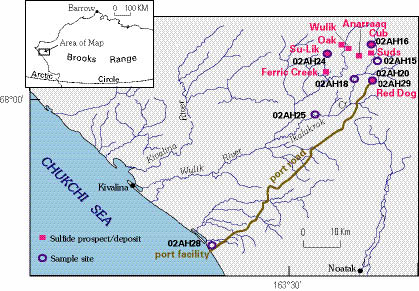
Figure 1. Location map of sulfide mineral deposits and sample sites.
Most of the iron-, lead-, and zinc-bearing rocks in the western Brooks Range originally formed on or immediately below an ancient sea floor about 330 to 340 million years ago (Kelley and others, 2003). The sea floor was at the bottom of a deep-water basin where thin black shale, chert, and carbonate layers were deposited. Metal-bearing fluids deposited minerals such as pyrite (iron sulfide), galena (lead sulfide), and sphalerite (zinc sulfide). These metal-bearing sedimentary rocks are now exposed at the surface and are being eroded and dispersed to the environment along the slopes, creeks, and rivers of the region. Erosion and dispersion of metal-bearing rocks have been ongoing for at least hundreds of thousands of years and have resulted in very large amounts of lead, zinc, and other metals that are now found in the Wulik River and Ikalukrok Creek drainages.
Mining of the Red Dog lead-zinc-silver deposit began in 1989. Ore is mined in an open pit and transferred to a nearby processing facility where it is crushed, ground, and concentrated using a flotation process. The process separates metal-bearing minerals (galena and sphalerite) from other minerals in the metal-bearing host rock. This processing produces a concentrate of fine-grained, clean, and angular galena and sphalerite grains. Trucks are used to transport concentrates from the mine to the coastal port facility where they are temporarily stored during winter. During the summer, concentrates are transferred to barges and then to deep-water ships. Transportation and storage of the concentrate has inadvertently resulted in dispersal of dust from the concentrates along roads, and around the mine and port facility.
High concentrations of lead or zinc in surface materials in northwestern Alaska are of concern to villagers in the region (i.e., Kivalina and Noatak) (fig. 1). It is difficult, however, to determine whether the source is from natural erosion or dispersion or related to fugitive dust, based solely on high concentrations of lead or zinc. This study shows how metal-rich samples that are derived from fugitive concentrate dust can be distinguished from those that are naturally dispersed to the environment by weathering and erosion of metal-bearing deposits.
Natural metal dispersal in the Wulik River and Ikalukrok Creek area effectively started several hundred thousand years ago when glaciers covered the region. These glaciers physically eroded and moved bedrock materials—including parts of metal-bearing deposits in their path—to the limits of glaciation that were at or beyond the present coastline (Coulter and others, 1965). The glaciers eventually melted and retreated to higher parts of the nearby mountains, where remnants were still present until about 11,500 years ago (Hamilton, 1994).
Since the glaciers retreated from the Wulik River and Ikalukrok Creek areas, both physical and chemical weathering processes have continued to disperse metals from bedrock to the environment. Physical weathering breaks up near-surface bedrock and creates a cover of soil and rock fragments as much as several meters thick. Some of these materials, called colluvium, may slowly migrate downslope to valley lowlands where they are then eroded and transported by streams to lower elevations—thus forming alluvium. Both processes—the breaking up of near surface bedrock and deposition of materials in streams—are called mechanical or physical weathering processes. Chemical weathering involves the alteration and dissolution of minerals. Oxidation of sulfide minerals, especially pyrite (iron sulfide), is a very important chemical-weathering process that develops acidic surface materials and waters. The acidic conditions and the abundance of oxidized iron enable further sulfide-mineral breakdown, precipitation of secondary minerals, and dissolution of metals in surface and ground water. Metal-bearing bedrock deposits in the Wulik River and Ikalukrok Creek drainages have been affected by chemical weathering and physical weathering and erosion for at least the last 10,000 years. These are the processes that produced very high (greater than 10 percent) lead concentrations in the sediments of Red Dog Creek before the Red Dog mine existed.
The complicated processes that lead to naturally dispersed metals in the Wulik River and Ikalukrok Creek areas produce several characteristics of the resulting metal-bearing materials that distinguish them from those that are the product of mining-produced fugitive concentrate dust. Naturally dispersed metals can be identified by their patterns of metal concentrations in surface materials, their mineralogic character, and their association with certain other elements.
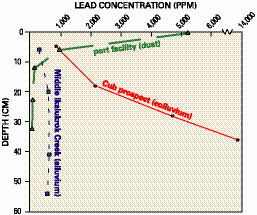
There are two characteristic patterns of metal concentration in natural surface materials of the region. In residual colluvium profiles over metal-bearing bedrock deposits, metal contents characteristically increase with depth and proximity to the metal-bearing bedrock source. The Cub prospect colluvium profile shown in figure 2 illustrates this type of variation. The metal-bearing bedrock at the Cub prospect is on a small tributary to the upper Ikalukrok River, about 9 km upstream from the confluence with Red Dog Creek (fig. 1). The second type of metal-concentration variation is developed in silt, sand, and gravel (alluvium) deposited by streams in the area. In these sediments, metal concentrations remain nearly constant from the surface downward through sampled profiles. Data for the lower Ikalukrok Creek area (fig. 2) illustrate this type of variation. The physical erosion and transport of alluvium by streams effectively mixes and homogenizes metal-bearing material in the alluvium. These two types of metal-concentration variation distinctly contrast with that developed where mining-produced fugitive concentrate dust is the source of high metal concentrations. As one would expect, ore-concentrate dust is localized at the surface, and metal concentrations sharply decrease downward in soil profiles (fig. 2).
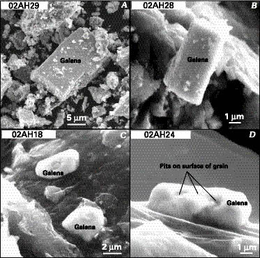
The mineralogic character, including mineral species and the morphology of specific mineral grains, also distinguishes natural metal-rich surface materials. The effects of chemical weathering, especially oxidation, are evident in natural colluvium developed over metal-bearing bedrock. Here, secondary minerals such as jarosite, plumbojarosite, and anglesite are developed; sphalerite is lacking, and galena occurs in only minor amounts, if at all (samples 02AH16, 20, and 24; table 1). Surface materials at the port facility where fugitive concentrate dust is present, contain both galena and sphalerite (02AH28; table 1).
The morphology of galena grains produced by anthropogenic input (mine concentrate and port facility) is different than galena that occurs naturally (alluvium and colluvium over and surrounding natural deposits) (fig. 3). Individual grains of galena and sphalerite in soil at the port facility are angular, and galena shows its characteristic cleavage (fig. 3B) that is similar in appearance to galena from concentrate (fig. 3A). This distinct mineral morphology is to be expected because the concentrate material results from the crushing and grinding of unweathered Red Dog bedrock deposit materials. The preserved sulfide grains in alluvium and colluvium related to natural metal dispersal are very different. Such samples are typically etched and rounded (figs. 3C, 3D). Alluvial sediments contain smooth and well-rounded grains of galena because of the long history of physical weathering and mechanical transport in streams (fig. 3C). Colluvial samples are etched and rounded because they have been chemically weathered in an acidic oxidizing environment (fig. 3D).
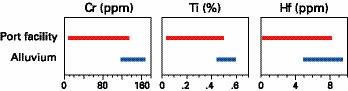
In addition to mineralogy, the overall geochemical character helps distinguish anthropogenic versus natural soils. Some distinguishing geochemical characteristics include:
The Wulik River and Ikalukrok Creek drainages are one of the more metal-rich areas in the world due to natural processes. Geologic processes formed many small to very large metal-rich deposits on or immediately beneath a deep sea floor about 330 to 340 million years ago. One of these deposits, the largest zinc deposit in the world, is now the site of the Red Dog mine. Many of these ancient metal concentrations are now exposed at or near the surface where physical and chemical processes can naturally disperse them to the environment. This natural dispersal of metals, particularly lead and zinc, has occurred widely and in large amounts within the Wulik River and Ikalukrok Creek drainages and has been underway in this area since the onset of glaciation.
The long and complicated history of natural metal dispersal in the Wulik River and Ikalukrok Creek areas developed characteristic metal variations in surface-material profiles, distinctive metal-bearing mineralogic assemblages and morphologies, and certain geochemical characteristics that sharply contrast with those at places where mining-produced fugitive concentrate dust is the source of high metal concentrations. These characteristics can be used to readily distinguish natural metal occurrences from those associated with fugitive concentrate dust.
Coulter, H.W., Pewe, T.L., Hopkins, D.M., Wahrhaftig, C., Karlstom, T.N.V., and Williams, J.R., 1965, Map showing extent of glaciations in Alaska: U.S. Geological Survey Miscellaneous Geologic Investigations Map I-415, scale 1:2,500,000.
Hamilton, T.D., 1994, Late Cenozoic glaciation of Alaska, in Plafker, George, and Berg, H.C., eds., The geology of Alaska: Boulder, Colo., The Geological Society of America, The Geology of North America, v. G-1, p. 813—844.
Kelley, K.D., Leach, D.L., Johnson, C.A., Slack, J.F., Dumoulin, J.A., and King, A.R., 2003, The giant Red Dog Zn-Pb-Ag massive sulfide deposits, northwestern Alaska, USA: Basin setting and conditions of ore formation, in Eliopoulos and others, eds., Mineral exploration and sustainable development: Athens, Greece, Proceedings of the 7th Biennial SGA meeting, 24—28 August 2003, p. 689—692.
Tailleur, I.L., 1970, Lead-, zinc-, and barite-bearing samples from the western Brooks Range, Alaska: U.S. Geological Survey Open-File Report 445, 16 p.
Contacts:
Karen D. Kelley Travis Hudson
USGS MS 964 Applied Geology, Inc
Box 25046 902 Vista del Mar
Denver, CO 80225 Sequim, WA 98382
kdkelley@usgs.gov ageology@olypen.com
Document Accessibility: Adobe Systems Incorporated has information about PDFs and the visually impaired. This information provides tools to help make PDF files accessible. These tools convert Adobe PDF documents into HTML or ASCII text, which then can be read by a number of common screen-reading programs that synthesize text as audible speech. In addition, an accessible version of Acrobat Reader 6.0, which contains support for screen readers, is available. These tools and the accessible reader may be obtained free from Adobe at Adobe Access.
| AccessibilityFOIAPrivacyPolicies and Notices | |
| |
|