Trends in Precipitation and Streamflow in the Fountain Creek Watershed, Southeastern Colorado, 1977-99
Fact Sheet 136–00
by Robert W. Stogner, Sr.
This document also is available in pdf format:![]() FS-136-00.pdf
FS-136-00.pdf
(Requires Adobe
Acrobat Reader)
Table of Contents
How were Changes or Trends in Precipitation and Streamflow Determined?
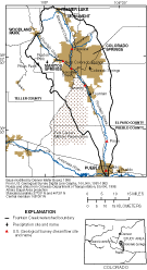 |
| Figure 1. Location of Fountain Creek watershed, precipitation and streamflow sites. |
The Fountain Creek watershed drains about 930 square miles of parts of Teller, El Paso, and Pueblo Counties in southeastern Colorado (fig. 1). Land use within the watershed includes forests, urban areas, military reservations, agriculture, and rangeland. Forested lands are located predominantly in the northwestern mountainous part of the watershed. The major urban center in the watershed is the Colorado Springs metropolitan area that includes Colorado Springs and several smaller communities in El Paso County. Since 1977, population in El Paso County has increased by about 75 percent. As population increased, the amount of impervious area increased. Research has shown that as impervious area increases, infiltration decreases, runoff increases, and a quicker hydrologic response in the receiving streams occurs, which enhances streambank erosion (Goudie, 1986; Douglas, 1983; Dunne and Leopold, 1978). Agriculture and rangeland are located predominantly south of Colorado Springs. Agriculture is common along the alluvial valley from Fountain to Pueblo and relies heavily on water diverted from Fountain Creek. A large expanse of rangeland is included within the boundaries of the military reservation at Fort Carson.
Concerns by landowners, farmers, resource managers, and municipal, county, and local agencies that (1) flooding and associated streambank erosion may be worsening over time, and (2) increases in precipitation, especially during the 1990’s, may be exacerbating the problem, resulted in a study to determine whether precipitation and streamflow in the Fountain Creek watershed has changed over time. The study was done by the U.S. Geological Survey (USGS), in cooperation with the Turkey Creek Soil Conservation District, El Paso County Soil Conservation District, Central Colorado Soil Conservation District, and Pueblo County. Stogner (2000) indicated that no significant trends were detected in precipitation or streamflow prior to 1977. Therefore, this Fact Sheet summarizes trends in precipitation and streamflow from 1977 through 1999. Readers interested in a detailed discussion of trends in precipitation and streamflow for the Fountain Creek watershed from 1939 through 1999 are referred to Stogner (2000).
How were Changes or Trends in Precipitation and Streamflow Determined?
Trends in precipitation and streamflow were determined by compiling precipitation data at four sites and stream- flow data at six sites from 1977 through 1999 (fig. 1). Statistical trend tests were done on daily, seasonal, and annual precipitation data for each site to determine whether precipitation had changed since 1977. To determine whether streamflow had changed since 1977, statistical trend tests were done on several high (annual peak, Q100, Q90, Q70) and low (Q30, Q10, Q0) streamflow statistics computed for each site (table 1). The statistical trend test used was the Kendall test, which provides a probability of precipitation or streamflow to increase or decrease over time. The trend was defined as highly significant if the probability that a trend existed was 99 percent or greater, significant if the probability was between 95 and 99 percent, and moderately significant if the probability was between 90 and 95 percent. No trend was indicated when the probability was less than 90 percent. The Kendall test also provides an estimate of the average annual rate of change.
| Table 1. Description of streamflow statistics used to evaluate trends in streamflow |
|
|
| Streamflow statistic and description |
|
|
|
Annual peak streamflow is the single highest instantaneous recorded streamflow for the water year.¹ 100 percentile (Q100) streamflow is the highest daily mean² streamflow for the water year. 90th percentile (Q90) streamflow indicated 90 percent of the annual daily mean streamflows are below this streamflow or 10 percent are above it. 70th percentile (Q70) streamflow indicates 70 percent of the annual daily mean streamflows are below this streamflow or 30 percent are above it. 30th percentile (Q30) streamflow indicates 30 percent of the annual daily mean streamflows are below this streamflow or 70 percent are above it. 10th percentile (Q10) streamflow indicates 10 percent of the annual daily mean streamflows are below this streamflow or 90 percent are above it. Annual minimum streamflow (Q0) equals the lowest daily mean streamflow for the water year. |
|
|
| ¹A water year extends from October 1 through
September 30 of the following year and is identified by the year in
which it ends. ²Daily mean streamflow is the average of all instantaneous streamflow recordings made each day. |
To determine whether streamflow changed within certain reaches of the watershed, differences in the daily mean streamflow between the upstream and downstream sites within a stream reach were computed. The differences then were divided by the intervening drainage area, resulting in streamflow data normalized to drainage area, and trends were evaluated on the normalized data.
Precipitation is highly variable throughout the watershed; annual precipitation ranges from about 30 inches at the summit of Pikes Peak, an elevation of 14,110 feet, to about 12 inches at Pueblo, an elevation of 4,640 feet.
Depending on location, from 40 to 60 percent of the daily precipitation that occurs is less than or equal to 0.1 inch, and from about 70 to 80 percent of daily precipitation that occurs is less than or equal to 0.25 inch. Daily precipitation of greater than 0.25 inch occurs most frequently from July through September. Many of the precipitation events that occur during this period are associated with thunder storms that generally are strong, localized storms that occur during the late afternoon and early evening. These localized storms frequently result in large variations in annual precipitation over short distances.
During 1977 through 1999, annual precipitation generally was above average, and increasing trends were detected at the Ruxton Park and Pueblo sites. No trends were detected in precipitation at the Colorado Springs and Fountain sites. Additionally, seasonal trend analysis indicated moderately significant increases in spring (AprilJune) precipitation at the Ruxton Park and Pueblo precipitation sites. This analyses indicates that the increasing trends detected in annual precipitation at these sites were likely the result of trends in spring precipitation and were not associated with changes in precipitation that occurred during the summer season or throughout the entire year.
Streamflow in the Fountain Creek watershed varies seasonally and has three distinct flow regimes: base flow, snowmelt, and summer flow. The base-flow period begins in late September or early October and extends until the following April. During the base-flow period, streamflow is fairly uniform. Depending on temperature and winter snowfall amounts, the snowmelt period begins about mid-April and extends until about mid-June. Early in the snowmelt period, streamflow increases substantially from base-flow conditions. Streamflow decreases fairly quickly after peaking in early to mid-May. The summer flow period follows the snowmelt period and generally begins about mid-June and extends through September, sometimes into October. Streamflow during the summer period is highly variable. Changes in streamflow during the summer are primarily affected by afternoon and evening thunderstorms.
A significant increasing trend in annual peak streamflow at the Pikeview site was detected for the post mid-1970’s. No trends were detected in annual peak streamflow at the other five sites during this period. Evaluation of long-term streamflow data at Pueblo (1941–65, 1971–99) indicates instantaneous streamflows of 10,000 cubic feet per second or greater occurred more frequently during the 1990’s than any decade since the 1940’s. Annual peak streamflows during 1994–97 and 1999 ranked in the top 27 percent of all time recorded annual peak streamflows. However, although large stream-flow events occurred more frequently during the 1990’s than during previous decades since the 1940’s, the magnitudes of streamflows that occurred during the 1990’s were not atypical of historical peaks.
Examination of streamflow data and historical accounts of the period indicates that the four largest streamflow events at Pueblo occurred during the spring snowmelt period, mid-April to mid-June. Each of these events were caused by several inches of rainfall that fell during intense storms over large areas of the Fountain Creek watershed. In some areas, rainfall amounts that occurred during these intense storms exceeded the average annual rainfall in the Colorado Springs area. Also significant is that the most recent event, the flood of April 30, 1999, was estimated to be about a 15-year flood for the Pueblo site (Stogner,> 2000). A 15-year flood is a streamflow with a probability of recurring once every 15 years.
Since 1977, highly to moderately significant increasing trends in at
least one high-streamflow statistic were detected at all sites; most sites
had increasing trends in all three daily mean high-streamflow statistics
(Q70, Q90, and Q100). Analysis of changes in streamflow for five stream
reaches also indicated that significant increasing trends in the 70th
percentile (Q70) streamflow statistic occurred in four reaches: Pikeview
to Nevada Street, Near Colorado Springs to Nevada Street, Nevada Street
to Security, and Security to Pinon. No trends in high streamflow were
detected for the reach from Pinon to Pueblo. In
the reach from Nevada Street to Security (fig. 1),
the average annual per-square-mile 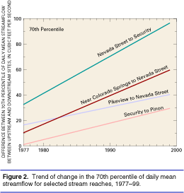 increase
in streamflow for the Q70 and Q90 statistics was about five times greater
than the other reaches that had increasing trends. Additionally, the reach
from Nevada Street to Security showed the greatest annual change in total
streamflow during high flows (fig. 2). This indicates
that, on average, the intervening drainage area for the reach between
Nevada Street and Security contributed more total flow and more flow per
square mile than any of the other drainage areas studied. This
trend probably is attributable to changes in land use from rangeland to
urban that occurred in the intervening drainage area over the past 23
years, which altered the hydrologic response and increased storm runoff.
increase
in streamflow for the Q70 and Q90 statistics was about five times greater
than the other reaches that had increasing trends. Additionally, the reach
from Nevada Street to Security showed the greatest annual change in total
streamflow during high flows (fig. 2). This indicates
that, on average, the intervening drainage area for the reach between
Nevada Street and Security contributed more total flow and more flow per
square mile than any of the other drainage areas studied. This
trend probably is attributable to changes in land use from rangeland to
urban that occurred in the intervening drainage area over the past 23
years, which altered the hydrologic response and increased storm runoff.
The larger frequencies and high significance level of trends detected in the 70th percentile streamflow statistic may indicate that changes in land use within the watershed have increased the rate and magnitude of runoff for more moderate rainfall events that occur more frequently in the watershed than extreme rainfall events that affect the instantaneous peak and annual maximum daily mean streamflows.
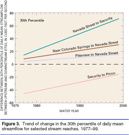
Analysis of low streamflow statistics generally indicates that low streamflows have significantly increased throughout most of the watershed, particularly since the early 1980'. In addition, the average annual rate of increase in the low streamflow statistics have tended to be largest at the sites downstream from Nevada Street. Downstream from Nevada Street, effluent from the Colorado Springs Waste-Water Treatment Plant (WWTP) and several other WWTP's discharge to Fountain Creek. Analysis of changes in streamflow for five stream reaches indicated that significant increasing trends in the 30th percentile (Q30) streamflow statistic occurred in four reaches: Pikeview to Nevada Street, Near Colorado Springs to Nevada Street, Nevada Street to Security, and Security to Pinon. The average annual increase in streamflow for the low streamflow statistics (Q0, Q10, Q30) generally was from 5 to 10 times greater in the reach from Nevada Street to Security than the other reaches that had increasing trends. Additionally, the reach between Nevada Street and Security generally showed the greatest annual change in total streamflow during low flows (fig. 3). The large annual increases in the low streamflows in the reach between Nevada Street and Security have resulted from increased waste-water treatment-plant discharge associated with population growth, importation of transbasin water, and management of the Fountain Creek transbasin return-flow exchange decree, which allows Colorado Springs to exchange return flows from transbasin imports to other locations in the Arkansas River basin.
Douglas, Ian, 1983, The urban environment: Baltimore, Edward Arnold Publishers Ltd., 229 p.
Dunne, Thomas, and Leopold, L.B., 1978, Water in environmental planning: New York,W.H. Freeman and Company, 818 p.
Goudie, Andrew, 1986, The human impact on the natural environment: Cambridge, Mass., The MIT Press, 338 p.
Stogner, R.W., Sr., 2000, Trends in precipitation and streamflow and changes in stream morphology in the Fountain Creek Watershed, 193999: U.S. Geological Survey Water-Resources Investigations 004130, 49 p.
|
For more information, Patrick Edelmann (719) 544-7155, ext. 106 |
