Volcano Hazards Program
The largest eruption on Earth this century occurred at Novarupta Volcano, Alaska, in June 1912, creating Katmai Caldera and the Valley of Ten Thousand Smokes. Volcanic ash (more than from all other historical eruptions in Alaska combined) devastated areas hundreds of miles away. Such massive eruptions will occur again in southern Alaska, threatening its rapidly growing population. To protect the public, U.S. Geological Survey (USGS) and other scientists with the Alaska Volcano Observatory closely monitor the State's many active volcanoes.
On the afternoon of June 6, 1912, an ominous cloud rose into the sky above Mount Katmai on the Alaska Peninsula. The cloud quickly reached an altitude of 20 miles, and within 4 hours, ash from a huge volcanic eruption began to fall on the village of Kodiak, 100 miles to the southeast. By the end of the eruption on June 9th, the ash cloud, now thousands of miles across, shrouded southern Alaska and western Canada, and sulfurous ash was falling on Vancouver, British Columbia, and Seattle, Washington. The next day the cloud passed over Virginia, and by June 17th it reached Algeria in Africa.
During the 3 days of the eruption, darkness and suffocating conditions caused by falling ash and sulfur dioxide gas immobilized the population of Kodiak. Sore eyes and respiratory distress were rampant, and water became undrinkable. Radio communications were totally disrupted, and with visibility near zero, ships couldn't dock. Roofs in Kodiak collapsed under the weight of more than a foot of ash, buildings were wrecked by ash avalanches that rushed down from nearby hillslopes, and other structures burned after being struck by lightning from the ash cloud.
|
|
|
|
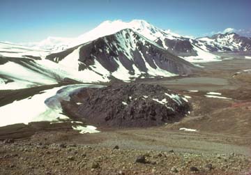
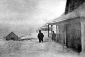
Today, the blocky lava dome of Novarupta sits in the ash-and-debris-filled volcanic crater, more than a mile wide, created by a cataclysmic 1912 volcanic eruption that rained ash over southern Alaska, western Canada, and the Pacific Northwest. Snow-capped Mount Mageik, another potentially explosive volcano in Katmai National Park, can be seen in the background. Photo on right shows a resident of the devastated village of Kodiak, 100 miles southeast of Novarupta, standing in deep drifts of ash shortly after the June 1912 eruption (courtesy National Geographic Society) | |
Similar conditions prevailed elsewhere in southern Alaska, and several villages were abandoned forever. Animal and plant life was decimated by ash and acid rain from the eruption. Bears and other large animals were blinded by ash and starved when large numbers of the plants and small animals they lived on were wiped out. Millions of dead birds that had been blinded and coated by volcanic ash littered the ground. Aquatic organisms, such as mussels, insect larvae, and kelp, as well as the fish that fed upon them, perished in ash-choked shallow water. Alaska's salmon-fishing industry was devastated, especially from 1915 to 1919, because of the starvation and failure of many adult fish to spawn in ash-choked streams.
In 1916, a National Geographic Society expedition led by Robert Griggs visited Mount Katmai and found a 2-mile-wide crater where its summit had been before 1912. Nearby, the expedition discovered a newly formed lava dome they called "Novarupta" and huge flows of volcanic ash filling what they named the "Valley of Ten Thousand Smokes" for the numerous plumes of steam rising from the still-hot ground. Griggs' descriptions of these spectacular features helped persuade President Woodrow Wilson to create Katmai National Monument (now National Park) in 1918.
|
|
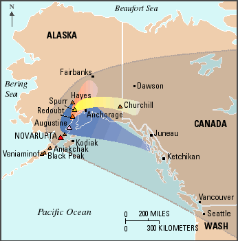
The ash fall from the cataclysmic 1912 eruption of Novarupta (large gray shaded area) dwarfs that produced by recent eruptions of Augustine (blue area), Redoubt (orange area), and Spurr (yellow area) Volcanoes. Old-timers in Alaska can recall dozens of eruptions from these and other Alaskan volcanoes. Within 500 miles of Anchorage, several volcanoes (brown triangles) have exploded in Novarupta-scale eruptions in the past 4,000 years. Beyond the areas shown here, ash fall from these recent eruptions of Augustine, Redoubt, and Spurr Volcanoes was negligible, but ultrafine dust and sulfurous aerosols were held aloft and transported farther by high-altitude winds. Even though relatively small, the volcanic ash clouds from these eruptions still resulted in airport closures and damage to many jet aircraft. Because of the size and frequency of eruptions and prevailing winds, Alaskan volcanoes present a greater threat to aviation on the west coast of the United States than do the volcanoes of the Cascade Range in the Pacific Northwest.
|
In the 1950's, volcanologists discovered that the 1912 eruption was actually from Novarupta, not Mount Katmai. Novarupta's eruption had removed so much molten rock (magma) from beneath Mount Katmai that it caused a cubic mile of Katmai's summit to collapse.
The chance of another Novarupta-scale eruption occurring in any given year is small, but such cataclysmic volcanic events are certain to happen again in Alaska. Within 500 miles of Anchorage, volcanologists have identified at least seven deposits of volcanic ash younger than 4,000 years that approach or exceed the volume of ash ejected by Novarupta in 1912, including a thick layer of ash erupted from Hayes Volcano, only 90 miles northwest of Anchorage. Of the numerous volcanoes scattered across southern Alaska, at least 10 are capable of exploding in a 1912-scale eruption.
|
|
|
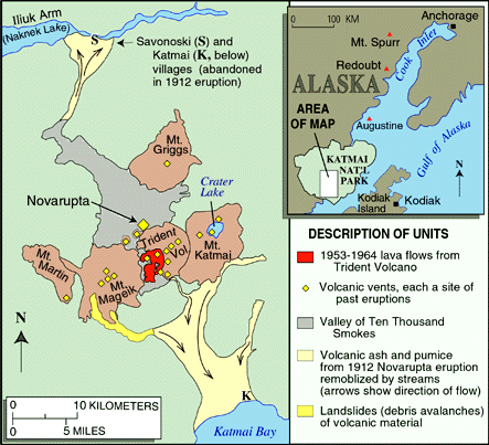
In the 1950's, volcanologists discovered that the great Alaskan eruption of 1912 was not from Mount Katmai, as previously thought, but from a new vent at Novarupta. The eruption removed so much molten rock (magma) from beneath Mount Katmai, however, that a cubic mile of Katmai's summit collapsed to form a 2-mile-wide volcanic depression, called a caldera, which now holds a lake 800 feet deep. Nearby Trident Volcano issued several lava flows (red) and small ash clouds during the decade beginning in 1953. There is no historical record of eruptions at Mageik, Martin, and Griggs Volcanoes, but their vigorous sulfur-rich fumaroles (volcanic gas vents) suggest that they might erupt in the near future. |
When volcanoes erupt explosively, high-speed flows of hot ash (pyroclastic flows) and landslides can devastate areas 10 or more miles away, and huge mudflows of volcanic ash and debris (lahars) can inundate valleys more than 50 miles downstream. Around island volcanoes, like Augustine in Cook Inlet, pyroclastic flows and landslides can generate giant ocean waves (tsunamis) that threaten nearby coastal communities. Explosive eruptions can also produce large earthquakes. In 1912, when Novarupta exploded and Mount Katmai collapsed, 14 quakes of magnitude 6 to 7 rocked the region, and countless smaller shocks occurred. As with Novarupta, however, the greatest hazard posed by eruptions of most Alaskan volcanoes is airborne ash&emdash;even minor amounts of ash can cause the engines of jet aircraft to suddenly fail in flight, create health problems, close roads and airports, disrupt utilities, and contaminate water supplies for hundreds of miles downwind.
In 1912, Alaska was very sparsely populated, and there were few airplanes. Now, nearly three-quarters of a million people live in the State, and aircraft carrying more than 15,000 passengers and millions of dollars in cargo pass near Alaska's more than 40 historically active volcanoes each day.
The heavy ash fall produced by a Novarupta-scale eruption occurring today in southern Alaska would bring the State's economy to a standstill and kill or injure hundreds. Clinics would be overwhelmed by people with eye, throat, and lung damage. Building ventilation systems would have to be closed to outside air. Ash entering computers, bankcard machines, and other electronic equipment would cause them to break down. Automobile, snowmobile, and boat engines would also be damaged. Airports, including Anchorage, which handles the largest amount of air cargo of any airport in the United States and is a refueling stop for many trans-Pacific flights, would be closed until runways could be cleared of ash. To avoid the ash cloud, aircraft would have to be diverted around most of Alaska, Canada, and the Northern United States, seriously disrupting national and international commerce.
|
|
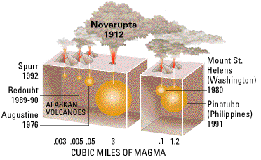
The 1912 eruption of Novarupta was the largest on Earth this century. Explosive eruptions are best compared by recalculating the amount of erupted volcanic materials, such as ash and pumice, in terms of the original volume of molten rock (magma) released (shown diagramatically by orange spheres). On this basis, the 3 cubic miles of magma erupted from Novarupta in 1912 was 600 times greater than the total erupted by Redoubt Volcano in 1989&endash;90 and 30 times greater than the volume of magma released in the 1980 eruption of Mount St. Helens, which killed 57 people and caused damage exceeding 1 billion dollars. Even the 1991 eruption of Mount Pinatubo, the second largest in the world this century, was less than half the size of Novarupta's eruption.
|
Even years later, volcanic ash deposited within 200 miles of the site of the eruption would be remobilized by windstorms and blown high into the atmosphere, renewing the hazards for people and machinery. Fish and wildlife would be devastated as they were after the 1912 eruption, wreaking prolonged havoc on Alaska's now large and economically important fishing and tourism industries.
Promptly restoring normal life would depend heavily on community spirit, civic organization, and pre-eruption planning. By working closely with local authorities, air carriers, and the public, the Alaska Volcano Observatory (AVO), a cooperative effort of the U.S. Geological Survey (USGS), the University of Alaska Fairbanks Geophysical Institute, and the Alaska Division of Geological and Geophysical Surveys, is helping to minimize the effects of volcanic eruptions on Alaskan communities. AVO provides volcano hazards assessments and closely monitors the State's volcanoes for any signs of unrest, so that it can issue timely warnings of impending eruptions.
In addition to active participation in AVO, the ongoing work of the USGS Volcano Hazards Program in other volcanically active regions of the United States, including Hawaii, California, Arizona, Wyoming, and the Pacific Northwest, is helping to better protect people's lives and property from volcano hazards.

![]() U.S. Department of the Interior | U.S. Geological Survey
U.S. Department of the Interior | U.S. Geological Survey
URL: https://pubs.usgs.gov/fs/fs075-98/
Page Contact Information: Michael Diggles
Page Last Modified: July 17, 2009