
U.S. Geological Survey
Fact Sheet 094-02
Online Version 1.0
Coal Underlying Federal Lands in the Gulf of Mexico Coastal Plain
By Alex W. Karlsen, John R. SanFilipo, and Peter D. Warwick
|
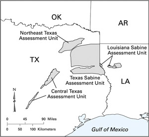
The U.S. Geological Survey (USGS) assessed selected coal beds or coal zones in northeastern Texas, central Texas, and the Sabine Uplift regions of Texas and Louisiana as part of the National Coal Resource Assessment (NCRA). The purposes of the NCRA were (1) to digitally assess original and remaining (unmined) resources for selected coal beds and zones that will be used in the near future, (2) to create publicly available stratigraphic and geochemical data in a geographic information system (GIS) framework, and (3) to provide geologic and geochemical information for the primary coal resources that will supply a major part of the Nation's energy needs during the next few decades. The NCRA was limited to five priority regions; the Texas and Louisiana coals are in the Gulf of Mexico Coastal Plain priority region. |