
U.S. Geological Survey
Fact Sheet 094-02
Online Version 1.0
Coal Underlying Federal Lands in the Gulf of Mexico Coastal Plain
By Alex W. Karlsen, John R. SanFilipo, and Peter D. Warwick
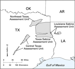
The U.S. Geological Survey (USGS) assessed selected coal beds or coal zones in northeastern Texas, central Texas, and the Sabine Uplift regions of Texas and Louisiana (fig. 1) as part of the National Coal Resource Assessment (NCRA). The purposes of the NCRA were (1) to digitally assess original and remaining (unmined) resources (Wood and others, 1983) for selected coal beds and zones that will be used in the near future, (2) to create publicly available stratigraphic and geochemical data in a geographic information system (GIS) framework, and (3) to provide geologic and geochemical information for the primary coal resources that will supply a major part of the Nation's energy needs during the next few decades. The NCRA was limited to five priority regions; the Texas and Louisiana coals are in the Gulf of Mexico Coastal Plain priority region.
|
Figure 1. Location of coal resource assessment units in the Gulf of Mexico Coastal Plain, one of five regions assessed by the U.S. Geological Survey in the National Coal Resource Assessment. |
The USGS assessment of coal resources in the Gulf of Mexico Coastal Plain was conducted in collaboration with the Louisiana Geological Survey; the University of Texas at Austin, Bureau of Economic Geology; the Railroad Commission of Texas; and the Louisiana Department of Natural Resources, Office of Conservation, Injection and Mining Division.
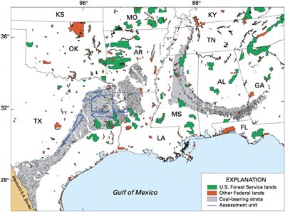
| Figure 2. Distribution of Federal lands (from U.S. Geological Survey, 2000) and outcrop of coal-bearing strata in the Gulf of Mexico Coastal Plain. Blue lines indicate areas assessed for the National Coal Resource Assessment (fig. 1). |
|
At present, there is no systematic inventory of Federal mineral ownership in the central and eastern United States, including the Gulf of Mexico Coastal Plain. Inventories of critical areas are underway by land management agencies. Initial indications are that about half of the Federal surface estate in the Gulf of Mexico Coastal Plain is underlain by federally owned minerals.
Estimated tonnages of coal underlying selected areas of the federally managed surface shown in figure 2 were calculated in a GIS environment by using maps showing the subsurface thickness of selected coal beds or zones. Gross estimates of Federal coal ownership provided by land management agencies were applied to the calculated tonnages to estimate the amount of federally owned coal within these tracts. The estimated coal resource tonnages for the Gulf of Mexico Coastal Plain coal-bearing region do not include coal that underlies Federal lands outside of the areas assessed for the NCRA or coal in the Federal mineral estate that underlies non-Federal surface lands.
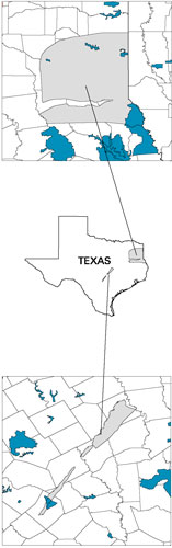
Figure 3 summarizes resource estimates and quality of coals underlying Federal lands within the assessment units of central Texas and the Sabine Uplift area of Texas; these data are from the Gulf of Mexico Coastal Plain Coal Region Assessment Team (in press). The approximately 11 billion short tons estimated to underlie the federally managed surface tracts, including non-Federal coal and surface ownership as outlined above, represents approximately 6.2 percent of the total coal estimated for the Gulf of Mexico Coastal Plain component of the NCRA. Approximately 4.4 billion short tons of this is estimated to underlie federally owned surface, of which approximately 4 billion short tons is federally owned coal. No Federal lands have been identified within the two other Gulf Coast assessment units: the Northeast Texas Assessment Unit and the Louisiana Sabine Assessment Unit.
|
⇐ Figure 3. Maps of the Central Texas and Texas Sabine Assessment Units (gray) and surrounding counties showing the distribution of Federal lands (turquoise). Coal-quality data are given on an as-received basis. Btu/lb, British thermal units per pound. Tonnages are shown to two significant figures; totals in text do not add due to rounding.
Texas Sabine Assessment Unit
Central Texas Assessment Unit |
U.S. Geological Survey, 2000, Federal and Indian lands: Reston, Va., National Atlas of the United States. (Available online at http://www.nationalatlas.gov/fedlandsm.html)
Wood, G.H., Jr., Kehn, T.M., Carter, M.D., and Culbertson, W.C., 1983, Coal resource classification system of the U.S. Geological Survey: U.S. Geological Survey Circular 891, 65 p. (Available online at http://energy. er.usgs.gov/products/papers/C891/index.htm)
For more information on coal underlying Federal lands within the Gulf of Mexico Coastal Plain, please contact:
John R. SanFilipo
U.S. Geological Survey
956 National Center
Reston, VA 20192
Telephone: 703-648-6436
Fax: 703-648-6419
E-mail: jsan@usgs.gov
For more information on the National Coal Resource Assessment, Gulf of Mexico Coastal Plain, please contact:
Peter D. Warwick
U.S. Geological Survey
956 National Center
Reston, VA 20192
Telephone: 703-648-6469
Fax: 703-648-6419
E-mail: pwarwick@usgs.gov
Web: http://energy.er.usgs.gov/ncra/