

|
|
|
U.S. Geological Survey
Fact Sheet 095-02
Online Version 1.0
Vulnerability of U.S. National Parks to Sea-Level Rise and Coastal Change
By E. Robert Thieler, S. Jeffress Williams, and Rebecca Beavers
|
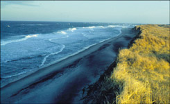
The National Park Service (NPS) manages nearly 12,000 kilometers (7,500 miles) of shorelines along oceans and the Great Lakes. In 2001, the U.S. Geological Survey , in partnership with the NPS Geologic Resources Division, began conducting hazard assessments and creating map products to assist the NPS in managing vulnerable coastal resources.
One of the most important and practical issues in coastal geology is determining the physical response of coastal environments to water-level changes. Two trends may affect shorelines in U.S. national parks: rising global sea level and falling Great Lakes water levels. |
||