
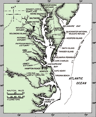
Figure 1. The Mid-Atlantic coast of the United States and the Chesapeake Bay (modified from Ellison and Nichols, 1975). |
The Chesapeake Bay is the largest estuary in the United States and one of the most diverse. It covers approximately 11,400 square kilometers and stretches 332 kilometers from Virginia Beach, Va., to Havre de Grace, Md., at the mouth of the Susquehanna River (fig. 1). Its watershed drains a region of 165,800 square kilometers. The Chesapeake is the shipping artery for Norfolk, Va., and Baltimore, Md., and it is highly valued for its sea life, waterfowl, sport fishing, and recreational boating. At the same time, the bay is threatened by environmental degradation caused by man-induced pollution from a variety of sources. |
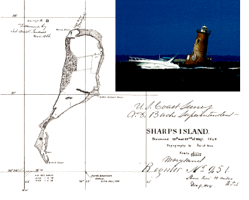
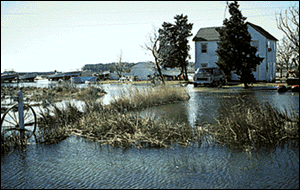
There is little awareness, however, that the rapidly rising relative sea level within the bay is also having dramatic and wide-ranging effects. Islands once populated in colonial time and during the past century have disappeared due to submergence and related shore erosion. The artifacts of early European settlers and prehistoric peoples are sometimes found by watermen working over land areas now covered by the shallow waters of the bay. Sharps Island, described and mapped by John Smith in 1608, has since disappeared, although it was shown on maps and charts as recently as the beginning of the 20th century. Submerged and eroded Sharps Island (fig. 2), formerly at the mouth of the Choptank estuary, is recalled only by a prominent lighthouse erected in 1882 and is now covered by 3- to 4-meter water depths. Expanding wetlands are claiming low-lying communities on Smith Island and Tangier Island. Settlements begun in the 18th and 19th centuries, together with their churches and cemeteries, are often surrounded by the rising water of the bay during periods of extreme high tides -- a prologue to the rising sea level (fig. 3).
|
Figure 2. Map of Sharps Island, showing extent of land mass in 1848 (U.S. Coast Survey, 1848). Inset shows Sharps Island lighthouse, which was built in 1882 (photograph from Vojtech (1997); used with permission from Tidewater Publishers). The former Sharps Island is now submerged, and the lighthouse is surrounded by water 3 to 4 meters deep. |
| Figure 3. Extreme high tide, March 1, 1998, Hoopers Island, Eastern Shore, Md. Photograph by J. Williams. |
|
The Blackwater National Wildlife Refuge, situated on Maryland's Eastern Shore, is unique in its coastal marshland waterfowl habitat. The refuge is being widely affected as steadily rising sea level converts vegetated marshlands into shallow ponds and changes important shallow-water marsh habitat into deeper water plant and animal communities. In short, the bay is changing and changing rapidly, even in human timeframes. With the potential for climate warming in the near future, relative sea-level change could accelerate and bring about even more dramatic change for the bay in the next century.
|
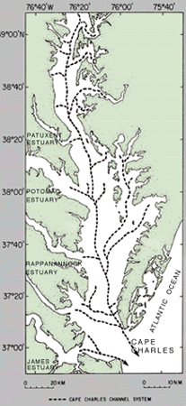
The Chesapeake Bay is the drowned, ancestral valley of the Susquehanna River; the bay is fed by runoff from tributaries of the Potomac, Patuxent, Rappahannock, and James Rivers (fig. 4). About 18,000 years ago, the Susquehanna riverbed extended beyond present Cape Henry and Cape Charles and continued to the shoreline of the Atlantic Ocean, at that time at the edge of the continental shelf. During the last glaciation, ice sheets covered most of Canada and extended southward into the Midwestern United States and eastward into northern New Jersey and along Long Island. Water, once contained in the ocean basins, fell as snow onto the continents, where it was stored as glacier ice. Worldwide sea level fell as glaciers expanded.
At the full extent of the last glaciation, sea level was approximately 100 meters lower than at present, and as a result continental shelves were exposed throughout the world. At the end of the last glacial epoch, sea level rose relatively rapidly as continental glaciers melted. By 15,000 years ago, the outer continental shelves had been submerged, and by 10,000 years ago, the main channel of the ancient Susquehanna River valley was flooded and became a narrow estuary. Between 6,000 and 7,000 years ago, the rate of submergence began to slow, and the Chesapeake Bay took on its characteristic "drowned river valley" shoreline pattern. Sea level at that time stood approximately 9 meters lower than the present level. Since then, the rate of sea-level rise over much of the last 6,000 years has been an almost-imperceptible 1.4 millimeters per year (about 6 inches per century). The present general shoreline configuration was attained by the time the first European and colonial maps were prepared (fig. 5), but as tide gauges and the continued inundation of low-lying areas indicate, relative sea level in the bay is still rising.
Figure 4. Ancestral channel of the Susquehanna River and its tributaries 18,000 years ago at the peak of the last glaciation (modified from Colman and Mixon, 1988). Sea level was about 100 meters below the present level. The Chesapeake Bay is the drowned ancestral valley of the Susquehanna River. NM, nautical miles. |
|
|
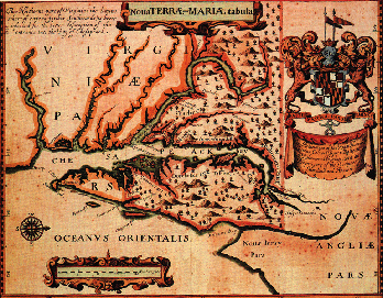
Figure 5. Early colonial map of Maryland and Virginia (from Ogilby, 1671). The map is oriented with north on the right, reflecting its original purpose as a port-finding chart for ship captains approaching the entrance of the Chesapeake Bay. |
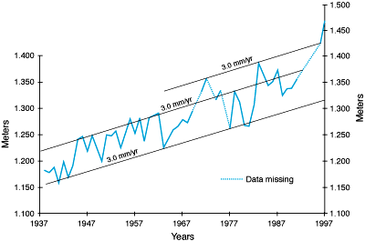
| Figure 6. Annual mean relative sea level recorded at the Solomons Island, Md., tide gauge 1937Ł97 (National Oceanic and Atmospheric Administration, written commun., 1998). |
|
The Chesapeake Bay has also been identified as one of four anomalous areas along the U.S. East Coast that appear tectonically active. A zone of crustal downwarping and sediment accumulation known as the Salisbury embayment has long been recognized beneath the Delmarva Peninsula. It is clearly possible for vertical movement to occur along such zones. Another geologic factor that might account for anomalous rates of sea-level change, at least for the mouth of the bay, is possible subsidence related to compaction of the fill of a large buried impact crater that underlies much of the Norfolk, Hampton Roads, and Cape Charles area. For the Chesapeake Bay, the rate of sea-level rise has certainly accelerated, but just as certainly, rising sea level is the norm in the region rather than the exception. The applied scientific issues in this area revolve around understanding, coping with, and more importantly, planning for an ongoing dynamic Earth process like sea-level change.
One aspect of USGS research is to place in perspective the role of sea-level rise as a natural ongoing process that continues to modify the bay and its resources. Another aspect is to demonstrate the effects of sea level on past and present settlement, as well as environmental change. The Patuxent River was a center of 17th and 18th century settlement and so is a key study site from which to obtain geologic information that can be applied to a variety of societal and scientific problems. Data from sediment cores obtained to document the sea-level history can also furnish records of sedimentation rates, temperature and salinity changes, and water chemistry and can be used to measure human impacts on the natural systems from pre-European settlement times to the modern industrial world. Understanding the history of sea-level rise and associated changes in sedimentation and salinity will help resource managers better formulate and refine restoration strategies for the bay and its resources.
Ellison, R.L., and Nichols, M.M., 1975, Modern and Holocene foraminifera in the Chesapeake Bay region, in Thomas, Charles, and Pelletier, B.R., eds., First International Symposium on Benthonic Foraminifera of Continental Margins; pt. A, Ecology and biology, Maritime sediments: Fredericton, Canada, Atlantic Geoscience Society, p. 131-151.
Ogilby, John, 1671, Noua Terrae-Mariae Tabula, in America -- Being the latest and most accurate description of the New World: London, scale 1:1,470,000. The map is in the Maryland State Archives Special Collections (William T. Snyder Map Collection), map MSA SC 2111-1-2 (downloaded 3/6/98 from the Internet at http://www.mdarchives.state.md.us/msa/homepage/html/ogilbylg.html).
U.S. Coast Survey, 1848, Map of Sharps Island: Adelphi, Md., National Archives and Records Administration, scale 1:20,000.
Vojtech, Pat, 1997, Lighting the bay -- Tales of Chesapeake Bay lighthouses: Centreville, Md., Tidewater Publishers, 208 p.
|
For more information, please contact:
Curtis E. Larsen U.S. Geological Survey |
|
|
955 National Center Reston, VA 20192 |
Telephone: (703) 648Ł6342
E-mail: clarsen@usgs.gov |
|
U.S. Department of the Interior U.S. Geological Survey |
USGS Fact Sheet 102-98 October 1998 |