
In cooperation with the Maryland Geological Survey
Fact Sheet FS-126-97
Evaluation of the Stream-Gaging Network in Maryland, Delaware and Washington, D.C.
INTRODUCTION
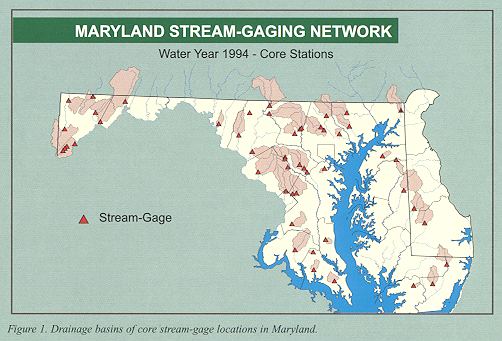
The surface-water discharge data provided by the stream-gaging network in Maryland and surrounding areas (fig.1) are critical to many types of hydrologic and water-quality evaluations. Typical uses of surface-water discharge data in Maryland include (1) regional flood prediction and warning, (2) water-supply evaluation and protection, (3) water-quality evaluation, (4) contaminant-load estimation, and (5) assessment of ecosystem stability and diversity. For all of these purposes, surface-water discharge data must be accurate and available in sufficient detail for the type of analysis being performed,
In order to provide the surface-water discharge data to meet the needs of most types of hydrologic evaluations currently and for the future, a stream-gaging network must be stable for an extended period of time. For most evaluations, discharge data must be available for a period of time that is long enough to account for temporal hydrologic variations. Typically, stream discharge records should be at least 5 years in length (to encompass most variations), and the accuracy of evaluations can be significantly enhanced by record lengths greater than 20 years.
In Maryland, long-term surface-water discharge records are particularly important because of continued changes in the landscape that are caused by man's activities. Ongoing conversion of pervious forest and agricultural land to relatively impervious developed land will cause changes in the hydrologic response of watersheds. These changes can cause the degradation of water quality and stream habitat. To detect the hydrologic effects of land-use changes, long-term discharge records are necessary. If stream-gaging stations with long-term discharge records are discontinued, the State's ability to detect and manage the adverse effects of land-use change will be limited.
To meet the need for surface-water discharge information in Maryland, the stream-gaging network should also represent the full range of geographic conditions. Many current hydrologic studies have been designed to encompass a specific geographic area simply because of the availability of discharge information. For example, sediment or chemical constituent load-estimation studies are often designed where stream-gaging stations already exist to take advantage of historical discharge information (Preston, 1996). Furthermore, retrospective studies of contaminant loading are limited to locations where water-quality data have been collected in association with a stream-gaging station (Langland and others, 1995). These examples illustrate the fact that the stream-gaging network serves as a foundation for many types of data collection and evaluation. In order to facilitate and enhance such studies in the future, the stream-gaging network needs to be designed to be stable for the long term and to be representative of the entire State.
|
This report describes the historical and current stream-gaging network in Maryland and provides some initial results of an evaluation of its adequacy. In particular, the report describes temporal trends in the characteristics of the network and the results of an initial evaluation of its representativeness for the State and surrounding areas. This is not a comprehensive network evaluation, but rather is intended to provide a description of potential network problems and to document the need for more detailed evaluation and planning.
The primary emphasis of this evaluation is the use of stream-gaging stations as a network for evaluating regional hydrologic conditions in Maryland and surrounding areas. Individual stream-gaging stations can be supported to (1) provide site-specific discharge information, or (2) represent large multistate regions. In both of these cases, the stations may have limited value as a component of a statewide network for making evaluations in Maryland. The evaluation was based on the data from a group of stream-gaging stations that represent specific conditions in the State and that can be used to perform statewide or regional evaluations. All work described in this report has been performed by the U.S. Geological Survey in cooperation with the Maryland Geological Survey.
BACKGROUND
The stream-gaging network in Maryland consists of a collection of stations that serve many purposes and are supported by many different agencies. Uses of surface-water discharge information in Maryland have been described by Forest and Walker (1970) and Carpenter and others (1987). Some of these uses include (1) regional hydrologic study, (2) hydrologic system evaluation, (3) meeting legal obligations, (4) planning and design, (5) hydrologic forecasts, and (6) water-quality monitoring. Individual stream-gaging stations are commonly supported for one of these purposes by Federal, State, or local government agencies. However, the station also may be of value as a component of the overall network, particularly for statewide or regional evaluations. Planning of the stream-gaging network for the future requires an awareness of the many sources of support and provisions for loss of funding from any individual agency due to shifting priorities.
The collection of surface-water discharge data began in Maryland and Washington, D.C., in 1892 with the establishment of a stream-gaging station on Rock Creek (Carpenter and others, 1987). The stream-gaging network expanded to 10 stations during the early 1900's when a cooperative program was established between the U.S. Geological Survey (USGS) and the State of Maryland. The cooperative program ended temporarily in 1909, was reinitiated in 1924, and the stream- gaging network was expanded to 28 stations by the early 1930's. The network grew substantially during the 1940's when many local agencies began cooperative programs with the USGS, and by 1950, 87 continuous-record stream-gaging stations were being operated. The network expanded again during the 1960's to a maximum of 117 stations by 1969. That number gradually diminished, however, to 95 stations in 1985. Between 1985 and 1996, the total number of stations remained relatively constant and has ranged between 90 and 95.
Despite the relatively constant number of stream-gaging stations in Maryland, Delaware, and Washington, D.C., there have been significant changes in the composition of the network over the past 10 years. Funding priorities for many agencies have changed during that time; the support for many existing stations has been discontinued while new stations have been established. The effects of these changes on the adequacy of the network for current and future needs is unclear. Due to the changes in support of the network, questions now exist as to whether an adequate number of long-term record stations remain in operation and whether the full range of geographic conditions are represented.
Previous Stream-Gaging Network Evaluations
Past evaluations of the stream-gaging networks have been based on qualitative analysis of the characteristics of individual stations and known uses of the data at those stations. For example, Wahl and Crippen (1984) developed a qualitative rating system based on basin characteristics, data quality, and data use. The system was not applied, but was described for use in network evaluation. Carpenter and others (1987) applied a similar approach that was based primarily on the use of data for selecting stream-gaging stations for possible discontinuation.
Other types of stream-gage network evaluations have concentrated on the statistical adequacy of the network for performing specific types of studies. For example, Dillow (1996) evaluated the potential benefit of including data from new stream-gaging stations for estimating peak discharges. Potential new stations were included in regressions between peak flow and basin characteristics. Changes in the standard errors of the regressions were used as a basis for evaluating the potential benefit of new stations. Estimation of peak flows in areas of Maryland with few existing stream-gaging stations was clearly improved by the addition of new stations.
|
EVALUATION OF THE STREAM-GAGING NETWORK
Definition of a Core Stream-Gaging Network for Regional Hydrologic Study in Maryland
Only a limited number of the stream-gaging stations that are currently being operated in Maryland, Delaware, and Washington, D.C. are appropriate for use in regional hydrologic evaluations. Gaging stations may not be appropriate for use in studies of regional hydrology in Maryland because they (1) do not represent a basin of appropriate size (less than 1 or greater than 300 square miles), (2) a significant amount of the flow at the station is regulated by dams, (3) are on streams from which a significant portion of the flow is withdrawn for municipal or other use, (4) have too short of a record (less than 5 years), or (5) are not located on streams that drain through the State. Stations that meet the appropriate criteria form a "core" stream-gaging network that is composed primarily of hydrologically independent sites that are representative of conditions in Maryland.
Application of the criteria to the set of stream- gaging stations that were being operated in Maryland, Delaware, and Washington D.C., in 1994 results in a set of 51 sites (fig. 1). This set of stations represents a range of conditions that can be used to evaluate the hydrology or water quality of Maryland during 1994. The adequacy of this set of stations for current statewide hydrologic evaluation needs to be determined in order to plan for future studies. Furthermore, the loss (discontinuation) of any of these stations is expected to affect the accuracy of future statewide hydrologic evaluations.
Recent Trends in Numbers of Stream Gages
To meet the needs of statewide hydrologic assessments, the stream-gaging network should include an adequate number of stations to account for hydrologic and geographic variability. The total number of stations should be large enough to account for all significant forms of variability. Furthermore, the number of stations with characteristics appropriate for statewide hydrologic evaluation should be adequate. For example, stations that are appropriate for statewide evaluation should be located on streams that have unregulated flow and that do not have significant withdrawals.
During 1985-96, the total number of stream-gaging stations was nearly constant and ranged from 90 to 95. The constant number of stations during that period implies that support for the stream-gage network has been stable. However, the makeup of the network was quite variable over the period because some stations were discontinued and others were established. The effect of such changes is that the total number of stations is stable; the characteristics of new sites may not be appropriate, however, and there could be a net reduction in the number of stations that are usable for statewide hydrological evaluation.
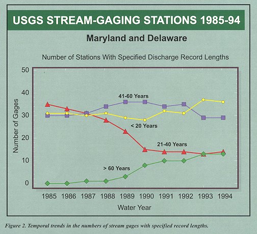
To illustrate the effect of variability in the funding base for the stream-gaging network, the number of stations with four categories of record length was plotted as a function of time (fig. 2). Results indicate that the number of stream-gaging stations with record lengths of less than 20 years and more than 60 years has increased over the past 1 0 years. The increase in the number of stations with less than 20 years of record is due to the start of new stations. These stations may be of limited value at present because of their short record length. The increase in the number of stations with greater than 60 years of record is due to continued operation of older stations and extension of their records beyond 60 years. The continued operation of these long-term stations will provide valuable historical records of streamflow for hydrologic evaluations.
Offsetting the increases in the two categories mentioned above is a substantial decrease in the number of stream-gaging stations with record lengths of between 21 and 40 years. This category of stations is a valuable part of the network because the record lengths are long enough to account for a large amount of hydrologic variability. Loss of such a large number of valuable stations and replacement with newer stations with shorter record lengths could substantially impact the value of the overall network.
|
Representativeness of Current Network
For the current stream-gaging network to be adequate for statewide hydrologic study, it should represent the full range of geographic conditions across the State. The current network needs to be evaluated to determine that the full range of land uses, soil types, topographies, and geologies are included in basins draining to stream-gaging stations. Detailed quantitative evaluation of the representativeness of the network is beyond the scope of this initial study. However, a preliminary evaluation can be performed by qualitatively evaluating the coverage of the network drainage basins on maps of the landscape features in Maryland.
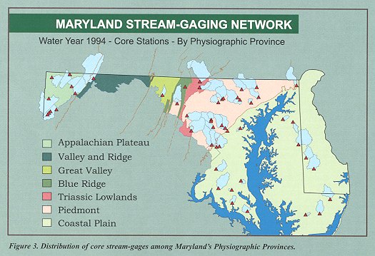
As an example of the approach mentioned above, the stream-gaging network drainage basins were superimposed on a map of the major physiographic provinces in Maryland (fig. 3). This map shows that some physiographic provinces are well represented whereas others are not. The Piedmont Physiographic Province is very well represented in the network and includes pads of 21 gaged drainage basins. The Piedmont includes a large part of the population in Maryland and, as a result, has received more support for hydrologic evaluation. In contrast to the Piedmont, the Valley and Ridge Province is only minimally represented in the stream-gaging network and the Great Valley is represented by only one station. Similary, the western shore and eastern shore Coastal Plain have very limited representation. These areas make up a large pad of the State and are hydrologically distinct from other, better represented areas. For this reason, the small number of stations in the Valley and Ridge, Great Valley and Coastal Plain Physiographic Provinces represents a deficiency in Maryland's stream-gaging network that will affect the adequacy of future hydrologic evaluations.
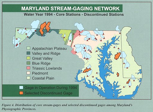
In addition to the reduction of the total number of stream-gaging stations for statewide hydrologic assessment, the loss of stations also has affected the representativeness of the network. Figure 4 is the same map as previously described (fig. 3) in which the gaged drainage basins are super-imposed on the physiography of Maryland. In figure 4, however, six stations that were discontinued since 1970 have been added to the network. Many of the stations that have been discontinued were located in key areas of the State that are unrepresented by the current stream-gaging network. Two stations were discontinued in the Valley and Ridge Province, which is now entirely unrepresented. Four core stations have been discontinued in the Coastal Plain Province, much of which is now unrepresented. Lack of long-term discharge records in these areas is expected to limit the State's ability to perform hydrologic assessments, including assessment of the effects of land-use change.
|
SUMMARY AND CONCLUSIONS
Maryland's stream-gaging network is a critical component of statewide hydrologic evaluation and forms the basis for many types of hydrologic and water-quality studies in the State. In order to meet the need for hydrologic information, the network needs to be designed with statewide evaluation in mind. To achieve that goal, a stable basis of coordination and support is needed from various Federal, State and local government agencies so that long-term, continuous discharge records can be developed for future hydrologic investigations.
This report describes the results of an initial evaluation of the stream-gaging network in Maryland and surrounding areas, and establishes the need for a more detailed evaluation. The report also describes recent trends in the number of stations that make up the network and the representativeness of the network for the State.
Initial evaluation has revealed two deficiencies in the stream-gaging network for Maryland. First, fluctuations in the funding base for the network have resulted in a decreasing trend over the past 10 years for stream-gaging stations with record lengths of between 20 and 40 years. Second, the network does not cover the entire area of the State and one physiographic province is completely unrepresented.
To address these deficiencies, a number of short-term and long-term actions should be performed. In the short term, stream-gaging stations should be re-activated in areas of Maryland that are now unrepresented or significantly underrepresented because stations have been discontinued. In addition, new stream-gaging stations should be established at key locations to improve the geographic coverage of the network. Examples of stations that would address these needs are shown in figure 4. This action will begin to rebuild discharge records that are adequate for hydrologic assessment in those areas. This is important given the ongoing development of most areas of the State, and the need for evaluating the effects of land-use changes in currently ungaged areas.
In the longer term, two actions should be taken. First, a more detailed, quantitative evaluation should be performed to identify other potential deficiencies in the current network. On the basis of results from that study, a core network of stream-gaging stations should be designed that will meet the future needs of the State. Second, Federal, State and local government agencies need to work together to form a stable basis of support for the stream-gaging network. Such support would include (1) the development of an interagency group for coordinating and monitoring the status of the network, and (2) the identification of a stable funding base for the network, Strong support for a well designed stream-gaging network will ensure that future hydrologic studies have adequate historical information to account for all types of variability and in that way provide accurate information to State land- and water-management agencies.
References
- Carpenter, D.H., James, R.W. , and Gillen, D.F., 1987, Cost-effectiveness of the stream-gaging program in Maryland, Delaware, and the District of Columbia: U.S. Geological Survey Water-Resources Investigations Report 87-4093, 85p.
- Dillow, J.J.A. , 1996, Technique for estimating magnitude and frequency of peak flows in Maryland: U.S. Geological Survey Water-Resources Investigations Report 95-4154, 55 p.
- Forest, W.E. and Walker, P.N., 1970, A proposed streamflow data program for Maryland and Delaware: U.S. Geological Survey Open-File Report, 41 p.
- Langland, M.J., Lietman, P.L., and Hoffman, S., 1995, Synthesis of nutrient and sediment data for watersheds within the Chesapeake Bay Drainage Basin: U.S. Geological Survey Water-Resources Investigations Report 95- 4233, 121 p.
- Preston, S.D., 1996, Study of nonpoint-source nutrient loading in the Patuxent River Basin, Maryland. U.S. Geological Survey Water- Resources Investigations Report 96-4273, 6 P.
- Wahl, K.L., and Crippen, J.R, 1984, A pragmatic approach to evaluating a multipurpose stream-gaging network., U.S. Geological Survey Water-Resources Investigations Report 84-4228, 13 p.
Fact Sheet FS-97-126
U.S. Department of the Interior
U.S. Geological Survey
For more information, contact the following:
District Chief
U.S. Geological Survey
8987 Yellow Brick Road
Baltimore, Maryland 21237
Phone: (410) 238-4200 or (888) 826-3130
Internet: http://md.water.usgs.gov/
Maintainer: webmaster@md.water.usgs.gov
