
|
|
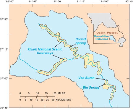
Location of the Ozark National Scenic Riverways in southeast Missouri. U.S. Park Service headquarters are at Van Buren. |
The Ozark National Scenic Riverways contains more than 134 miles of clear spring-fed streams, hundreds of caves, and superb scenery. It is located in a geologically and hydrologically complex area, along the Current and Jacks Fork Rivers, that has received little previous attention from earth scientists. The geology of the area is classified as karst terrain, characterized by dissolution-induced sinkholes, caves, and underground drainage. Bedrock consists mainly of dolomite and lesser amounts of sandstone and chert, interrupted locally by knobs of volcanic rhyolite that form a scenery of picturesque low mountains. The spring system in this area is world class and unparalleled in North America. The Ozark region contains the three largest single-conduit springs in the United States, as well as numerous other major springs, which issue hundreds of millions of gallons of water per day. During peak flow, Big Springs alone produces over 800 million gallons of water per day. The area is truly one of America's natural resource treasures.
|
|
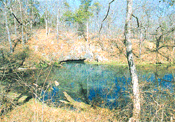
Round Spring. -- This spring is one of the many beautiful springs feeding Current River in the Ozark National Scenic Riverways. It averages over 26 million gallons of water per day and has measured maximum flows of over 300 million gallons per day.
|
The Ozark riverways area lies immediately south of the world's largest lead/zinc mining district -- the Viburnum Trend (Mississippi Valley-type ore deposits) -- and has geologic characteristics similar to those to which Viburnum Trend mineralization is attributed. Federal land in the area has been heavily explored in the past and is presently being explored by mining interests. The National Park Service, U.S. Forest Service, Bureau of Land Management, Nature Conservancy, Missouri Department of Conservation, many environmental groups, and local citizens are all keenly interested in the hydrogeology of the region, especially as it might pertain to potential mining activity.
The goal of GONSR is to produce detailed geologic maps that accurately portray the types and distributions of bedrock formations, as well as the nature and extent of faults. In addition, hydrogeologic features such as springs, seepage, caves, and karst collapse structures are being mapped, and detailed fracture analysis is being emphasized. The maps will aid in understanding ground-water recharge, flow, and discharge and will be valuable in determining the suitability of possible surface sites for mine operations. Existing subsurface data also will be analyzed to portray the regional distributions of aquifers and aquitards and to evaluate possible mineralized areas.
|
|
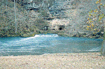
Big Spring. -- This spring produces an average flow of 276 million gallons of water per day and has had measured peak flows of 800 million gallons of water per day. It has been calculated that a daily average of 175 tons of calcium carbonate (CaCO3) is removed from underground in solution through Big Spring. As a result, in one year the total volume of cave openings increases by 30 feet x 50 feet x 1 mile or 7,920,000 cubic feet.
|
Detailed geologic mapping began in the fall of 1995 and is anticipated to continue through the year 2000. During this time, 11 key 7.5-minute quadrangles are targeted for publication. These maps, plus reconnaissance mapping over larger areas, will be incorporated into production of 1:100,000-scale geologic maps of the Spring Valley, West Plains, and Poplar Bluff 30' x 60' quadrangles. Initial results demonstrate the existence of many previously unsuspected faults in the area, as well as pronounced, regionally consistent fracture trends. In addition, mapping is demonstrating the significant role of rhyolites as barriers to ground-water flow through the more permeable dolomites.
For more information, please contact:
Richard Harrison
(703) 648-6928
e-mail: Richard Harrison
Randall Orndorff
(703) 648-4316
e-mail: Randall Orndorff
Robert Weems
(703) 648-6930
e-mail: Robert Weems
U.S. Geological Survey
National Center, MS 926A
Reston, VA 20192