
|
|
|
|
|
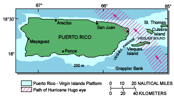
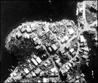
Hurricane Hugo caused considerable economic damage to Puerto Rico.Hugo arrived in mid-September 1989 as a category-four hurricane with sustained winds of 140 miles per hour. The eye of the hurricane passed over the eastern end of the island travelling west-northwest. Hurricane Hugo caused tremendous damage to the infrastructure of eastern Puerto Rico. Over 80 percent of the wooden structures on the islands of Culebra and Vieques were destroyed, and more than 30,000 people were left homeless. Property damage is estimated to exceed $1 billion. Despite the huge losses to infrastructure, the long-term effects of Hugo on the coastal environment are considered to be minimal. Within several months following the hurricane, U.S. Geological Survey (USGS) marine geologists cooperating with Duke University initiated a reconnaissance study to assess the impact of major storm events on coastal resources and coastal environments.
USGS researchers conducted a limited series of field studies following passage of Hugo to evaluate storm effects.Field studies of shoreline erosion and beach recovery were designed to quantify changes in shoreline position along selected portions of the north and east coasts of Puerto Rico using aerial photography taken before and after Hugo. The study documented the impact of Hugo on recreational beaches, particularly in the San Juan area, where historical beach-profile measurements were available. A second field study examined the impact of Hugo on a large offshore sand and gravel deposit, the Escollo de Arenas, a deposit of significant economic potential for Puerto Rico. In a corollary study, USGS scientists investigated the effect of storm events on sediment of the shallow insular shelf in order to assess the amount of nearshore sand and gravel supply and to determine the fate of sand eroded from the shoreline. A fourth study documents the effects of Hugo on coral reef complexes around the island of Culebra. Corals in Puerto Rico and elsewhere are important because the reefs are a source of carbonate sand production, buffers to storm-wave induced coastal erosion, sites of high biologic productivity, as well as tourist attractions. USGS studies indicate that shorelines have recovered to pre-Hugo conditions.Long-term accretionary trends have occurred within embayments between headlands in the San Juan area where there are few engineering structures impinging the coastal zone, whereas slightly erosional trends have occurred at headlands. Thus, USGS scientists have documented the apparent long-term trend of shoreline straightening through headland erosion and embayment infilling. During the passage of Hugo, damage to beaches occurred as a result of elevated water levels through a combination of storm surge, wave setup, and wave swash. The typical beach profile change was one of a general flattening shaped by erosion of the upper beach and deposition on the lower beach. The net effect of Hugo on sandy beaches appeared to be one of beach-face erosion with eroded sediment transported both seaward and landward away from the beach face. In general, the effects of Hugo on sandy beaches in the San Juan area was an erosional perturbation in the seasonal cycle. Post-Hugo changes to beach profiles include a return to nearly pre-Hugo conditions in many localities, though beach recovery has been hampered where engineering structures extending too far seaward were extensively damaged. Preliminary analysis suggested that the largest known offshore sand and gravel deposit was severely affected by Hugo.USGS marine geologists studied aerial photographs of the Escollo de Arenas located off the northwest corner of Vieques Island. Later analysis of closely-spaced high-resolution seismic-reflection profiles, sediment cores, and grab samples taken across the deposit show large-scale changes affecting the volume and overall geometry of the sand and gravel deposit did not occur. In fact, new results indicate that less than 4 percent of the original volume of the Escollo was lost during the passage of Hurricane Hugo.
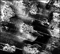
USGS scientists conducted detailed seafloor mapping of selected offshore areas.
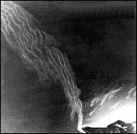
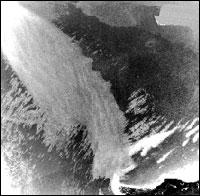
USGS marine geologists examined coral reef complexes around Culebra Island affected by Hurricane Hugo.The shelf area offshore the town of Luquillo was mapped using Divers examined and photographed reefs around Culebra Island, drilled deep cores to determine the geologic history of the reefs, and took cores from individual living corals to study growth rates and to evaluate the effect of Hugo and of previous storms. Reefs on the east and southeast (or windward) sides of Culebra were devastated by Hugo, whereas only minor damage to the coral reefs along the west (or leeward) side of the island was found. In spite of the devastation, the reefs on the east side of Culebra are showing signs of healthy regrowth. The geological evidence suggests that high-energy storms may be necessary for healthy growth of coral reef complexes in the same way fire is necessary for healthy forest growth.
Understanding the ability of coastal environments to recover from effects of storms requires high-quality scientific data.Scientific evaluation of storm effects is only a piece of a complex puzzle linking pre-storm conditions to the process of post-storm recovery. From a geological perspective, hurricanes often accomplish less modification to coastal environments than do other high-energy events because the hurricane passes quickly. This conclusion, however, does not diminish the economic and personal losses to society; it speaks only to the ability of the environment to recover quickly. Geological evidence suggests that sand and gravel resources may be lost as a result of storm action. An understanding of the sediment budget for an area depends on geologists' ability to track movement of sediment and to map the seafloor in detail. For example, early suggestions that sand and gravel off Luquillo were lost off the shelf into the deep ocean during a storm were rejected after detailed mapping indicated that other geological factors intervened. Before such investigations in Puerto Rico, little was known about where sand eroded as a result of storms, where it went, whether it was recoverable, and if damage to the environment was permanent. Detailed mapping in other areas can help to formulate public policy regarding infrastructure rebuilding along the coast, beach replenishment efforts, and future use of marine resources.
|
Related Publications: Coral Reefs in Honduras: Status after Hurricane Mitch - USGS Open File Report 01-133 Puerto Rico Marine Sediments, Terrestrial and Seafloor Imagery, and Tectonic Interpretations - USGS Open File Report 00-006 Related Links: Hurricane Georges - Puerto Rico Post-Storm Aerial Reconnaissance Coral Reefs in Honduras: Status after Hurricane Mitch - Online Mini-Documentary Movie
Tropical Storm Tracks
Duke University National Hurricane Center |
|||||||||||||||||||||