
|
|
|
|
|
Recent industrial and academic concerns have ignited interest in the evolution and history of incised valleys.
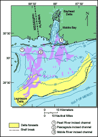
U.S. Geological Survey (USGS) scientists initiated cooperative programs to describe the sedimentary history of the Mississippi-Alabama shelf province.USGS scientists work closely with several State agencies during geologic investigations. The Mobile Bay study is a cooperative project with the Alabama Geological Survey and the Mississippi Office of Geology. Dr. Shea Penland and his colleagues at the Louisiana State University and Dr. Robert Morton and coworkers at the Texas Bureau of Economic Geology have provided significant regional support for studies similar to and west of the Mobile Bay investigations. Other comparable investigations are underway in cooperation with the St. John's River Water Management District in Florida. Similar cooperative studies are underway as part of the SeaGrant Consortium in South Carolina. USGS scientists provide significant capabilities in single-channel seismic surveys, geophysics, vibracoring, and analyzing data to produce a baseline data set that describes the recent geologic history of a region. The geologic history of the Mobile Bay area has been dominated by rapidly changing sea levels over the past several thousand years.
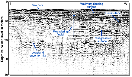
Some 15,000 to 18,000 years ago, sea level was about 300 feet lower than today and the coastline was near the edge of the continental shelf; that is, the abyssal deep was only a short distance offshore. About 6,000 years ago, sea level rose to a level about 15 feet below its present level. Mobile Bay was only a freshwater river, the west Florida coast was about 15 miles further west than its present position, and corals in the Florida Keys began to flourish. Sea level continues to rise, and portions of the Gulf coast are subsiding. In addition, levees on the Mississippi River have reduced the volume of sediment reaching coastal wetlands of the Northern Gulf. The combined effect of human activity and natural forces has caused the loss of barrier islands along the Gulf coast and the consequent loss of wetlands. These losses result in billions of dollars of recreational and commercial value to the affected States. Efforts to mitigate these losses have relied on cooperative USGS studies that described the outcomes of a number of strategies. USGS scientists studying sediment accumulations on the continental shelf have provided new insights to the formation of barrier islands. During the recent geologic history of the Mississippi-Alabama shelf area, river mouths, such as that of the Mobile River, alternately incise and flood as the sea transgressed and regressed because of sea-level changes of as much as 90 feet. Over the past 4,000 years, many of the incised river valleys filled with estuarine muds, while the nearshore marine environment saw the formation of sandy shoals and barrier beaches. As sea level rose, these accumulations of sand migrated shoreward while wave action spread the sand along the shore. During regressions, however, sand bodies move seaward and tend to be covered by muds and other fine sediments of quieter estuarine environments. Such a process of barrier island formation during sea-level changes was poorly understood before USGS and cooperating State scientists interpreted the disparate data available from various workers in the region. USGS studies predict the benefits of shoreline erosion mitigation strategies in the Louisiana coastal wetlands.
The U.S. Corps of Engineers has cut a number of canals across coastal wetlands from the Atchafalaya River to the Gulf initially for navigation but now to provide much-needed sediment to the wetland environment, and to provide sand to naturally maintain existing nearshore barrier islands, possibly helping to slow the erosion of the shoreline. As a result of levee construction along the Mississippi River over the past 150 years, sediment carried by the river was diverted to an area southeast of Lake Pontchartrain where the Mississippi delta has expanded. Relative rapid subsidence of the Mississippi delta area combined with the paucity of new sediments has caused a dramatic loss of wetlands through shoreline erosion. The economic impact of this loss is enormous as wetland habitats such as this one are nurseries for many species of fish and shellfish. The loss of recreational opportunities has placed increased stress on other wetland areas. USGS studies in the Mississippi-Alabama shelf region have immediate application to engineering solutions to shoreline erosion.
|
Related Publications: Geomorphic Classification of Coastal Land Loss between 1932 and 1990 in the Mississippi River Delta Plain, Southeastern Louisiana - USGS Open File Report 00-417 Process Classification of Coastal Land Loss between 1932 and 1990 in the Mississippi River Delta Plain, Southeastern Louisiana
- USGS Open File Report 00-418 National Assessment of Coastal Vulnerability to Sea-Level Rise: Preliminary Results for the U.S. Gulf of Mexico Coast - USGS Open File Report 00-179 Related Links: Mobile Bay Digital Library Alabama Geological Survey Louisiana State University Mississippi Office of Geology U.S. Corps of Engineers |