
|
|
|
|
|
"Contaminants have accumulated in sediments of many coastal environments of the United States, particularly those near major metropolitan centers. U.S. Geological Survey scientists provide information about the distribution, severity, and fate of these contaminated sediments that is essential for making informed management decisions about multiple uses of these coastal environments."
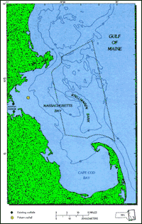
The plan to discharge treated Boston sewage effluent in Massachusetts Bay, instead of in Boston Harbor, has raised concern among citizens and government about contamination of the Bay and adjacent Gulf of Maine.Construction of a new treatment plant and outfall to clean up Boston Harbor is currently one of the world's largest public works projects, costing about $4 billion. There is concern about the long-term impact of contaminants on Massachusetts Bay and adjacent Gulf of Maine because these areas are used extensively for transportation, recreation, fishing, and tourism, as well as waste disposal. Public concern also focuses on Stellwagen Bank, located on the eastern side of Massachusetts Bay, which is an important habitat for endangered whales. Contaminants reach Massachusetts Bay not only from Boston Harbor, but from other coastal communities on the Gulf of Maine, as well as from the atmosphere. Knowledge of the pathways, mechanisms, and rates at which pollutants are transported throughout these coastal environments is needed to address a wide range of management questions.Many contaminants in seawater are associated with particles that become incorporated into sediments. Consequently, U.S. Geological Survey (USGS) studies in the Massachusetts and Cape Cod Bays are designed to provide an understanding of the transport and accumulation of sediments.The studies address such questions as:
USGS studies are an important part of a coordinated effort to understand the environment of the Massachusetts Bay.USGS studies complement and are closely coordinated with a multidisciplinary program supported by the Massachusetts Environmental Trust, the Environmental Protection Agency's Massachusetts Bays Program, and the Massachusetts Water Resources Authority (MWRA). Part of the USGS effort is funded by the MWRA. Studies are conducted cooperatively with scientists at the Woods Hole Oceanographic Institution, the University of New Hampshire, the University of Massachusetts, and the Massachusetts Institute of Technology. Coordination provided by the Massachusetts Bays program ensures that activities are not redundant, and that results are quickly available to managers and other scientists. USGS investigations document the distribution and levels of contaminants in different sediment types across the Bay.Continuing studies are designed to measure changes in contaminant levels in sediments at selected locations. A database of all information on sediment samples in Massachusetts Bay and Boston Harbor is in preparation to provide an inventory of contaminant levels in the sediments. Concentrations of heavy metals near the future outfall site are higher than background concentrations. Elevated concentrations of heavy metal are commonly found in marine areas adjacent to metropolitan centers that have received wastes for a long period of time. Accurate documentation of existing contaminant levels is needed to permit detection of small changes expected with operation of the future outfall. Concentrations of metals, organic pollutants, and sewage contaminants typically are higher near the sediment-water interface than at depth, both in Boston Harbor and at the future outfall site.
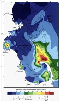
Because contaminants are associated with sediments, sediment maps provide clues to where contaminants may accumulate.USGS sediment maps are used to study sediment processes such as erosion and deposition, to identify the locations where contaminants are likely to accumulate, to improve sediment-transport models by offering verification of expected patterns, and to provide information about the distribution of the seafloor habitats of important commercial fisheries. The maps are also used to select optimal sediment sampling locations for monitoring long-term environmental change. Instrumented moorings provide long-term observations of currents, hydrography, and concentration and composition of suspended matter in western Massachusetts Bay.These observations are essential to investigate the importance of infrequent catastrophic events, such as major storms or hurricanes, for sediment resuspension and transport, and to document seasonal and interannual variability. The long-term oceanographic observations near the outfall also provide an important framework for biological, chemical, and geochemical studies. Understanding the circulation of water in the Bays is critical to determining how nutrients, sediment, contaminants, and other water-borne materials are transported.Circulation in the Bays is driven by winds, tides, and river flow as well as flow in the adjacent Gulf of Maine. Current speed and direction varies over distances of several hundred meters in Boston Harbor and over several kilometers in the Bays. Direct oceanographic measurements provide essential information about the currents in the Bays. However, field measurements cannot adequately resolve these complex circulation patterns and they represent conditions that existed only at the time the measurements were made. Numerical models can help bridge this gap by providing more complete spatial coverage, synthesizing the information from the measurements, and allowing different scenarios to be tested.
Geologic studies are essential for understanding contamination of sediments in coastal regions.The multidisciplinary geologic study of the Massachusetts Bays conducted by the USGS develops techniques that quantify and predict processes of sediment transport and contamination accumulation. These methods can be applied to other coastal areas of the United States. A long-term goal for the USGS is to develop a predictive capability for sediment transport and contaminant accumulation in a variety of coastal environments.
|
Related Publications:
Photographs of the Sea Floor
in Western Massachusetts Bay, Offshore of Boston, Massachusetts,
July, 1999 - USGS Open File Report 00-427
Predicting the Long-Term Fate of Sediments and Contaminants in Massachusetts Bay
- USGS Fact Sheet 172-97
The Legacy of Contaminated Sediments in Boston Harbor
- USGS Fact Sheet Turning Point in Boston Harbor Clean-Up Contaminated-Sediment Database Development and Assessment in Boston Harbor - USGS Fact Sheet 78-99 Related Links: A Geologic Map of the Sea Floor in Western Massachusetts Bay, Constructed from Digital Sidescan-Sonar Images, Photography, and Sediment Samples - U.S. Geological Survey Digital Data Series DDS-3 The Boston Harbor Story Massachusetts Water Resources Authority
Massachusetts Environmental Trust Environmental Protection Agency's Massachusetts Bays Program Woods Hole Oceanographic Institution University of New Hampshire University of Massachusetts Massachusetts Institute of Technology |
|||||||||||||||||