
|
|
|
|
|
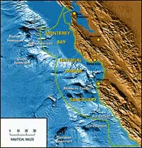
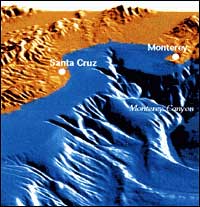
The Monterey Bay Marine Sanctuary is a vast biologic conservatory for which scarce geologic information is known.Monterey Canyon, the most dramatic submarine feature of the sanctuary, rivals the Grand Canyon in relief and topographic complexity. Monterey Canyon ranks among the larger canyons of the world and has a richness of life that exceeds that of most land and marine areas. The marine sanctuary, about 7,500 square kilometers of ocean and seafloor off central California, is home to a rich diversity of marine life. More than 30 species of marine mammals live in or visit the Bay, making it one of the largest collections in the northern hemisphere. For example, Bairds Beaked Whale navigates the canyon to make infrequent surface visits to the Bay. The sanctuary is rich in marine life because nutrient-enriched seawater upwells along the steep margin from deeper, colder waters Monterey Bay Marine Sanctuary is part of an open geological system extending from tens of miles onshore to hundreds of miles offshore.Sediments derived from land accumulate in the marine environment, often at a temporary location awaiting a large storm, strong currents, or a quick shake from an earthquake to send them cascading down the canyon. USGS studies focus on the transport and ultimate fate of sediments entering this environment, as well as on the geologic framework comprising diverse and complex assemblages of faulted and sheared rocks that are representative of the west coast of the United States.
The USGS will establish a Sanctuary corridor of research.USGS research complements the activities of a unique collection of research institutions in the Monterey Bay area. Opportunities abound for cooperative research on the influence of geology in, for example, biological sciences, development of new technologies for deep ocean research, global change, and environmental management. USGS at the Long Marine Laboratory joins UCSC, the National Oceanic and Atmospheric Administration (NOAA), the U.S. Navy, California Department of Fish and Game, California State University, Monterey Bay Aquarium Research Institute, and Stanford University in assembling one of the larger marine sciences communities in the world. USGS scientists expect some surprises as they learn more about the structure and tectonic framework of the sanctuary region.The region is tectonically active, a fact underscored by the 7.0-magnitude Loma Prieta earthquake in 1989. Much has been learned from that event, including indications that the style of faulting may be significantly different than previously thought. Such differences have implications for how rocks move and react to shock waves which, in turn, influence the size of earthquakes. Further studies are needed to determine how these rocks are packaged, how the packages move, and what effect that movement has on the seafloor and adjacent coast. USGS research also focuses on processes shaping the seafloor.Sediments deposited on the shelf are affected by winter storms which resuspend particles and transport them to new locations. For example, giant landslides and currents of turbid materials occur in Monterey Canyon when waves or earthquakes destabilize huge piles of sediment at the head of the canyon. These slides and flows are well documented, but the extent of movement is not well known. Recent mass movements of sediments have moved electronic instruments on the seafloor miles down the canyon. Movement of sediments along the coast and their ultimate accumulation more than 300 kilometers from the shore are topics of study requiring a long-term research commitment.
USGS expects to prepare a "roadmap" of the sanctuary.Side-scan sonar mapping of the nearshore marine environment forms detailed views of the seafloor. While the highly successful GLORIA surveys provide images of the deep ocean much like satellite images of Earth's non-marine surface, higher-resolution images from 30-kHz sonar systems yield images much like aerial photographs. Carefully processed images of the entire marine sanctuary will provide a much-needed roadmap for all the sciences. At the same time, USGS scientists will use knowledge and experience gained in the Monterey Bay Marine Sanctuary to better understand how other active continental margins evolve and how sediment movement might impact other sanctuary regions. More than half the coastline of the Sanctuary is classified as either high-risk or requiring caution.
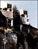
Cliff retreat and storm-wave attack have caused problems in many areas around Monterey Bay and more knowledge of these natural processes in a regional context is important to homeowners, municipalities, and policymakers as mitigation strategies are considered. As cliffs and beaches erode, as wetlands and beaches are degraded by both human and natural processes and become polluted, and as harbors fill with sand and silt, cooperative regional scientific investigations will provide crucial information to minimize unintended effects of human activity. The survival of wetlands, beaches and rocky coastlines depends on the dynamics and balance between erosion and sedimentation and the effects of sea-level changes and tectonic disruption such as earthquakes that are common in the region.
|
Related Publications: Seafloor Rocks and Sediments of the Continental Shelf From Monterey Bay to Point Sur, California
- USGS Miscellaneous Field Studies 2345 Core Descriptions, Core Photographs, Physical Property Logs and Surface Textural Data of Sediment Cores Recovered from the Continental Shelf of the Monterey Bay National Marine Sanctuary During the Research Cruises M-1-95-MB, P-2-95-MB, and P-1-97-MB
- USGS Open File Report 01-107 The Monterey Submarine Canyon, California Moored Array Data Report
- USGS Open File Report 95-838 Related Links: Seafloor Image Map of the Monterey Bay Region Sea-floor Morphology between Año Nuevo and Santa Cruz, California Hydrocarbons Associated with Fluid Venting Process in Monterey Bay, California Monterey Bay Aquarium Monterey Bay Aquarium Research Institute Long Marine Laboratory University of California at Santa Cruz National Oceanic and Atmospheric Administration U.S. Navy California Department of Fish and Game Stanford University |