
U.S. Geological
Survey Fact Sheet 118-00
Online version 1.0
Historically Active Volcanoes in Alaska—A Quick Reference
By
Kristi L. Wallace, Robert G. McGimsey, and Thomas P. Miller
|
ABSTRACT More than 40 active volcanoes occur in Alaska. This report summarizes historical data on those volcanoes, using information drawn from the more thorough and comprehensive U.S. Geological Survey (USGS) Open-File Report 98-582, Catalog of the Historically Active Volcanoes of Alaska. In Alaska, written historical records began about 1760, when Russian sailors and fur traders first explored the southern mainland coast and the Aleutian Islands. Many early accounts of volcanic eruptions are brief and incomplete, and numerous eruptions likely went unreported. Undoubtedly, some accounts mistakenly reported eruptions or misidentified the active volcano. Reports of low-level emission of steam and gas have been omitted. |
 |
|
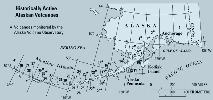
KEY
Number on map—VOLCANO (star next to volcano on map shows volcano monitored by Alaska Volcano Observatory) • Type of volcano • Location (NP, national park; AP, Alaska Peninsula; AI, Aleutian Islands) • Latitude, longitude; highest elevation; vents • USGS 1:250,000 quadrangle map(s) with coverage • Historical activity (record began in 1760; “?” indicates uncertainty) |
1—WRANGELL
• Shield volcano with summit caldera
• 80 km east of Glennallen in Wrangell St. Elias NP
• 62°00’N., 144°01' W.; 4,317 m
• Gulkana, Nebesna, Valdez, McCarthy quads.
• Rare minor steam plumes and phreatic ash
2—SPURR
• Stratovolcano and explosion caldera
• 127 km west of Anchorage
• 61°18’N., 152°15’W.; 3,374 m; 2,309 m, Crater Peak
satellite flank vent (3.5 km south of summit)
• Tyonek quad.
• Jul. 1953, Jun.-Sept. 1992 (Crater Peak)
3—REDOUBT
• Stratovolcano
• 175 km southwest of Anchorage, Aleutian Range in Lake Clark NP
• 60°28’N., 152°45’W.; 3,108 m, 1.5 km-wide, ice-filled
summit crater
• Kenai quad.
• 1902, 1966-68, 1989-90
4—ILIAMNA
• Stratovolcano
• 219 km southwest of Anchorage, Aleutian Range in Lake Clark NP
• 60°02’N., 15304’W.; 3,053 m; ~2,740 m, fu-maroles on east
flank
• Lake Clark quad.
• Intense seismic swarm May and Aug. 1996; fumaroles
5—AUGUSTINE
• Stratovolcano with central dome cluster
• 285 km southwest of Anchorage, Augustine Island, Lower Cook Inlet
• 59°23’N., 153°26’W.; 1,260 m
• Iliamna quad.
• 1812, 1883, 1908?, 1935, 1963-64, 1976, 1986
6—KATMAI
• Stratovolcano with central caldera
• 434 km southwest of Anchorage, AP, Katmai NP
• 58°16’N., 154°59’W.; 2,047 m
• Mt. Katmai quad.
• Jun. 1912
7—NOVARUPTA
• Plinian pyroclastic vent with plug dome
• 442 km southwest of Anchorage, AP, Katmai NP
• 58°16’N., 155°09’W.; 841 m
• Mt. Katmai quad.
• Jun. 1912
8—TRIDENT
• Cluster of 3 stratovolcanoes with a dome complex
• 443 km southwest of Anchorage, AP, Katmai NP
• 58°14’N., 155°07’W.; 1,097 m (elev. of 1953 dome)
• Mt. Katmai quad.
• 1953-74
9—MAGEIK
• Composite volcano
• 452 km southwest of Anchorage, AP, Katmai NP
• 58°11’N., 155°14’W.; 2,165 m
• Mt. Katmai quad.
• 1927?, 1929?, 1936?, 1946?
10—MARTIN
• Stratovolcano and lava flow field
• 458 km southwest of Anchorage, AP, Katmai NP
• 58°10’N., 155°21’W.; 1,860 m
• Mt. Katmai quad.
• 1913-19?, May 1927, Jul. 1951, Feb. 1953, sum-mers of 1953-54?
11—PEULIK
• Stratovolcano with summit and flank domes
• 533 km southwest of Anchorage, AP
• 57°45’ N., 156°21’W.; 1,474 m
• Ugashik quad.
• 1814, 1852
12—UKINREK
MAARS
• Maar
• 532 km southwest of Anchorage, AP
• 57°50’N., 156°30’W.; 91 m
• Ugashik quad.
• Mar.-Apr. 1977
13—CHIGINAGAK
• Stratovolcano
• 610 km southwest of Anchorage, AP
• 57°08’N., 157°00’W.; 2,135 m; 1,600 m, large fumaroles
on north flank
• Ugashik quad.
• 1852?, 1929?, 1971?; fumaroles
14—ANIAKCHAK
• Stratovolcano with summit caldera and intracaldera cones
• 676 km southwest of Anchorage, AP
• 56°53’N., 158°10’W.; 1,341 m, caldera rim; 1,021
m, intracaldera cone
• Chiginik quad.
• 1931
15—VENIAMINOF
• Stratovolcano with summit caldera
• 784 km southwest of Anchorage, AP
• 56°10’N., 159°23’W.; 2,507 m, caldera rim; 2,156
m, intracaldera cone
• Chignik quad.
• 1830-40?, Aug. 4, 1838, 1852, 1874, 1892, 1930, May 23-Jun. 26, 1939,
Nov. 1939, Mar. 28, 1944, Mar-May 1956, Jun. 1983-Apr. 84, 1993-95
16—PAVLOF
• Stratovolcano
• 953 km southwest of Anchorage, southwest AP
• 55°25’N., 161°54’W.; 2,518 m
• Port Moller quad.
• 1790, 1825, 1838, 1844, 1846, 1852?, 1866, 1880, 1886, 1892, 1894, 1906,
1910-11, 1914, 1917, 1922, 1923, 1924, 1929, 1931,1936, 1937, 1942, 1945, 1947,
1948, 1950, 1951, 1953, 1962,1966, 1973, 1974, 1975, 1980, 1981, 1983, Apr.
1986-Aug. 88, Sept. 1996-Jan. 97
17—DUTTON
• Stratovolcano with summit dome complex
• 989 km southwest of Anchorage, southwest tip of AP
• 55°11’N., 162°16' W.; 1,473 m
• Cold Bay quad.
• Intense seismic swarms in 1984 and 1988
18—ISANOTSKI
• Stratovolcano
• 1,086 km southwest of Anchorage, Unimak Island, eastern AI
• 54°45’N., 163°44' W.; 2,446 m
• False Pass quad.
• 1795, 1825, 1830, 1845
19—SHISHALDIN
• Stratovolcano
• 1,098 km southwest of Anchorage, Unimak Island, eastern AI
• 54°45’N., 163°58’W.; 2,857 m
• False Pass quad.
• 1775-78, 1790, 1824-25, 1827-30, 1838, 1842?, 1845 1865, 1880-81, 1883,
1897-99, 1901, 1912, 1922, 1925, 1927-28, May-Jun. 1929, Feb.-May 1932, Aug.
1946-Jan. 47, 1948, Jul. 1955, Dec. 28, 1963, Jan. 28, 1967, Sept.13 (Oct.?),
1975,
Apr.-May 1976, Feb. 8, 1978, Feb. 1979, Mar. 1986-Feb. 87, 1995-96, Apr.-May
1999
20—FISHER
• Stratovolcano with caldera and intracaldera domes
• 1,127 km southwest of Anchorage, Unimak Island, eastern AI
• 54°39’N., 164°26’W.; 1,112 m, caldera rim; 183 m,
caldera lake
• Unimak quad.
• 1795?, 1826?, 1830?
21—WESTDAHL
• Possibly a pyroclastic cone on a truncated ancestral stratovolcano or
shield volcano
• 1,147 km southwest of Anchorage, Unimak Island, eastern AI
• 54°31’N., 164°39' W.; 1,560 m
• Unimak quad.
• 1796, 1820, 1827-30, 1964, Feb. 1978, Feb. 1979, Nov. 1991-mid Jan. 92
22—AKUTAN
• Stratovolcano with caldera
• 1,238 km southwest of Anchorage, Akutan Island, eastern AI
• 54°08’N., 165°58’W.; 1,303 m
• Unimak quad.
• 1790, 1828, 1838, 1845, Mar. 1848, 1852, 1865, 1867, 1883, 1887, 1892,
1896, 1907, 1908, 1911, 1912, 1928, Dec. (May?) 1929, May-Aug. 1931, Dec. 1946-Jan.
47, Apr.-Aug. 1948, Oct. 1951, 1953, Mar.-May 1973, Feb. 11, 1974, Oct. 1976-May
77, Sept.-Oct. 1978, Jul. 1980, Jan.-Mar. 1987, Jun. 1987, Mar.-Apr. 1988, Mar.-May
1992, intense seismic swarm Mar. 1996
23—MAKUSHIN
• Stratovolcano with caldera and parasitic cone
• 1,301 km southwest of Anchorage, Unalaska Island, eastern AI
• 53°53’N., 166°56’W.; 1,800 m
• Unalaska quad.
• 1768-1779, 1790, (1792?), 1802, 1818, Jun 1826, 1827-38, 1845, 1865,
1867, 1883, 1907, 1912, Dec. 1926, Oct. 1938, Dec. 20, 1951, 1952, 1980
24—BOGOSLOF
• Stratovolcano
• 1,349 km southwest of Anchorage, Bogoslof Islands
• 53°56’N., 168°02’W.; 150 m
• Umnak quad.
• May 1796-1804, 1806-23, (1882?) Sept. 1883-95, Mar. 1906-Jan. 07?, Jan.
1907, Sept. 1909-10, Jul. 1926-31?, Sept. 1951, Jul. 1992
25—OKMOK
• Central shield complex with nested caldera
• 1,397 km southwest of Anchorage, Umnak Island, (westernmost of Fox Islands),
eastern AI
• 53°24’N., 168°10’W.; 1,073 m
• Umnak quad.
• 1805, Mar. 1817, 1824-30, 1878, 1899, Mar.-May 1931, 1936, 1938, Jun.
1943, Jun.-Dec. 1945, Aug. 1958, Oct. 1960, Mar. 24, 1981, Jul. 8, 1983, Nov.
1986-Feb. 88, Feb.-Apr. 1997
26—VSEVIDOF
• Stratovolcano
• 1,443 km southwest of Anchorage, Umnak Island (westernmost of Fox Islands),
eastern AI
• 53°08’N., 168°41’N.; 2,149 m
• Umnak quad.
• 1784, May 30, 1790, 1817, 1830, 1878, 1880, Mar. 1957?
27—KAGAMIL
• Stratovolcano
• 1,504 km southwest of Anchorage, Kagamil Island (northeasternmost of
the Islands of Four Mountains)
• 52°58’N., 169°43’W.; 893 m
• Samalga Island quad.
• Dec. 1929, summers 1953-54
28—CARLISLE
• Stratovolcano
• 1,526 km southwest of Anchorage, Carlisle Island (Islands of Four Mountains)
• 52°54' N., 170°03’W.; 1,620 m
• Amukta quad.
• 1774, 1828, 1838, Nov. 1987
29—CLEVELAND
• Stratovolcano
• 1,526 km southwest of Anchorge, Chuginadak Island (Islands of Four Mountains)
• 52°49’N., 169°57’W.; 1,730 m
• Samalga Island quad.
• 1893, 1897, 1929?, Jan. 1932, 1938, Jun. 1944, Nov.-Dec. 1951?, 1975?,
Apr. 28-Jul. 1986, Jun.-Aug. 1987, May 25, 1994
30—YUNASKA
• Shield volcano with caldera and associated stratocones
• 1,573 km southwest of Anchorage, Yunaska Island (Islands of the Four
Mountains)
• 52°38’N., 170°38’W.; 550 m
• Amukta quad.
• 1817, 1824, 1830, 1929?, Nov. 1937
31—AMUKTA
• Stratovolcano
• 1,614 km southwest of Anchorage, Amukta Island (westernmost of the Islands
of Four Mountains)
• 52°30’N., 171°15’W.; 1,066 m
• Amukta quad.
• 1770?, 1786-91, 1876, Feb. 1963, Jul. 1984, Aug.-Sept. 1987, Jul.-Sept.
1996
32—SEQUAM
(PYRE PEAK)
• Stratovolcano within caldera(?)
• 1,689 km southwest of Anchorage, Seguam Island, central AI
• 52°19’N., 172°31’W.; 1,054 m
• Seguam quad.
• 1786-90, 1827, Dec. 1891, spring 1892, 1901?, 1927, Mar. 1977, Dec. 27,
1992, Jul. 31-Aug. 19, 1993
33—KOROVIN
• Stratovolcano
• 1,965 km southwest of Anchorage, Atka Island, central AI
• 52°23’N., 174°09’W.; 1,533 m
• Atka quad.
• 1812 (Kliuchef)?, 1829-30, 1844, 1907?, 1951?, 1953-54?, 1973, 1976?,
May 1986, Mar. 1997, Jun. 1998
34—KASATOCHI
• Stratovolcano
• 1,848 km southwest of Anchorage, Kasatochi Island, central AI
• 52°11’N., 175°30’W.; 314 m
• Atka quad.
• 1760?, 1827, 1828
35—GREAT
SITKIN
• Stratovolcano with caldera and dome
• 1,887 km southwest of Anchorage, Great Sitkin Island, central AI
• 52°05’N., 176°08’W.; 1,740 m
• Adak quad.
• 1792, 1828-29, 1904, Nov. 1933, Mar. 1945, Aug. 1946, 1949-50?, Feb.-Sept.
1974
36—KANAGA
• Stratovolcano with caldera
• 1,951 km southwest of Anchorage, Kanaga Island (Andreanof Islands)
• 51°55’N., 177°10’W.; 1,307 m
• Adak quad.
• 1763?, 1768?, 1786?, 1790?, 1791, 1827, 1829, 1904?-May 06, 1933?, 1993-95
37—TANAGA
• Stratovolcano with two flanking stratocones
• 2,003 km southwest of Anchorage, Tanaga Island (western Andreanof Islands)
• 51°53’N., 178°08’W.; 1,806 m
• Gareloi Island quad.
• 1763-70?, Jun. 7, 1791, 1829, 1914
38—GARELOI
• Stratovolcano
• 2,043 km southwest of Anchorage, Gareloi Island(western Andreanof Islands)
• 51°47’N, 178°48’W; 1,573 m
• Gareloi Island quad.
• 1760, 1790-92, 1828-29, 1873, 1922, 1927, Apr. 1929-30, Aug.-Sept. 1980,
Jan. 1982, Sept. 1987, Aug. 1989
39—CERBERUS
(SEMISOPOCHNOI)
• Stratovolcano with intracaldera cones
• 2,009 km southwest of Anchorage, Semisopochnoi Island (easternmost of
Rat Islands)
• 51°56’N., 179°35’W.; 800 m
• Rat Islands quad.
• 1772, 1790, 1792, 1830, 1873?, Sugarloaf (satellite cone )1987
40—LITTLE
SITKIN
• Stratovolcano with nested calderas
• 1,963 km southwest of Anchorage, Little Sitkin Island (Rat Islands)
• 51°57’N., 178°32’W.; 1,188 m
• Rat Islands quad.
• 1776, 1828-30, 1900?
41—KISKA
• Stratovolcano
• 1,898 km southwest of Anchorage, Kiska Island (westernmost of Rat Islands)
• 52°06’N., 177°36’W.; 1,220 m
• Kiska quad.
• 1907, 1927, Jan. 24, 1962, Mar. 18, 1964, Sept. 11-16, 1969, Apr. 15,
1987?, Jun. 1, 1990
For more
information contact:
Alaska Volcano Observatory
4200 University Dr., Anchorage, AK 99508-4664
Tel. (907) 786-7497 Fax (907) 786-7425
To learn more about Alaska's volcanoes, visit the website
for Alaska Volcano Observatory
Learn more
about volcanoes and the hazards they pose at the
USGS Volcano Hazards Program website
Download this complete fact sheet as a PDF document (164 Kb)
Download a free copy of Adobe Acrobat Reader
See a list
of other volcano-related
fact sheets published by the U.S. Geological Survey
For questions about the content of this report, contact Kristi Wallace
URL of this page:
https://pubs.usgs.gov/fs/2000/fs118-00/
Maintained by: Michael Diggles
Created: September 21, 2000
Last modified: June 3, 2005 (mfd)