Fact Sheet

"The sand and gravel resources of Puerto Rico contribute significantly to the economy of the island as they are crucial ingredients in construction and recreation. Despite newly-imposed regulations prohibiting mining of beach sands, the strength of the associated underground economy is sufficiently strong to limit enforcement of the regulations. Consequently, beaches are eroding quickly causing significant damage to the environment and delicate ecosystems. New resources of sand and gravel would allow beaches to be nourished and construction activities to be supplied."
- Rafael Rodriguez, U.S. Geological Survey
Many of Puerto Rico's beaches are eroding, and though rates of erosion vary, it is a major concern for the tourism and residential development industries. More than 85 percent of the population lives within 7 kilometers of the coast and they are heavily dependent on tourists that are attracted by the island's beaches and coral reefs. High-quality scientific data are needed to help formulate public policy regarding residential and commercial construction along the coast, beach replenishment, and future use of marine resources. Scientists have long recognized that the causes of coastal land loss are not limited to a relative rise in sea level, but can be manmade as well. For example, sediment supply to beaches especially along the north shore of Puerto Rico has been strongly affected by upstream river channeling, dam construction, various agricultural practices, paving and urbanization, as well as shallow-water oceanographic processes. The response to coastal erosion in Puerto Rico has been mostly crisis based leading to engineered solutions that have a negative effect on the coastal environment.
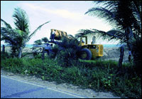
In the 1950's and early 1960's, Puerto Rico enjoyed a construction boom as a part of Operation Bootstrap. Sand and gravel were mined from beaches and rivers, causing damage to the environment in the form of unexpected beach erosion and loss of sources of sand to nourish beaches. Recent studies suggest that Puerto Rico will exhaust its known supplies of onshore sand and gravel by the turn of the century. Thus, offshore resources of sand and gravel for construction and for beach replenishment are of major importance. In the past, unusually high construction costs were somewhat offset by locally available onshore deposits, but these have been largely depleted. Sand and gravel are ubiquitous along coastal areas of Puerto Rico, and their widespread availability has masked the severe economic and environmental penalties of their removal. In 1970, Puerto Rico's Department of Natural Resources (DNR) initiated a cooperative study with the U.S. Geological Survey (USGS) that was designed to identify and describe new resources of sand and gravel on the shelf.
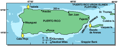 Map showing locations of three submerged sand deposit areas on the insular shelf of Puerto Rico.
Geologists have mapped the shelf of Puerto Rico using seismic-reflection profiling augmented by bottom sampling. Three offshore sand and gravel deposits have been identified which may be economically important. The largest of these, known as Escollo de Arenas, extends off the northwest corner of the island of Vieques, and is estimated to contain 90 million cubic meters of sand and gravel. A second deposit, Cabo Rojo, lies in a shallow trough 1 kilometer offshore near the southwest corner of the main island and is estimated to be nearly as large. The third deposit, Isabela, off the northwest corner of Puerto Rico, may not be economically viable. The geometry and nature of each deposit was determined by seismic surveys, diver-operated Vibracores, surface sampling, and size analysis to determine their suitability for construction use.
Escollo de Arenas extends 6 kilometers northwest from Punta Arenas on the island of Vieques. Its surface shape can be seen clearly from aerial photographs as it varies between 100 and 1,000 meters in width. Sand waves move back and forth as tidal currents sweep over the shoal four times a day at speeds up to 150 centimeters per second. It is these strong tidal currents that anchor the shoal in one place. Geological evidence suggests that the shoal is a "sink" for sand moving west along the north and north along the west coasts of the island. The composition of the sediment is primarily terrigenous nearshore, but becomes increasingly biogenic at the distal end. This evidence suggests that removal of the sand from this shoal should have little effect on the beaches because they are naturally nourished by sand derived from erosion. Other geological evidence suggests that an ancient sand body underlies the shoal, and that the Punta Arenas is actually eroding back from a point about 6 kilometers northwest of its present location.
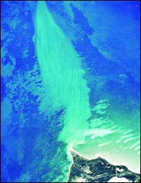 Aerial photograph of the Escollo de Arenas, a subtidal sand and gravel deposit that extends some 6 kilometers north-northwestward of Punta Arenas on the northwest coast of Vieques Island, east of Puerto Rico. Sinuous bedforms extending parallel to the axis of the shoal (and normal to the direction of tidal currents) are sand waves with wavelengths of about 100 meters and amplitudes of 2-3 meters. [larger version]
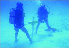 USGS scientists extracting a sediment core from the Escollo de Arenas sand and gravel deposit.
Unlike the Escollo de Arenas, the Cabo Rojo deposit is composed of calcium carbonate materials of biogenic origin, such as shell and coral debris, with very little terrigenous sediment. It is probably a modern isolated deposit in an energy-low trough that collects sediment from longshore transport of materials along Puerto Rico's south coast. Recent DNR studies of cores taken from this deposit indicate that it rests on a layer of fine sediment, such as silts and clays, that would be unsuitable for construction or recreation. The risk to the environment and coral ecosystems by disturbing these fine-grained sediments could make this deposit an expensive resource. The smallest of the three deposits, Isabela, has been discounted as a viable resource. It is not a single, continuous deposit, but is made up of relatively thin lenses of sand spread over a large area in deep water. In addition, the northwest coast of Puerto Rico is a high-energy environment that would hamper recovery of sand and gravel.
Preliminary investigations suggest that other sites have potential to be significant economic resources of sand and gravel. Details of their composition and geometry are not available without careful study. The urgency of the depleting sand and gravel resources of Puerto Rico is underscored by the very high costs associated with building on other nearby islands, such as St. Thomas, where sand and gravel are imported in order to preserve materials for recreational purposes.
Related Publications:
High-Resolution Marine Geologic Maps Showing Sediment Distribution on the Insular Shelf Off Luquillo, Puerto Rico - USGS Open File Report 98-204
USGS Coastal & Marine Geology Program
Related Links:
Hurricane Georges - Puerto Rico Post-Storm Aerial Reconnaissance
USGS Coastal & Marine Geology Program
Puerto Rico Department of Natural and Environmental Resources
Commonwealth of Puerto Rico
|

![]() U.S. Department of the Interior |
U.S. Geological Survey
U.S. Department of the Interior |
U.S. Geological Survey
URL: http://pubsdata.usgs.gov/pubs/fs/sand-gravel/index.html
Page Contact Information: GS Pubs Web Contact
Page Last Modified: Friday, 13-Oct-2017 17:23:01 EDT
