
|
|
|
|
|
"GLORIA mapping has shown that we need to think again about our conventional models for formation of deep-sea fans. Exploration for hydrocarbon accumulations in ancient fan environments may change dramatically as a consequence of our new understanding of deep-sea fan formation." U.S. Geological Survey (USGS) reconnaissance mapping of the Exclusive Economic Zone (EEZ) is nearly complete after 10 years.Acoustic mapping of the EEZ sea floor using GLORIA side-scan sonar tool includes the margins of the continental United States, Alaska, Hawaii, and Johnston Island. This decade-long program was undertaken in cooperation with the United Kingdom's Institute of Oceanographic Sciences at the Deacon Laboratory (now the Southampton Oceanography Centre). USGS scientists have seen several surprising physiographic features on the Gulf of Mexico seafloor.The Mississippi Canyon and DeSoto Canyon are depositional river-like features with levees and meanders, appearing much as rivers do on land; however, these channels formed under as much as 3,200 meters (10,000 feet) of water. Sediment flowed through these channels for hundreds of kilometers before being deposited. Also, the Florida Escarpment is among the world's largest cliffs at as much as 1,800 meters (6,000 feet) high, and erosional features on the escarpment mimic those seen on land. It is significant that these features were formed in the marine environment and were never subject to subaerial process.
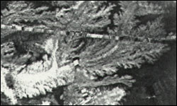
USGS investigations of the Gulf of Mexico seafloor show that patterns of deposition are consistent at several levels of observation.Using GLORIA images, higher-resolution SeaMARC 1A images, and sediment cores, scientists are seeing impressive details of deep-sea fans that have technical interest on two levels. First, patterns of sand deposition in the fans indicate a very slow flow of sediments within restricted paths, as opposed to a flow spread uniformly over large areas in sheets. Second, analyses of cores and SeaMARC images indicate that sand deposition is laterally discontinuous as a result of flow in these channels, rather than laterally continuous as might be expected with sheets of sand. The standard model of deep-sea fan formation is incomplete and, in some important details, incorrect.
Movement of a near-frictionless slurry of sediment and seawater in a narrow, low-relief channel challenges laws of fluid dynamics.The coherent movement of a body of sediment suspended in seawater over a distance of several hundred kilometers and a gradient of about 1 meter per kilometer puzzles USGS scientists. The 'slug' of sediment moves through channels for as much as 600 kilometers before being deposited. Friction between particles in the 'slug' and the underlying channel floor builds slowly enough to allow the material to travel very long distances. The questions raised by this observation may form the basis for a new set of principles of fluid dynamics. Knowledge of the evolution of deep-sea fans is critical to understanding hydrocarbon accumulations.
The Mississippi deep-sea fan is believed to be a modern analogue to certain ancient deep-sea fans that have been extensively drilled for oil and gas accumulations. Links between ancient and modern examples are scarce and weak, largely because good opportunities to study modern analogues have not existed before GLORIA mapping began. New interpretations of the formation of deep-sea fans may provide this necessary link.
|
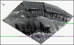
Related Publications: SeaMARC 1A sidescan sonar mosaic, cores and depositional interpretation of the Mississippi Fan:
ArcView GIS Data Release - USGS Open File Report 00-352
Related Links: GLORIA and the EEZ SCAN Program GLORIA Mapping Program - U.S. EEZ Gulf of Mexico Program Southampton Oceanography Centre |