Skip Links

USGS - science for a changing world

General Information Product 155

Prepared in cooperation with the City of Valdosta, Lowndes County, Suwannee River Water Management District, and National Weather Service

Flood-Tracking Chart for the Withlacoochee and Little River Basins in South-Central Georgia and Northern Florida

By Anthony J. Gotvald, Brian E. McCallum, and Jaime A. Painter

Thumbnail of and link to report PDF - Final size is 12 inches x 18 inches designed to be folded to 4 inches x 9 inches (1.24 MB)Summary

The U.S. Geological Survey (USGS), in cooperation with other Federal, State, and local agencies, operates a flood-monitoring system in the Withlacoochee and Little River Basins. This system is a network of automated river stage stations (ten are shown on page 2 of this publication) that transmit stage data through satellite telemetry to the USGS in Atlanta, Georgia and the National Weather Service (NWS) in Peachtree City, Georgia. During floods, the public and emergency response agencies use this information to make decisions about road closures, evacuations, and other public safety issues.

This Withlacoochee and Little River Basins flood-tracking chart can be used by local citizens and emergency response personnel to record the latest river stage and predicted flood-crest information along the Withlacoochee River, Little River, and Okapilco Creek in south-central Georgia and northern Florida. By comparing the current stage (water-surface level above a datum) and predicted flood crest to the recorded peak stages of previous floods, emergency response personnel and residents can make informed decisions concerning the threat to life and property.

First posted January 31, 2014

  • Report PDF (1.24 MB)
    Final size is 12 inches x 18 inches designed to be folded to 4 inches x 9 inches.

For additional information, contact:
Director, Georgia Water Science Center
U.S. Geological Survey
1770 Corporate Drive
Suite 500
Norcross, GA 30093
http://ga.water.usgs.gov

Part or all of this report is presented in Portable Document Format (PDF). For best results viewing and printing PDF documents, it is recommended that you download the documents to your computer and open them with Adobe Reader. PDF documents opened from your browser may not display or print as intended. Download the latest version of Adobe Reader, free of charge.


Suggested citation:

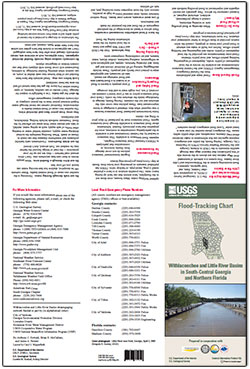
Gotvald, A.J., McCallum, B.E., and Painter, J.A., 2014, Flood-tracking chart for the Withlacoochee and Little River Basins in south-central Georgia and northern Florida: U.S. Geological Survey General Information Product, 2 p., https://dx.doi.org/10.3133/gip155.

ISSN 2332-3531 (print)

ISSN 2332-354X (online)


Accessibility FOIA Privacy Policies and Notices

Take Pride in America logo USA.gov logo U.S. Department of the Interior | U.S. Geological Survey
URL: http://pubsdata.usgs.gov/pubs/gip/0155/index.html
Page Contact Information: GS Pubs Web Contact
Page Last Modified: Wednesday, 30-Nov-2016 12:23:13 EST