Skip Links

USGS - science for a changing world

General Information Product 124

Lidar Postcards

By Heather A. Schreppel and Matthew J. Cimitile

Description

The U.S. Geological Survey (USGS) Coastal and Marine Geology Program develops and uses specialized technology to build high-resolution topographic and habitat maps. High-resolution maps of topography, bathymetry, and habitat describe important features affected by coastal-management decisions. The mapped information serves as a baseline for evaluating resources and tracking the effectiveness of resource- and conservation-management decisions. These data products are critical to researchers, decision makers, resource managers, planners, and the public. To learn more about Lidar (light detection and ranging) technology visit: http://ngom.usgs.gov/dsp/.


Thumbnail image of Postcard Thumbnail image of Postcard

First posted March 15, 2011

For additional informtion contact:
Heather Schreppel
St. Petersburg Coastal and Marine Science Center
600 4th Street South
St. Petersburgh, FL 33701
http://coastal.er.usgs.gov/

Part or all of this report is presented in Portable Document Format (PDF); the latest version of Adobe Reader or similar software is required to view it. Download the latest version of Adobe Reader, free of charge.


Suggested citation:

Schreppel, H.A., and Cimitile, M.J., 2011, Lidar postcards: U.S. Geological Survey General Information Product 124, 4 p.


Contents

The four postcards are as follows:

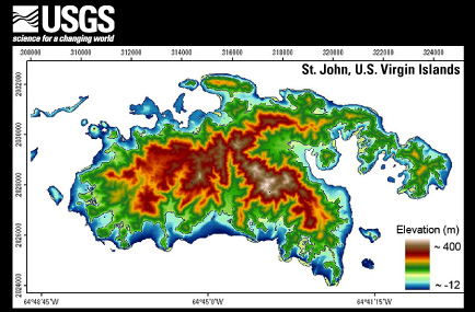
St. John, U.S. Virgin Islands

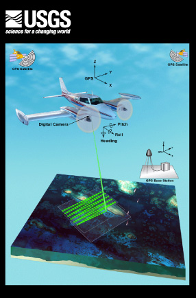
Graphic Depicting Lidar Process

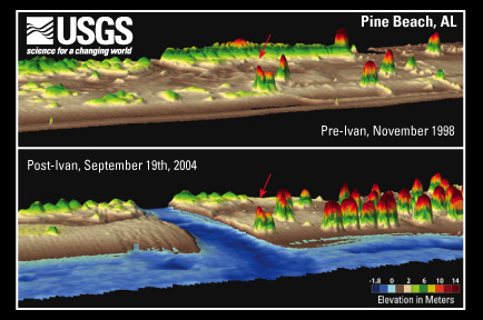
Pine Beach, Alabama, pre- and post-Hurricane Ivan

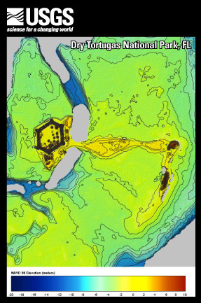
Dry Tortugas National Park, Florida


Accessibility FOIA Privacy Policies and Notices

Take Pride in America logo USA.gov logo U.S. Department of the Interior | U.S. Geological Survey
URL: http://pubsdata.usgs.gov/pubs/gip/124/index.html
Page Contact Information: USGS Publications Team
Page Last Modified: Wednesday, 30-Nov-2016 12:21:22 EST