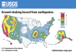
U.S. Geological Survey Earthquake Hazard Map for the United States showing earthquake
ground accelerations (horizontal) having a 10 percent probability of
being exceeded in 50 years for a firm rock site condition. This map is
based on seismicity and fault-slip rates and takes into account the frequency
of occurrence of earthquakes of various magnitudes. Locally, hazard may
be greater than that shown, because site geology may amplify ground motions.
Maps for other parameters and probabilities of exceedance may be found
on the Internet at http://eqhazmaps.usgs.gov/.
Version 1.0
|
| Posted July 2005 |
|
Part or all of this publication is presented in Portable Document Format. The
latest version of Adobe Acrobat Reader or similar software is required
to view it. If you wish to download the latest version of Acrobat
Reader free of charge, click here.
|
High-quality printed paper copies of this postcard are available for purchase
at Information Services, U.S. Geological Survey (1-888-ASK-USGS).
|
