Georiga Water Science Center
U.S. Geological Survey General Interest Publication 4
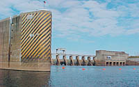 Jim Woodruff Lock and Dam. Photo by Lynn J. Torak, USGS
The Jim Woodruff Lock and Dam impounds the Flint and Chattahoochee Rivers at their confluence, creating Lake Seminole. The USGS is conducting a study on Lake Seminole, in cooperation with the Georgia Environmental Protection Division (GaEPD), to:
• develop a water budget for the lake;
• compare 2001 and pre-Lake Seminole ground-water and surface-water flows;
• evaluate possibility of a substantial amount of water entering the ground-water system from the lake, flowing beneath Jim Woodruff Lock and Dam, and entering Florida; and
• assess the likelihood of increased dissolution in the karst limestone of the lake bottom leading to sinkhole collapse and sudden lake drainage.
Recent USGS publications on Georgia or Georgia Water-Resources Information
For more information, please contact webmaster-ga@usgs.gov.

![]() U.S. Department of the Interior | U.S. Geological Survey
U.S. Department of the Interior | U.S. Geological Survey
URL: https://pubsdata.usgs.gov/pubs/gip/2006/04/htdocs/map-sw.html
Page Contact Information: Publications Team
Page Last Modified: Wednesday, 30-Nov-2016 12:11:37 EST