Western Coastal and Marine Geology
[Postcard]
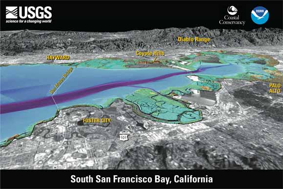
The U.S. Geological Survey, in cooperation with the California Coastal Conservancy and the National Oceanic and Atmospheric Administration, mapped the floor of south San Francisco Bay and adjoining land using single-beam sonar and airborne lidar (light detection and ranging). To learn more, visit https://pubs.usgs.gov/sim/2007/2987/.
View eastward. Elevations in mapped area color coded: purple (approx 15 m below sea level) to red-orange (approx 90 m above sea level). South San Francisco Bay is very shallow, with a mean water depth of 2.7 m (8.9 ft). Trapezoidal depression near San Mateo Bridge is where sediment has been extracted for use in cement production and as bay fill. Land from USGS digital orthophotographs (DOQs) overlaid on USGS digital elevation models (DEMs). Distance across bottom of image approx 11 km (7 mi); vertical exaggeration 1.5X.
Download the postcard (gip57.pdf; 2.1 MB)
For questions about the content of this report, contact Helen Gibbons
Suggested citation and version history
Download a free copy of the latest version of Adobe Reader.
| Help
| PDF help
| Publications main page | Western General Information Products |
| Geology |
Western Coastal and Marine Geology Program
|
This report is also available in print from:
USGS Information Services, Box 25286,
Federal Center, Denver, CO 80225
telephone: 888 ASK-USGS; e-mail: infoservices@usgs.gov

![]() U.S. Department of the Interior | U.S. Geological Survey
U.S. Department of the Interior | U.S. Geological Survey
URL: https://pubs.usgs.gov/gip/57/
Page Contact Information: Michael Diggles
Page Created: June 17, 2009
Page Last Modified: June 17, 2009
(mfd)