Western Coastal and Marine Geology
[Postcard]
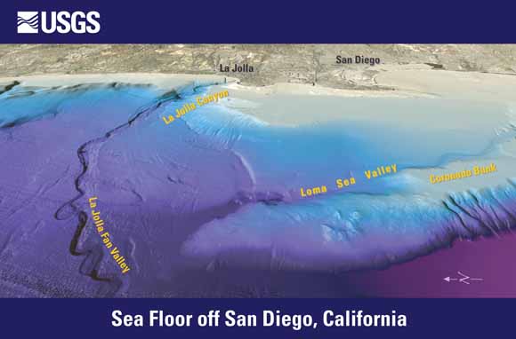
Ocean-floor image generated from multibeam-bathymetry data acquired by the U.S. Geological Survey (USGS); Woods Hole Oceanographic Institution; Scripps Institution of Oceanography; California State University, Monterey Bay; and Fugro Pelagos. To learn more, visit https://pubs.usgs.gov/sim/2007/2959/.
View eastward. Elevations color coded, from purple (deep) to pale blue (shallow). Lower right: ridge capped by Coronado Bank is separated from the continental shelf by Loma Sea Valley. Left of center: La Jolla submarine canyon and fan with meandering channel. Land from satellite imagery draped over USGS digital elevation models (DEMs). Distance across bottom of image is about 30 km (20 mi); vertical exaggeration is 2X.
Download the postcard (gip87.pdf; 651 kB)
For questions about the content of this report, contact Helen Gibbons
Suggested citation and version history
Download a free copy of the latest version of Adobe Reader.
| Help
| PDF help
| Publications main page | Western General Information Products |
| Geology |
Western Coastal and Marine GeologyProgram
|
This report is also available in print from:
USGS Information Services, Box 25286,
Federal Center, Denver, CO 80225
telephone: 888 ASK-USGS; e-mail: infoservices@usgs.gov

![]() U.S. Department of the Interior | U.S. Geological Survey
U.S. Department of the Interior | U.S. Geological Survey
URL: https://pubs.usgs.gov/gip/87/
Page Contact Information: Michael Diggles
Page Created: June 3, 2009
Page Last Modified: June 3, 2009
(mfd)