


|
|
The northern Mojave Desert. The Landsat Thematic Mapper (TM) acquires data in seven bands of the electromagnetic spectrum. On this image, white and yellow colors indicate rocks rich in clay minerals and limonite in rocks of red and yellow hues. The large concentrations of limonite and clays may indicate mineral deposits exposed at the surface or buried up to several thousand feet below it (photograph courtesy of Mel Podwysocki). |
The first Shuttle Imaging Radar System (SIR-A), flown on the U.S. space shuttle Columbia in 1981, recorded images that show buried fluvial topography, faults, and intrusive bodies otherwise concealed beneath sand sheets and dunes of the Western Desert in Egypt and the Sudan. Most of these features are not visible from the ground. The radar signal penetrated loose dry sands and returned images of buried river channels not visible at the surface. These images helped find new archeologic sites and sources of potable water in the desert. These "radar rivers" are the remnants of a now vanished major river system that flowed across Africa some 20 million years before the development of the Nile River system. Radar imagery also is a powerful tool for exploring for placer mineral deposits in arid lands.
In 1972, the United States launched the first of a group of unmanned satellites collectively known as Landsat. Landsat satellites carry sensors that record "light," or portions of the electromagnetic spectrum, as it reflects off the Earth. Landsat acquires digital data that are converted into an image.
The scarcity of vegetation makes spectral remote sensing especially effective in arid lands. Rocks containing limonite, a hydrous iron oxide, may be identified readily from Landsat Multispectral Scanner data. The Landsat Thematic Mapper (TM) has increased our ability to detect and map the distribution of minerals in volcanic rocks and related mineral deposits in arid and semiarid lands.
More than a million images of Earth have been acquired by the Landsat satellites. A
Landsat image may be viewed as a single band in black-and-white, or as a
combination represented by three colors, called a color composite. The most
widely used Landsat color image is called a falsecolor composite because it
reproduces the infrared band (invisible to the naked eye) as red, the red band as
green, and the green band as blue. Healthy vegetation in a false-color composite
is red.

|
|
The Landsat simulated true color mosaic (left) shows the Selima Sand Sheet covering all but rocky areas of the Sahara Desert in Sudan. On the right, a 50-kilometer-wide strip of Shuttle Imaging Radar, SIR-A, is placed over the Landsat mosaic to reveal old stream channels and geologic structures like these. Structures that are otherwise invisible under the surface sands are potential sources of water, placer minerals, ancient artifacts, and information on changes of climate in arid areas (courtesy of USGS Image Processing Facility, Flagstaff). |
Desert studies still are hampered in many regions by lack of accurate climate data. Most desert weather stations are in oases surrounded by trees and buildings and have been subjected to many location and elevation changes throughout the life of the station. Data from oases do not reflect conditions from the surrounding desert. A wide variety of instruments has been used to record measurements over varying lengths of time and in different formats, making data difficult to interpret and compare.
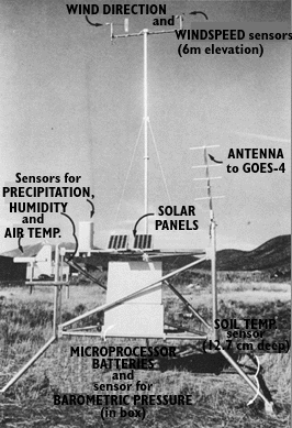
To overcome some of these problems in deserts of the American Southwest, the U.S. Geological Survey (USGS) established its Desert Winds Project to measure in a standard format several key meteorologic characteristics of arid lands. Project scientists have successfully established instrument stations to measure windspeed, including peak gusts, which alter the landforms the most. A station recorded a windstorm near Vicksburg, Arizona, for example, with peak gusts of almost 150 kilometers per hour. Using low-maintenance, automatic, solar-powered sensors, the stations also measure wind direction, precipitation, humidity, soil and air temperatures, and barometric pressure at specific heights above the surface. Data are sampled at 6-minute intervals and transmitted every 30 minutes to a Geostationary Operational Environmental Satellite (GOES). From GOES, the data are transmitted to the USGS laboratory in Flagstaff, Arizona.
The Desert Winds Project's investigators
combine analyses of data with detailed geologic field studies and repetitive
remote-sensing coverage in order to investigate and understand the long-term
changes produced by wind in deserts of differing geologic and climatic types.
|
|
TThis geometeorologic station of the Desert Winds Project easures wind speed amd direction, soil and air temperature, and precipitation and humidity in the Great Basin Desert (photograph by Carol Breed). |


