
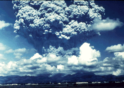
An 18 km-high volcanic plume from one of a series of explosive eruptions of Mount Pinatubo beginning on 12 June 1991, viewed from Clark Air Base (about 20 km east of the volcano). Three days later, the most powerful eruption produced a plume that rose nearly 40 km, penetrating well into the stratosphere. (Photograph by David H. Harlow, USGS.)
![]() U.S. Department of the Interior |
U.S. Geological Survey
U.S. Department of the Interior |
U.S. Geological Survey
URL: https://pubsdata.usgs.gov/pubs/gip/dynamic/Pinatubo.html
Page Contact Information: Molly Newbrough or Pubs Warehouse
Page Last Modified: Friday, July 11, 2025, 12:56:36 PM