
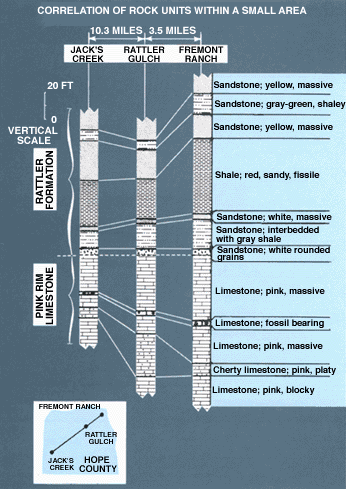
These sections are typical of the ones geologists prepare when studying the relationships of layers of rocks (beds) throughout a region. Each column represents the sequence of beds at a specific locality. The same beds, which in places may thicken or thin (some may pinch out entirely) according to the local environment of deposition, are bracketed within the lines connecting the three columns.For convenience, geologists commonly group adjoining beds that possess similar or related features (including fossils) into a single, more conspicuous unit called a formation. The component beds of each formation are described, the formation is named, and the information is published for the use of all geologists. Formation names comprise two or more words, the first part usually taken from a geographic feature near which the rocks are prominently displayed. The last word indicates the principal rock type, or if of mixed rock types, the word formation is used: The Morrison Formation--the Wingate Sandstone--the Todilto Limestone--the Mancos Shale.