
 � �
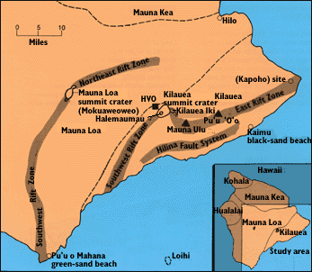
Sketch map of the southeastern part of the island of Hawaii and adjacent offshore, showing the principal features and localities of Mauna Loa, Kilauea, and Loihi Volcanoes discussed in the text. |
Hawaii's worldwide image as an idyllic tropical paradise is well deserved. What
is less well-known, however, is that the islands exist only because of nearly
continuous volcanic activity. All of the prominent features of the Hawaiian
Islands, such as Diamond Head on Oahu, Haleakala Crater on Maui, and the huge
masses of Mauna Loa and Mauna Kea on the Big Island, are volcanic.
Since the beginning of a historical record early in the 19th century, eruptions have occurred frequently at Mauna Loa and Kilauea; these two volcanoes on the Big Island are among the most active in the world. Nearby Loihi Seamount, off the Big Island's south coast, is the newest Hawaiian volcano, not yet visible above the ocean surface. Most eruptions of Mauna Loa and Kilauea are nonexplosive, and both volcanoes are readily accessible; scientists can study them at close range in relative safety. As a result, these are two of the most intensely observed and best understood volcanoes on our planet. Research on these active volcanoes provides a basis for understanding the life story of older, now inactive Hawaiian volcanoes and similar volcanoes worldwide. Hawaii serves as a superb natural laboratory for the study of volcanic eruptions. |
|
| Liliuokalani Park, in the city of Hilo on the Big Island, typifies the tropical beauty and serenity of the Hawaiian Islands. (Photograph by John Penisten, Hilo, Hawaii.) | 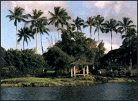 � �
|
Back | Home | Forward
<https://pubs.usgs.gov/gip/hawaii/page06.html>
Maintained by John Watson
Updated 05.01.97