
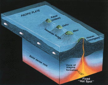
Artist's conception of the northwestward movement of the Pacific Plate over the fixed Hawaiian "Hot Spot" to illustrate the formation of the Hawaiian Ridge-Emperor Seamount Chain. (Modified from a drawing provided by Maurice Krafft, Centre de Volcanologie, Cernay, France.) |
The progressive northwesterly drift of the islands from their point of origin
over the hot spot is well shown by the ages of the principal lava flows on the
various Hawaiian Islands from northwest (oldest) to southeast (youngest), given
in millions of years: Kauai, 5.6 to 3.8; Oahu, 3.4 to 2.2; Molokai, 1.8 to 1.3;
Maui, 1.3 to 0.8; and Hawaii, less than 0.7 and still growing.
Even on the Big Island alone, the relative ages of its five volcanoes are compatible with the hot-spot theory. Kohala, at the northwestern corner of the island, is the oldest, having ceased eruptive activity about 60,000 years ago. The second oldest is Mauna Kea, which last erupted about 3,000 years ago; next is Hualalai, which has had only one historic eruption (1800-1801), and, lastly, both Mauna Loa and Kilauea have been vigorously and repeatedly active in historic times. Because it is growing on the southeastern flank of Mauna Loa, Kilauea is believed to be younger than its huge neighbor. The size of the Hawaiian hot spot is not known precisely, but it presumably is large enough to encompass the currently active volcanoes of Mauna Loa, Kilauea, Loihi and, possibly, also Hualalai and Haleakala. Some scientists have estimated the Hawaiian hot spot to be about 200 miles across, with much narrower vertical passageways that feed magma to the individual volcanoes. |
|
Back | Home | Forward
<https://pubs.usgs.gov/gip/hawaii/page12.html>
Maintained by John Watson
Updated 05.01.97