
|
| Schematic diagrams show three commonly observed stages in the course of a typical Hawaiian eruption. See text for additional discussion. (Modified from illustration by John D. Unger in Earthquake Information Bulletin, 1974, v. 6, p. 7.) |
Most of the commonly used monitoring methods were largely pioneered and developed by the Hawaiian Volcano Observatory (HVO), established in 1912 by Thomas Jaggar, Massachusetts Institute of Technology, and operated continuously by the U.S. Geological Survey since 1948. The many years of continuous observations of Kilauea and Mauna Loa, two of the world's most active volcanoes, have fostered fundamental developments in instrumentation and measurement techniques, which are increasingly used in the study of other active volcanoes the world over. Moreover, early major advances in seismic research at HVO contributed significantly to subsequent systematic investigations of earthquake and related crustal processes, now conducted as part of the Geological Survey's Earthquake Hazards Reduction Program.
The volcanic plumbing and reservoir system beneath Kilauea can be pictured schematically as a balloon buried under thin layers of sand and plaster. When magma is fed into the reservoir (analogous to air filling a balloon), the internal pressure increases, and the sand-plaster surface layers are pushed upward and outward in order to accommodate the swelling or inflation. The net effects of such inflation include the steepening of slope of the volcano's surface; increases in horizontal and vertical distances between points on the surface; and, in places, the fracturing of rock layers stretched beyond the breaking point. Such rupturing of materials adjusting to magma-movement pressures results in earthquakes. A shrinking or rapidly draining reservoir to feed surface eruptions (analogous to deflating or popping the balloon) would produce the opposite effects: flattening of slopes, reduction in distances between surface points, and decrease in earthquake frequency.
Changes in slope in a real volcano can be measured precisely by various electronic mechanical "tiltmeters" or field tilt surveying techniques, which, for example, can detect the change in slope of a kilometer-long board if raised by the thickness of a dime placed under one end. Similarly, minute changes in horizontal distances can be measured by an instrument that uses a laser beam; tiny changes in vertical distances can be measured by making a series of precise levelling surveys. Such changes can be easily detected to a precision of only a few parts per million. The notion of one part per million can be dramatized in terms of a very dry martini--1 drop of vermouth per 16 gallons of gin. The frequency, location, and magnitude of earthquakes generated by magma movement can be easily and accurately determined by data obtained from a properly designed seismic network. The Hawaiian Volcano Observatory has recently expanded its seismic networks to 45 stations to record the earthquake activity of Kilauea and Mauna Loa on a round-the-clock basis.
|
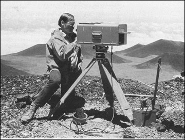
| HVO scientist makes horizontal distance measurement with a "geodimeter," an electronic-laser beam instrument. |
|
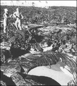
| Protected against radiant heat by foil-lined clothing and headgear, HVO scientists collect a sample of molten lava through the broken roof of a lava tube (a "skylight") using a steel cable with a weight at its end. |