The continuing intermittent eruptive activity at Mount St. Helens poses volcanic and hydrologic hazards for the foreseeable future, especially if eruption frequency and vigor increase. Specific hazards--ash fall, pyroclastic flows, mudflows, and floods-were described by scientists years before they became stark realities on May 18, 1980. Since then, as the volcano settled into a pattern of episodic, moderate and generally nonexplosive activity, the severity and regional impact of ash fall, lateral blasts, and pyreclastic flows have diminished. Given Mount St. Helens' alternations between explosive and nonexplosive activity in its past, however, the possibility of violent eruptions and attendant hazards in the future should not be discounted.
Considerable hazards still exist in the immediate vicinity of the volcano's present summit--the amphitheater-like crater, with its episodically active and growing composite lava dome. Whenever the composite dome enlarges, chances increase for collapses of its steep, irregular sides. Such collapses, in turn, could hurl rock fragments onto the crater floor and possibly trigger small pyroclastic flows through the crater breach and down the north flank of the mountain toward Spirit Lake. Rockfalls from the unstable steep walls of the crater have been common since the formation of the huge crater, posing a local but significant hazard to scientists working within it. Scientists and other people working close to or within the volcano's crater--within the "restricted zone" established by the USFS-must remember these hazards and take safety precautions.
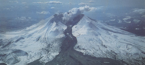
As an example of continuing hazards, mudflows triggered by the eruption of March 1982 poured down the north flank of Mount St. Helens and reached the valley of the North Fork Toutle River (Photograph by Thomas Casadevall).
Lava flows from Mount St. Helens pose little direct hazard to people or property because such flows are likely to be sluggish and, therefore, should not move fast or far from the vent. Anyone in good health should be able to outwalk or outrun the flows, and no major civil works are near enough to the volcano to be overrun by lava flows. However, such flows can melt snow and ice and thus could cause minor debris flows, mudflows, and floods.
Given the current, relatively quiet, eruptive behavior of Mount St. Helens, debris flows and floods at present constitute the greatest hazards related to volcanic activity. The potential for mudflows and floods was increased by the existence of new ponds and lakes formed when the debris avalanche of May 1980 blocked parts of the preexisting drainage to serve as natural dams. As these natural dams are composed of loose, easily erodible volcanic debris, they are structurally weak and could fail, which would trigger mudflows and floods.
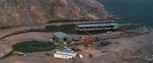
Scene at the shore of Spirit Lake showing the Army Corps of Engineers' project to control the rise of the lake level. A pump barge is at the upper left (Photograph by Lyn Topinka).
Devastating mudflows or floods or both could be triggered by any or all of the following: heavy rainfall during storms, melting of snow and ice by hot eruptive products (especially pyroclastic flows), or sudden failure of one of the lakes impounded by the debris avalanche deposits. During winter--the time of peak precipitation and maximum snowpack-the risks of mudflows and floods increase significiantly. Normal precipitation in the Mt. St. Helens area is heavy, especially on the volcano's upper slopes, where the average annual rainfall totals 140 inches. In a normal winter, the snowpack on the volcano's higher slopes can be about 16 feet thick. Thus, scientists and civil authorities were rightly concerned about the high potential for mudflows and floods, and the Army Corps of Engineers began to take engineering measures-including sediment-retention structures and channel dredging--in the drainages most vulnerable to mudflow and flood hazards.
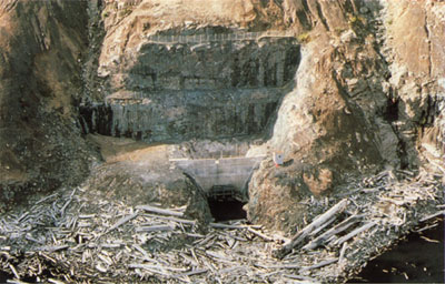
The inlet of the diversionary tunnel at Spirit Lake, part of the permanent system now used to regulate lake level. The tunnel is 11 feet in diameter and 1.5 miles long. Large logs and other debris deposited by the lateral blast on May 18, 1980, float on the lake surface around the inlet (foreground). (Photograph by Lyn Topinka in October 1986).
As an example of the flood hazards in the Mount St. Helens region, in August 1980 the failure of a natural debris dam caused the rapid draining of a 250-acre-feet lake in the Toutle River Valley near Elk Rock. (One "acre-foot" of water is equal to the volume contained in a one-foot layer covering one acre , or about 325 thousand gallons.) The ensuing flood damaged a partially constructed sedimentretention structure and heavy channel-maintenance equipment in the North Fork of the Toutle River. Fortunately, no injuries or deaths resulted. During the next 9 months, no large floods happened, largely because no high-intensity rainfalls occurred even though the total precipitation for the winter and spring of 1980-1981 was near normal. There were no major mudflows or floods the following winter-spring, again because rainfall generally was low intensity. Meanwhile, the levels of the lakes impounded by natural dams, however, gradually rose due to rainfall and runoff.
By the fall of 1982, the debris dams for three of the largest lakes-at Spirit Lake, Coldwater Creek, and South Fork Castle Creek-were becoming substantially filled, thereby increasing the risk of catastrophic flooding should the dams fail or be overtopped. The Corps of Engineers, which in 1981 started construction of controlled outlets at Coldwater and Castle Lakes, began also to control the rise of the level of Spirit Lake by an interim plan of barge-based pumping and discharge into outlet channels. The USGS and the National Weather Service installed flood-warning systems in the Toutle and Cowlitz River Valleys. By March 1983, Spirit Lake contained 360,000 acre-feet of water, the lake at Coldwater Creek had 67,000 acre-feet, and that at South Fork Castle Creek had 1·9,000 acre-feet. Scientists and engineers estimated that a breach of the natural dam at South Fork Castle Creek, the smallest of the three lakes, could unleash mudflows and floods comparable to those triggered by the May 18, 1980, eruption of Mount St. Helens. The Corps of Engineers and other Federal, State, and county agencies initiated a variety of projects to mitigate the growing hydrologic hazards. These mitigation projects required many people and much equipment to work in the hazardous zones close to the volcano. To ensure the safety of the mitigation operations, scientists had to intensify their monitoring efforts not only of the volcano itself but also of the debris-clogged drainage systems.
Though less severe now than in the early 1980s, mudflow and flooding hazards should exist for many years, until such time as the slopes and areas around Mount St. Helens, by revegetation and normal erosion, return to or approach their pre-eruption forest cover, stream gradients, rates of flow, discharge, and channel dimensions. As part of a long-term plan to cope with the continuing hydrologic hazards, the Corps of Engineers, in April 1985, completed the construction of al.5 mile-long diversionary tunnel at Spirit Lake. This permanent tunnel system replaced the temporary, barge-based pumping operations to regulate the lake's water level.
Since May 1980, the natural recovery of the drain. age system around Mount St. Helens has been substantial. Yet, during this recovery period, some roads in the region sustained significant damage from mudflows and floods, and a number of homes were lost because of stream-bank erosion. However, much more damage would have occurred if it were not for the construction of sediment-retention structures, dredging, and other engineering mitigation measures taken by the Army Corps of Engineers. It should be emphasized, however, the recovering drainage system has not been subjected to a truly major storm during the past decade. Thus, scientists, engineers, and government officials must continue to closely assess and monitor the continuing volcanic and hydrologic hazards. Human efforts to control the floods and sedimentation are designed not only to gain time to lessen the impact of hydrologic hazards until the natural "healing" of the drainage systems around Mount St. Helens is complete, but also to try to guide, if possible, the healing process.
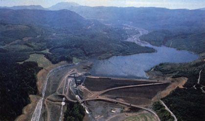
Aerial view of a sediment-retention structure, in the North Fork of the Toutle River, used to reduce mudflows and flood hazards (Photograph courtesy of the Army Corps of Engineers). Mount St. Helens can be seen on the skyline (upper left).
Scientists' Challenge and Opportunity![]()

URL: <https://pubs.usgs.gov/gip/msh/continuing.html>
Contact: John Watson
Last updated: 06.25.97