During the initial hours of the May 18 activity, people were obviously confused about the nature and sequence of the phenomena taking place. Did the eruption trigger the 5.1 magnitude earthquake or did the earthquake trigger the eruption? Or were both associated with some other, but unknown, cause or causes? At first, these questions and others could not be answered because of the rapidity of developments and the initial lack of firsthand observations by people who were close to the mountain and who survived the catastrophe. It was not until many hours, indeed days, later that scientists were able to reconstruct clearly the sequence of events. The reconstruction was aided by eyewitness accounts. Geologists Keith and Dorothy Stoffel, flying over the volcano in a small plane when the earthquake struck, observed "minor landsliding of rock and ice debris" into the crater. Within the next 15 seconds, the north flank of the volcano "began to ripple and churn up, without moving laterally." At the same time the Stoffels were witnessing from the air the developing debris avalanche, a remarkable series of ground-based photographs was being taken by Keith Ronnholm and Gary Rosenquist from Bear Meadows, a camping area located about 11 miles northeast of Mount St. Helens. Seconds after the earthquake, William Dilly, a member of the Rosenquist party, noticed through binoculars that the north flank was becoming "fuzzy, like there was dust being thrown down the side" and shouted that the "mountain was going." Within seconds Rosenquist began taking photographs in rapid succession.
Frame-by-frame analysis of the Rosenquist photographs, taken within a span of about 40 seconds, together with seismic and other evidence, established the following sequence of events during the first minute of the climactic eruptions. The times indicated are in hours, minutes, and seconds (Pacific Daylight Time).
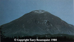
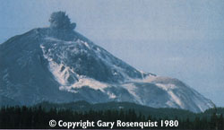
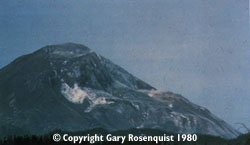
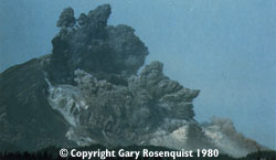
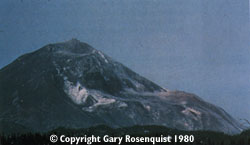
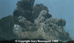
These photographs were selected from the sequence taken by Gary Rosenquist (©copyright Gary Rosenquist 1980).
08:27 (approximate) Pre-earthquake view of the bulge on the volcano's north flank produced by the growing cryptodome of magma intruded since March 20. About 5 minutes later (08:32:11.4 PDT), a 5.1 magnitude earthquake struck beneath the mountain at shallow depth. |
08:32:53.3 The first slide block now had dropped sufficiently to expose more of the cryptodome magma, accelerating the explosive expansion of gases in the magma and the eruption of the first magmatic material of the 1980 eruptions. |
08:32:47.0 Estimate of the time of the first photograph in Rosenquist's sequence that shows movement of the mountain. By this time, the first slide block had already dropped about 2,300 feet and a second block behind it had slid 330 feet. The beginning of the north flank's collapse and downward movement to initiate the debris avalanche was estimated to be 26 seconds earlier (08:32:21.0 PDT). |
08:33:03.7 The continuing movement of the slide blocks and explosions had now thoroughly "uncorked" the magmatic system of the cryptodome, and old and new (magmatic) debris were blasted outward by increasingly more powerful explosions. The high-velocity lateral blast cloud, with its clearly visible trajectory trails of large blocks, was overtaking the slower moving debris avalanche. |
08:32:49.2 A little more than 2 seconds later, as the slide blocks continued to move, the initial explosions of the vertical eruption column as well as the lateral blast, although obscure, had already begun. |
08:33:18.8 Less than a minute after the start of the debris avalanche, the eruption of Mount St. Helens was in full fury, further enlarging the crater as smaller slide blocks fell into the vent and were blasted away. The leading front of the lateral blast now had completely overtaken the debris avalanche. |
The lateral blast at the vent probably lasted no more than about 30 seconds, but the northward radiating and expanding blast cloud continued for about another minute, extending to areas more than 16 miles from the volcano. Shortly after the blast shot out laterally, the vertically directed ash column rose to an altitude of about 16 miles in less than 15 minutes, and the vigorous emission of ash continued for the next 9 hours. The eruption column began to decline at about 5:30 p.m. and diminished to a very low level by early morning of May 19.
The extraordinary photographic documentation of the first minute enabled scientists to reconstruct accurately what had happened. The 5.1-magnitude earthquake caused the gravitational collapse of Mount St. Helens' north flank, which produced the debris avalanche and triggered the ensuing violent lateral and vertical eruptions. From a scientific perspective, it was fortunate that the initial May 18 events occurred during daylight hours under cloudless conditions; otherwise, the sequence of events during that crucial first minute following the earthquake would have been difficult to reconstruct precisely.

URL: <https://pubs.usgs.gov/gip/msh/catastrophic.html>
Contact: John Watson
Last updated: 06.25.97