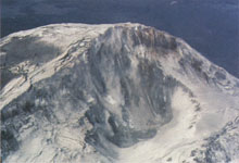
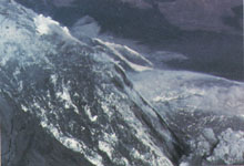
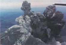
Aerial views of the volcano at the moment the summit collapse
(see text) triggered the debris avalanche and associated catastrophic eruption
(Photographs selected from the copyrighted sequence taken by Keith and Dorothy
Stoffel). The tail of the plane can be seen in the upper right-hand corner
of the lower picture, as the Stoffels took a final backward look while escaping.
Although the triggering earthquake was of slightly greater magnitude than any of the shocks recorded earlier at the volcano, it was not unusual in any other way. What happened within the next few seconds was described by geologists Keith and Dorothy Stoffel, who at the time were in a small plane over the volcano's summit. Among the events they witnessed, they
"noticed landsliding of rock and ice debris inward into the crater . . . the south-facing wall of the north side of the main crater was especially active. Within a matter of seconds, perhaps 15 seconds, the whole north side of the summit crater began to move instantaneously. . . . The nature of movement was eerie. . . . The entire mass began to ripple and churn up, without moving laterally. Then the entire north side of the summit began sliding to the north along a deep-seated slide plane. I [Keith Stoffel] was amazed and excited with the realization that we were watching this landslide of unbelievable proportions. . . . We took pictures of this slide sequence occurring, but before we could snap off more than a few pictures, a huge explosion blasted out of the detachment plane. We neither felt nor heard a thing, even though we were just east of the summit at this time."
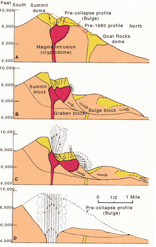 Schematic cross sections of Mount
St. Helens showing the cryptodome of magma that produced the bulge and the
three major blocks that collapsed to form the debris avalanche (After USGS
Professional Paper 1250). Compare with photographs in "The Catastrophic
First Minute."
Schematic cross sections of Mount
St. Helens showing the cryptodome of magma that produced the bulge and the
three major blocks that collapsed to form the debris avalanche (After USGS
Professional Paper 1250). Compare with photographs in "The Catastrophic
First Minute."
A, The volcano in the early morning of May 18, 1980; the bulging of the north flank is clearly shown by the pre-1980 and pre-collapse profiles.
B and C, (within about 30 seconds after the collapse) show the progressive
development of the debris avalanche and the beginning of both the lateral
blast and vertical eruption, as the cryptodome was exposed; the Bulge block
was the first to slide, followed by the Graben block.
D, (about another 30 seconds
later), by now the Summit block had slid and the lateral blast had stopped;
the vertical eruption was now in full fury.
Realizing their dangerous situation, the pilot put the plane into a steep dive to gain speed, and thus was able to outrun the rapidly mushrooming eruption cloud that threatened to engulf them. The Stoffels were fortunate to escape, and other scientists were fortunate to have their eyewitness account to help unscramble the sequence and timing of the quick succession of events that initiated the May 18 eruption.
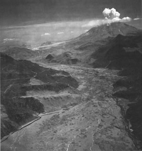 View up the North
Fork Toutle River toward Mount St. Helens (upper right) showing the valley
choked with the hummocky deposits of the debris avalanche (Photograph by
Austin Post).
View up the North
Fork Toutle River toward Mount St. Helens (upper right) showing the valley
choked with the hummocky deposits of the debris avalanche (Photograph by
Austin Post).
The collapse of the north flank produced the largest landslide-debris avalanche recorded in historic time. Detailed analysis of photographs and other data shows that an estimated 7-20 seconds (about 10 seconds seems most reasonable) elapsed between the triggering earthquake and the onset of the flank collapse. During the next 15 seconds, first one large block slid away, then another large block began to move, only to be followed by still another block. The series of slide blocks merged downslope into a gigantic debris avalanche, which moved northward at speeds of 110 to 155 miles an hour. Part of the avalanche surged into and across Spirit Lake, but most of it flowed westward into the upper reaches of the North Fork of the Toutle River. At one location, about 4 miles north of the summit, the advancing front of the avalanche still had sufficient momentum to flow over a ridge more than 1,150 feet high. The resulting hummocky avalanche deposit consisted of intermixed volcanic debris, glacial ice, and, possibly, water displaced from Spirit Lake. Covering an area of about 24 square miles, the debris avalanche advanced more than 13 miles down the North Fork of the Toutle River and filled the valley to an average depth of about 150 feet; the total volume of the deposit was about 0.7 cubic mile. The dumping of avalanche debris into Spirit Lake raised its bottom by about 295 feet and its water level by about 200 feet.
![]() The Climactic Eruption of May 18,
1980
The Climactic Eruption of May 18,
1980

URL: <https://pubs.usgs.gov/gip/msh/debris.html>
Contact: John Watson
Last updated: 03.19.02