[Click on image for a larger view] |
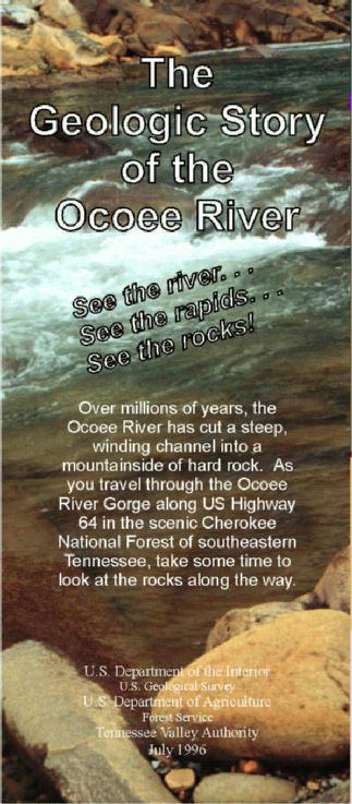
Over millions of years, the Ocoee River has cut a steep, winding channel into a mountainside of hard rock. As you travel through the Ocoee River Gorge along US Highway 64 in the scenic Cherokee National Forest of southeastern Tennessee, take some time to look at the rocks along the way.
U.S. DEPARTMENT OF THE INTERIOR
U.S. DEPARTMENT OF AGRICULTURE
|
Introduction
The Geologic Story
Maps
Folds and Faults
The Ocoee River
Mining at Ducktown
Weathering of Pyrite
More Information
This web page showcases a brochure that tells the geologic story of the rocks exposed along the Ocoee River in Polk County, east Tennessee. The brochure was prepared by the USGS, in cooperation with Forest Service and Tennessee Valley Authority (TVA), to highlight the geology along a popular stretch of the Ocoee River.
As the Nation's largest earth-science agency, the U.S. Geological Survey (USGS) collects, analyzes, interprets, and distributes information on mineral, land, and water resources to all levels of government, educators, private industry, and the public.
The USGS works closely with the Forest Service to provide geologic and resource information for land-use planning by conducting mineral-resource assessments and other studies. The Forest Service oversees much of the land in Polk County, including the Cherokee National Forest.
TVA produces maps in cooperation with the USGS. TVA operates three dams on the lower Ocoee River to produce hydroelectric power and manages the flow of water in the river.
The Ocoee River area attracts thousands of visitors every year and includes the Ocoee Whitewater Center in the Cherokee National Forest, site of the 1996 Olympic Canoe/Kayak Slalom competition.
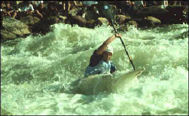
Kayaking on the Ocoee. [Photograph by Carter Hearn]
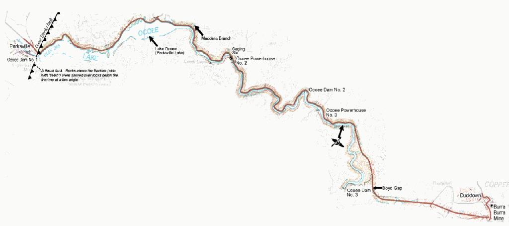
US Highway 64 follows the Ocoee River through the gorge, east of the town of Cleveland, Tennessee. Many interesting rocks can be seen from the highway in roadcuts and in the river bed starting near Ocoee Dam No. 1 (Parksville Dam). East of Ocoee Dam No. 3, the Ocoee River turns south and Highway 64 continues east to Ducktown.
As you read the geologic story, follow the map
 and photo
  icons to see some of the geologic features along the Ocoee River. The map will open in a new window.
The Geologic Story
The Earth is about 4.5 billion (4,500,000,000) years old. Over long periods of time, ancient continents have
moved great distances, oceans have formed and later disappeared, and mountains have risen and worn
away. Geologists read the history of the Earth, in part, by studying the rocks at the surface. Present-day
locations of different types of rocks, and the minerals, textures, and structures (faults and folds) within rock
units, are largely the result of
plate tectonics - the formation, movement, and collision of
plates (continent-size, rigid slabs of solid rock). Here is a glimpse of part of the geologic story revealed by rocks in the
southeastern United States:
750 to 570 million years ago (during the Late Proterozoic Era)

750 to 570 million years ago
570 to 460 million years ago

 Rocks buckled into folds and large blocks of rock slid over each other along the Great Smoky fault. Heat
and pressure increased due to these collisions and transformed sedimentary rocks into metamorphic rocks.
For example, shale became slate. These events built the present-day Appalachian Mountains.
Rocks buckled into folds and large blocks of rock slid over each other along the Great Smoky fault. Heat
and pressure increased due to these collisions and transformed sedimentary rocks into metamorphic rocks.
For example, shale became slate. These events built the present-day Appalachian Mountains.
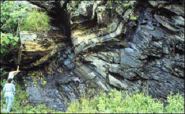
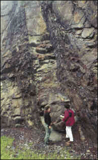
Light and dark gray bands in the rocks that we see along the Ocoee River Gorge today originally were
layers of sediments that were deformed during this era. The lighter colored layers are coarser grained and
harder than the darker colored layers. The hard, coarse grained layers form ledges that make many of the
rapids in the river.
220 to 185 million years ago
European settlers started mining and smelting metal ores in Copper Basin (Ducktown).
The first dam (Ocoee Dam No. 1 or Parksville Dam) was completed on the Ocoee River
to generate hydroelectric power. This dam created Lake Ocoee (Parksville Lake). USGS began
monitoring the flow along the Ocoee River.
Geologic processes and human activities continue to change the landscape around
you. Weathering from rain and snow erodes the hills and mountains as the rivers and
streams carve deeper channels into the Earth. Weathering includes all processes (physical and
chemical) that decompose bedrock and form soils.
Maps
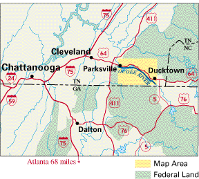
Area surrounding the Ocoee River Gorge.
Topographic map of the Ocoee River Gorge area.
This map shows part of the Cleveland, Tennessee-North Carolina, 1:100,000-scale topographic map. This map is one example of the many different kinds of maps that the USGS and TVA provide for the public.
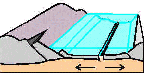
Folds and Faults
The Great Smoky fault intersects the Earth's surface near Ocoee Dam No. 1 (Parksville Dam). Faults and
folds formed when older rocks were shoved over younger rocks during a continental collision more than
240 million years ago. The fault marks the boundary between two physiographic provinces: the Valley and
Ridge province to the west and the Blue Ridge province to the east. Landforms are different on either side
of the fault because rocks on the east side are more resistant to weathering and erosion than the younger
rocks to the west. The fault is no longer active.
The Ocoee River
The great power of this river has been harnessed at three points to generate electricity. At Ocoee Dam No.
3, water from the Ocoee No. 3 Lake is diverted to Powerhouse (PH) No. 3 through a tunnel cut through the
rock on the west side of the river. The river channel between the dam and the powerhouse normally carries
only local flow and, when necessary, flood releases from the lake. A 1,500 ft (457 m) long stretch in this
segment of the river was modified to create the Ocoee Whitewater Center, the site of the 1996 Olympic
Canoe/Kayak Slalom competition. TVA can release water at Ocoee Dam No. 3 to provide flow for the
whitewater course. Unlike a natural stream, most of the flow in this segment of the river can be turned on
and off. Downstream, the water is used again as it is diverted through a flume from Ocoee No. 2 Dam to
PH No. 2.
The rate of water released for competitions at the Ocoee Whitewater Center is about 1,400 cubic feet per second (628,320 gallons per minute, or 39.6 cubic meters per second). As you consider the amount of turbulence and whitewater that this discharge provides, you might imagine the awesome power of this river when in flood - on November 19, 1906, an estimated discharge of 62,000 cubic feet per second (27,800,000 gallons per minute, or 1,756 cubic meters per second) passed the gaging station site just downstream from PH No. 2.
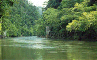 USGS stream gaging station 700 feet (213 meters) downstream from Ocoee Powerhouse No. 2. [Photograph by David Usher, U.S. Geological Survey] |
The USGS operates stream-gaging stations along the Ocoee River in cooperation with the Tennessee Valley Authority (TVA) and the Tennessee Ocoee Development Agency. Stream flow data have been collected continuously since 1913 at the gaging station site shown in the photo and on the map (station 03563000 near the former village of Emf, TN). Another recently installed submerged sensor at Slam Dunk (one of the named natural bedrock ledges that forms an eddy in the channel at the Ocoee Whitewater Center) transmits data continuously to TVA. Data from these stations enable TVA to determine discharge rates and maintain flow within a specified range along the canoe/kayak competition course.
|
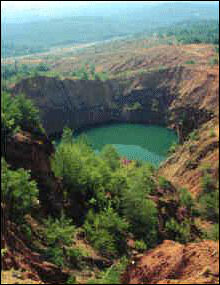
Copper was used by Native Americans in the Copper Basin area. European settlers "rediscovered" copper
at Copper Basin in the tri-state area of Tennessee, Georgia, and North Carolina in 1843 and started mining
it. Mines produced copper, iron, sulfur, zinc, and small amounts of gold and silver. Before 1900, Copper
Basin was the largest metal mining district in the Southeast. The last mine closed in 1987.
|
|
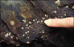
Pyrite (fool's gold) was one of the minerals mined in Copper Basin. Pyrite is iron sulfide and has the
chemical formula FeS2. You can see gold-colored cubes of pyrite scattered through many of the rocks
along the Ocoee River. Weathering of pyrite has made the rusty-colored stains on some of the outcrops.
When pyrite is exposed to air and water, it can become chemically unstable and change to other minerals, releasing acid in the process. Acidic conditions can develop in streams and be harmful to fish and plants. This acid-generating process can happen naturally, or when roadcuts are made to build highways, or when pyrite-rich rocks are piled up as waste rock tailings from metal or coal mining. Limestone was one of the types of rocks used to modify the river channel at the Ocoee Whitewater Center because limestone counteracts the acid contained in storm runoff.
|
This publication is one of a series of general interest publications prepared by the U.S. Geological Survey to provide information about the earth sciences, natural resources, and the environment. To obtain a catalog of additional titles in the series "General Interest Publications of the U.S. Geological Survey," write:
URL https://pubs.usgs.gov/gip/ocoee2/