

Partnerships for Progress at the U.S. Geological Survey |
Online Edition |
|| Earth Science in the Public Service: Research Themes || Partnerships: How and Why ||
Digital map revision using Revpg |
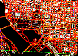
This is about opportunity for the private sector. It is about combining the research capabilities of Government scientists with the commercial development potential of private companies. It is, consequently, about partnerships leading to products and services to enhance the quality of life and strengthen the American economy. The image at the left shows a computer screen image of Washington, DC using RevPG software for map revision.
Case 1:Environmental Systems Research Institute Inc. (ESRI), one of the leading geographic information system (GIS) software vendors, markets ARC/INFO as its flagship product. The U.S. Geological Survey (USGS) has used ARC/INFO successfully in various high-tech applications for a number of years. In adapting this product to conventional map revision applications, the USGS developed revision-product generation software, or RevPG, to run in conjunction with ARC/INFO for the revision of USGS maps. ESRI was immediately interested in RevPG primarily because distribution of this new software would broaden the ESRI market from predominantly GIS users to more conventional cartographers. ESRI managers felt that RevPG, as written by the USGS, needed some changes to increase its appeal in the commercial market, so ESRI and the USGS recently executed a Cooperative Research and Development Agreement (CRADA) to make the needed changes. ESRI, because of the potential benefits to the company in increased sales of ARC/ INFO and other products, agreed to assist in system design and integration to enhance RevPG. By increasing the number of GIS users capable of producing data to USGS standards, the Government will also benefit. Both parties have agreed to distribute the new product.
Case 2:USGS scientists are working with the Pacific Gas and Electric Company (PG&E) to develop a prototype realtime earthquake notification system for the San Francisco Bay Region. The USGS Office of Earthquakes, Volcanoes, and Engineering is developing technology to monitor earthquakes as they occur and rapidly assess subsequent damage. The two institutions have executed an agreement through which PG&E will use this realtime seismic information from the USGS to alert utility system operators to the occurrence of a major earthquake and help guide the post-earthquake damage assessment and recovery plan.
These are just two recent examples of working partnerships formed between the USGS and private companies to promote the transfer of technology developed by the Government into the commercial sector. This kind of activity is not new to the USGS, but the pace of its development is accelerating.
|| Top ||
|| Information || Hazards || Resources || Environment ||
The USGS is devoted to providing earth science information for the public good. It employs professionals in geology, geophysics, geochemistry, hydrology, cartography, remote sensing, computer programming, and information science who work as research teams in these and related disciplines.
To ensure that USGS research and the products generated from it are relevant to the Nation's needs, four themes guide our programs: information, hazards, resources, and the environment. Everything we do fits into one of these areas. If your business is involved in any of these theme areas, you may be interested in a partnership with the USGS.
The USGS's primary stockand trade is information. We generate huge amounts of scientific data on surface- and subsurface-water quantity and quality, minerals availability, probabilities of natural hazards, land use and land cover, slope and elevation of land features and numerous related topics. We distribute additional data on behalf of other agencies that gather it.
All this information is released as reports published by the USGS, scientific journal and conference contributions, maps, and, increasingly, data bases in various electronic media.
We have become researchers and developers of the Information Age. This is the activity that generated the RevPG CRADA with ESRI, as well as growing expertise in the management and distribution of information dispersed on the Internet and in the arrangement of data for release on compact discs and a generous array of magnetic media.
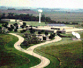
EROS Data CenterSioux Falls, South Dakota |
At Sioux Falls, South Dakota, for example, the Survey's Earth Resources Observation System Data Center staff conducts research and distributes data and images from earth-orbiting satellites. The data are increasingly important as a resource to study global change. The means of distribution represents pioneering work in providing high-tech, high-quality, high-volume information online. Increasingly, we are using the skills and resources of the Data Center's staff to put more information online, including traditional cartographic data. This work is becoming the foundation of a national spatial data infrastructure, a vast electronic library of information on the land surface, the processes acting upon it, and their impacts.
Through a network of regional and State offices, the USGS collects massive amounts of data on the quantity and quality of water, both surface and subsurface, throughout the United States. Most of this information is available through electronic means such as the National Water Data Storage and Retrieval System.
We have become leaders in the public sector in using CD-ROM technology, because it meets much of our data distribution needs. Our CD-ROM Support Center produces many new discs each year using our own specialized equipment. The Center recently developed a set of CD-ROM's that contain seismic information for the entire East Coast of the United States. The information now is in marketable form, whereas for years it sat nearly dormant as a set of expensive 9-track tapes. Similar data are being developed continuously, all in the public domain.
Increasingly, not only the data, but the means of compiling, managing, and distributing huge electronic data sets, are becoming areas of our interest and expertise.
|| Top || Back to Research Themes Menu ||
When an earthquake occurs somewhere on the globe, our scientists are likely to have the first and most accurate information about the location and magnitude of the event. The USGS National Earthquake Information Center in Golden, Colorado, operates an extensive network of sophisticated seismographs, cooperating with nations all over the world to trace the history of earthquakes and develop models to forecast future events. Among the products of this work are rapid earthquake information dissemination systems and models that can show the likelihood of significant earthquakes over a period of years in high-risk areas. One application of this technology is demonstrated in collaboration between the USGS and the Union Pacific Railroad to develop an automatically generated fax notification system for significant earthquakes in their service area. Union Pacific will use these messages to minimize the risk of derailments by stopping trains before they enter the area of greatest earth movement and by determining where tracks need to be inspected for possible earthquake damage.
Similarly, it is our scientists who are called most frequently when a volcano threatens or damages areas of human population. We have a number of the world's most accomplished volcanologists. These scientists have been involved in saving lives and property in recent volcanic eruptions including those of Mount Pinatubo and Mount Redoubt.
The Survey is working with AT&T on a partnership that will help AT&T assess natural and technological risks to its facilities nationwide. In the event of an earthquake, contaminant spill, civil strife, or any numerous other emergencies, communications links become more important than ever. The Survey has helped AT&T find information on natural hazards and provided guidance on the use of that information for qualitative assessment of risk to their facilities. Plans are being formulated for the development of more detailed quantitative techniques for multi-hazard assessments. USGS scientists led a team of specialists from many agencies that studied the catastrophic 1993 floods along the Missouri and Mississippi rivers.
123K |
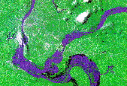
USGS scientists led a team of specialists from many agencies that studied the catastrophic 1993 floods along the Missouri and Mississippi rivers. The Landsat Thematic Mapper image at the left shows a portion of the 1993 Mississippi River Floods. The team, called the Scientific Assessment and Strategy Team, produced a substantial data base that includes information on flood-prone areas, toxic release sites, wetlands, soils, historic river channels, seasonal land cover, nesting and spawning areas, and crop statistics. The result is new information that will influence land use and planning decisions to mitigate the impacts of future floods and to make prudent choices about reuse of various sites.
93K |
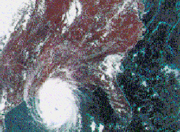
From hurricanes and floods to earthquakes and volcanoes, the hazards of nature are areas of special emphasis for the USGS. The image at the left shows Hurricane Andrew in the Gulf of Mexico in August, 1992. No single part of the USGS does all of our work on hazards. It takes the cooperative work of many experts all across the organization, the Nation, and the world to gather, interpret, and distribute the information we contribute to this vitally important area of public concern. Through technology transfer agreements, we can now add the creative drive of the private sector to this powerful system.
|| Top || Back to Research Themes Menu ||
For more than 100 years, the USGS has provided timely and credible assessments of the quality, quantity, and distribution of our Nation's mineral and energy resources, particularly on Federal lands. The results of these investigations can enhance industry's capabilities to explore and develop natural resources. Increasing emphasis at the USGS is also being placed on assessing and characterizing the environmental effects of resource development and use. Technology advances made through these efforts can often lead to partnerships with industry to develop new innovative tools and techniques to explore for mineral and energy resources and to mitigate the detrimental effects of resource development.
110K |
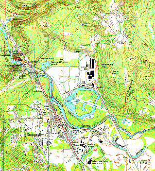
The image at the left shows a USGS 1:24,000-scale topographic map. One recent CRADA involving resource activities was executed with the Santa Fe Pacific Gold Corp. to geologically map two quadrangles in Nevada. This partnership, we believe, has let to improved understanding by both government and industry of tectonics and mineral potential of the areas studied. Another CRADA has been developed with a consortium of international oil companies to help revive the sagging petroleum industry in the newly independent States of the former Soviet Union. USGS topographic data are indispensable in the search for energy and mineral resources, as well as in the management of water resources. The shape of the land surface betrays much, to the trained eye, about the subsurface; and the direction of drainage largely determines the ways in which water can be put to human use.
GLORIA Sidescan Sonar System |
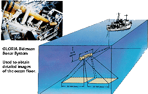
Earth science is not confined to terrestrial processes, and we are not bound to the continents. The USGS is active in marine research and technology, recently performing extensive research in the deep ocean-floor hydrothermal vents. In the 1980's, when the United States declared the area within 200 miles of our coastline as the Exclusive Economic Zone, it fell to the USGS to map the 3 million square miles of ocean floor that compose this vast and still largely unknown area of the globe. The task was accomplished by towing sophisticated side-scan sonar instruments behind ships.The image at the left shows the GLORIA Sidescan Sonar System used to obtain detailed images of the ocean floor. The resulting data are available on CD-ROM's. The USGS continues to be active in the development and the use of new sophisticated marine exploration systems and instruments.
Our mission is not to exploit, but to foster the "wise use" of our national resources. Increasingly, in recent years, this interpretation of mission has led to the fourth of our theme areas.
|| Top || Back to Research Themes Menu ||
59K |
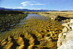
The image at the left shows the environmental pollution of The Arkansas River in Colorado . It was a USGS scientist who, a few years back, performed goundbreaking studies in the recycling of sewage sludge into fuel for electric power generation. This scientist was not the first to explore the idea, but he was the first to demonstrate that the idea was economically feasible because valuable metals, in ore-grade concentrations, could be precipitated from the sludge. Some problems still remain in the process, but possibly, so does opportunity.
A CRADA is being formulated that will put USGS scientists to work with private-sector partners on coal-cleaning procedures, trying to assess the levels of hazardous trace elements before burning coal as fuel. The work involves improvements and additions to the USGS's coal-quality data base that contains information on these elements.
In Denver, the USGS Center for Environmental Geochemistry and Geophysics (CEGG) is coordinating numerous projects that use data produced by various agencies — and private firms — for evaluating the Earth's natural resource potential. Consideration of environmental impacts is important in this work, and at times it leads to environmental remediation efforts. At a site in Summitville, Colorado, for example, the CEGG is helping to coordinate efforts with the Bureau of Mines to begin environmental cleanup. Also, CEGG is cooperating with the Bureau of Land Management, the National Forest Service and the Environmental Protection Agency to develop information on the geochemical and physical characteristics of contaminated sites.
In 1994 the USGS National Water Quality Laboratory analyzed 65,000 water samples from across the United States, producing more than 900,000 analytical results to describe the status and trends of the Nation's water supplies. Samples are gathered by scientists not only in the Survey, but in dozens of agencies at all levels of government, and sent to the laboratory for analysis.
Efforts to reduce hazards and their impacts on our environment and to use scientific data in the management and exploitation of natural resources are a growth industry in the American economy, and a specialty here at the USGS. Partnerships are natural to all of these areas.
|| Top || Back to Research Themes Menu ||
Several mechanisms for partnering with the USGS are available to private companies. These include our Industrial Research Associate Program, a patent licensing program, and various forms of cooperative agreements. To date, however, most of our technology transfer agreements have taken the form of CRADA's -- giving us confidence and offering a visible record of performance with this relatively new mechanism.
Officially, a CRADA is "any agreement between one or more federal laboratories and one or more non-federal parties under which the Government... provides personnel, services, facilities, equipment, intellectual property ... but not funds ... and the non-federal parties provide funds ... or other resources toward ... efforts which are consistent with the missions of the laboratory..." This simply means that the Government can contribute its people's time, ideas, expertise, facilities, and equipment. Private concerns can contribute those same resources as well as funding.
Any information developed by a private concern prior to commencement of an agreement remains proprietary. Information generated during work under the agreement can be protected for periods of up to 5 years.
Advantages of this device to the private sector are immediately visible. Intellectual property rights are negotiable at the outset, before such property has been created. Companies can negotiate for exclusive rights to intellectual property developed solely by the Government and share jointly in the rights to intellectual property developed jointly. CRADA's allow the private sector to share in the Federal technology development process at early stages and to influence the direction of the process to create products useful to industry. CRADA's can vastly improve the speed of technology transfer and help this Nation compete — and win — in the global marketplace.
We at the USGS will announce and advertise opportunities for CRADA's as they develop. This is a public institution, and the process is public.
A private concern interested in a cooperative venture is encouraged to make a proposal to us. If a partnership opportunity is apparent we will be eager to discuss it with you. We do our best to negotiate CRADA's and other agreements that are beneficial to both parties.
For more detailed information on this process, please contact:
U.S. Geological Survey
Technology Transfer Office
104 National Center
12201 Sunrise Valley Drive
Reston, VA 20192
703-648-4450, fax 703-648-5470
For the USGS Internet page on Technology Transfer:
www.usgs.gov/bio/USGS
/tech-transfer/index .html
[an error occurred while processing this directive]
This booklet was originally published in paper form in September, 1995. The online edition contains all text from the original publication. Some figures, however, have been modified or left out to enhance legibility at screen resolutions. This document has undergone official review and approval for publications established by the National Mapping Division, U.S. Geological Survey. [Control Number:NMD 97-298]
[an error occurred while processing this directive]