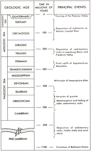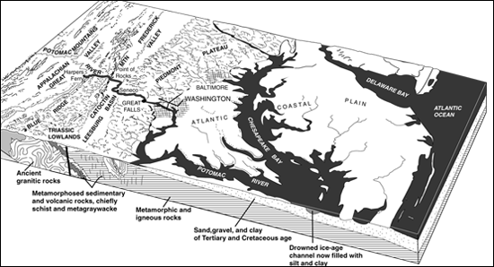
Physiographic Provinces and Geologic and Geographic Features of the District of Columbia region. |
|
Physiographic Provinces and Geologic and Geographic Features of the District of Columbia region. |
The Atlantic Coastal Plain province borders the Atlantic Ocean and consists of gravel, sand, silt, clay, and marl. Deposition of these sediments began 100 million years ago and continues to the present time. The oldest rocks in the Coastal Plain are poorly consolidated (that is, easily crumbled) gravel, sand, silt, and clay derived from the weathering of rocks to the north and west that were carried to the Coastal Plain by southflowing rivers. Younger rocks consist of sands and clays containing the minerals glauconite and mica, which were deposited in estuaries and on the Continental Shelf at a time when water covered the present Coastal Plain to depths of as much as 200 feet.
|
The Piedmont Plateau province lies west of the Coastal Plain. The Piedmont rocks in and near Washington, D.C., are crystalline metamorphic rocks that are quite hard and resist weathering; they contain veins of quartz and pegmatite and in many places have been intruded by igneous rock (formed from molten rock from inside the Earth). These crystalline rocks can be seen most easily in valleys where the soil cover has been stripped away by erosion. Most of the crystalline rocks on the uplands were deposited about 550-600 million years ago; over the ages, they have weathered to saprolite, a porous, spongy, red-brown clay-rich material, as much as 200 feet thick. The final product of weathering, seen near the surface throughout much of the Piedmont, is a sticky clay, generally having a reddish color.
The rocks of the Triassic Lowland province, deposited about 200 million years ago, are red shales and red and gray sandstones and conglomerates, which weather to a reddish soil. Near Washington these sedimentary rocks are as much as 5,000 feet thick. In some places, they have been intruded by trap rock (resistant fine-grained igneous rock). At the western edge of the Triassic Lowland is a series of alluvial fans that mark the mouths of ancient rivers. These deposits are made up of rounded to angular masses of limestone, quartz, and quartzite, which range in size from sand grains to boulders as much as 1 foot in diameter, that are cemented by calcite. The Blue Ridge province, lying west of the Triassic Lowland, is a region of north- and northeast-trending valleys and ridges underlain by folded metamorphic and igneous rocks that were formed more than 500 million years ago. Near Washington, the rocks consist predominantly of granite, greenstone (metamorphosed by great heat and pressure from basaltic lava flows), and quartzite. Sharp north-trending ridges, formed by steeply dipping quartzite that resists weathering, rise more than 1,000 feet above sea level. |
This page is https://pubs.usgs.gov/stones/setting.html
Maintained by Publications Services
Last revised 1-13-99 (krw)