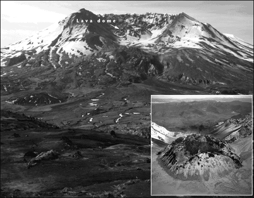
Mount St. Helens crater and lava dome viewed from the north, 1990. Inset: Close view of lava dome with new lava extrusion on top (snow-free part) from the south, 1986. (Photographs by Lyn Topinka.)
Mount St. Helens, Washington. The catastrophic eruption on May 18, 1980, was preceded by 2 months of intense activity that included more than 10,000 earthquakes, hundreds of small phreatic (steam-blast) explosions, and the outward growth of the volcano's entire north flank by more than 80 meters. A magnitude 5.1 earthquake struck beneath the volcano at 08:32 on May 18, setting in motion the devastating eruption.
Within seconds of the earthquake, the volcano's bulging north flank slid away in the largest landslide in recorded history, triggering a destructive, lethal lateral blast of hot gas, steam, and rock debris that swept across the landscape as fast as 1,100 kilometers per hour. Temperatures within the blast reached as high as 300 degrees Celsius. Snow and ice on the volcano melted, forming torrents of water and rock debris that swept down river valleys leading from the volcano. Within minutes, a massive plume of ash thrust 19 kilometers into the sky, where the prevailing wind carried about 540 million tons of ash across 57,000 square kilometers of the Western United States.
<https://pubs.usgs.gov/gip/volcus/page20.html>
Maintained by John Watson
Updated 01.04.99
![]()
![]()
![]()