 Summary Summary
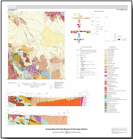
The Valley Mountain 15’ quadrangle straddles the Pinto Mountain Fault, which bounds the eastern Transverse Ranges in the south against the Mojave Desert province in the north. The Pinto Mountains, part of the eastern Transverse Ranges in the south part of the quadrangle expose a series of Paleoproterozoic gneisses and granite and the Proterozoic quartzite of Pinto Mountain. Early Triassic quartz monzonite intruded the gneisses and was ductiley deformed prior to voluminous Jurassic intrusion of diorite, granodiorite, quartz monzonite, and granite plutons. The Jurassic rocks include part of the Bullion Mountains Intrusive Suite, which crops out prominently at Valley Mountain and in the Bullion Mountains, as well as in the Pinto Mountains. Jurassic plutons in the southwest part of the quadrangle are deeply denuded from midcrustal emplacement levels in contrast to supracrustal Jurassic limestone and volcanic rocks exposed in the northeast. Dikes inferred to be part of the Jurassic Independence Dike Swarm intrude the Jurassic plutons and Proterozoic rocks. Late Cretaceous intrusion of the Cadiz Valley Batholith in the northeast caused contact metamorphism of adjacent Jurassic plutonic rocks.
The Tertiary period saw emplacement of basanitoid basalt at about 23 Ma and deposition of Miocene and (or) Pliocene ridge-capping gravels. An undated east-dipping low-angle normal fault zone in the Pinto Mountains drops hanging-wall rocks eastward and may account for part of the contrast in uplift history across the quadrangle. The eastern Transverse Ranges are commonly interpreted as severely rotated clockwise tectonically in the Neogene relative to the Mojave Desert, but similar orientations of Jurassic dike swarms suggest that any differential rotation between the two provinces is small in this quadrangle. The late Cenozoic Pinto Mountain Fault and other strike-slip faults cut Quaternary deposits in the quadrangle, with two northwest-striking faults cutting Holocene deposits.
Geographic Information System and metadata on most geologic features are available on the Geologic map of the Sheep Hole Mountains 30’ by 60’ quadrangle, U.S. Geological Survey map MF–2234, scale 1:100,000, available at
https://pubs.usgs.gov/mf/2002/2344/.
|
First posted July 29, 2013
This report is presented in Portable Document Format (PDF); the latest version of Adobe Reader or similar software is required to view it. Download the latest version of Adobe Reader, free of charge. |

