
UNCONSOLIDATED SAND AND GRAVEL AQUIFERS
INTRODUCTION
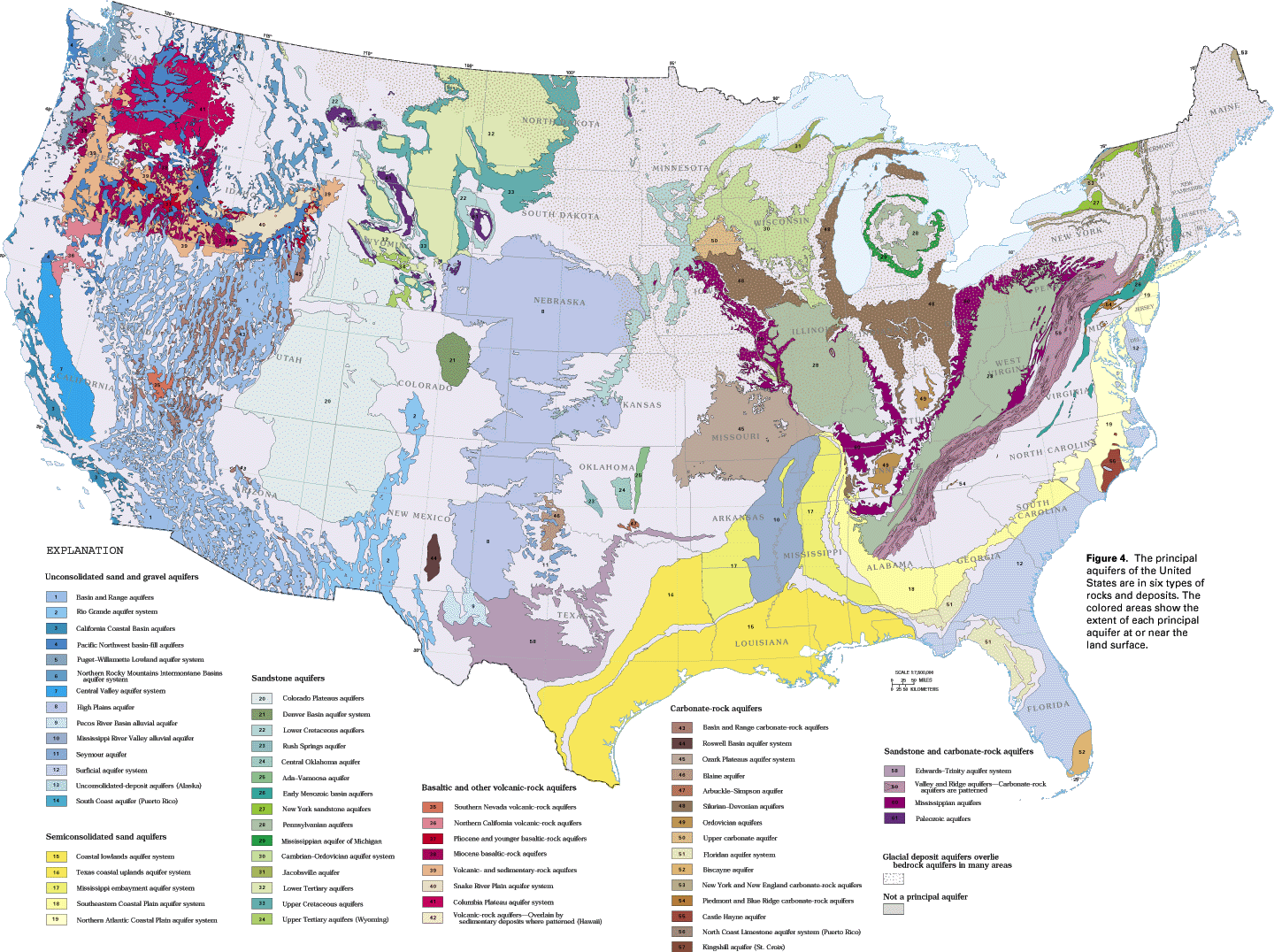
The unconsolidated sand and gravel aquifers shown in figure 4
can be grouped into the following three categories: basin-fill
aquifers, referred to as valley-fill aquifers in many reports;
blanket sand and gravel aquifers; and glacial-deposit aquifers.
A fourth type, called stream-valley aquifers, is located beneath
channels, floodplains, and terraces in the valleys of major streams.
The stream-valley aquifers are not shown on figure 4 because they
are too small to map accurately at the scale of the figure. The
most important stream-valley aquifers are mapped in the descriptive
Atlas chapters.
All the unconsolidated sand and gravel aquifers are characterized by intergranular porosity and all contain water primarily under unconfined, or water-table, conditions. However, each of the four categories occupies a different hydrogeologic setting. Examples of each category are used to illustrate these differences.
BASIN-FILL AQUIFERS
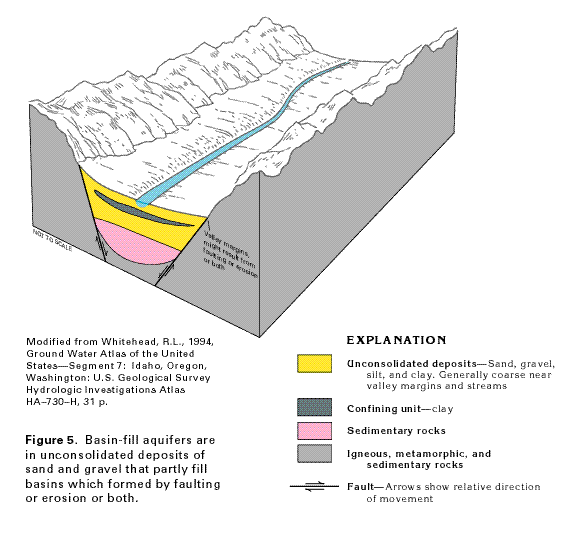
Basin-fill aquifers consist of sand and gravel deposits that partly
fill depressions which were formed by faulting or erosion or both
(fig. 5). These aquifers are also commonly
called valley-fill aquifers because the basins that they occupy
are topographic valleys. Fine-grained deposits of silt and clay,
where interbedded with the porous sand and gravel, form confining
units that retard the movement of ground water. In basins that
contain thick sequences of deposits, the sediments become increasingly
more compacted and less permeable with depth. The compacted, lithified
deposits form sedimentary rocks. The basins are generally bounded
by low-permeability igneous, metamorphic, or sedimentary rocks.
The sediments that comprise the basin-fill aquifers mostly are alluvial deposits, but locally include windblown sand, coarse-grained glacial outwash, and fluvial sediments deposited by streams that flow through the basins. The alluvial deposits consist of sediments eroded by streams from the rocks in the mountains adjacent to the basins. The streams transported the sediments into the basins and deposited them primarily as alluvial fans at the base of the mountains. The coarser sediment (boulders, gravel, and sand) was deposited near the basin margins and finer sediment (silt and clay) was deposited in the central parts of the basins. Some basins contain lakes or playas (dry lakes) at or near their centers. Windblown sand might be present as local beach or dune deposits along the shores of the lakes. Deposits from mountain, or alpine, glaciers locally form permeable beds where the deposits consist of outwash transported by glacial meltwater. Sand and gravel of fluvial origin are common in and adjacent to the channels of through-flowing streams. Basins in arid regions might contain deposits of salt, anhydrite, gypsum, or borate, produced by evaporation of mineralized water, in their central parts.
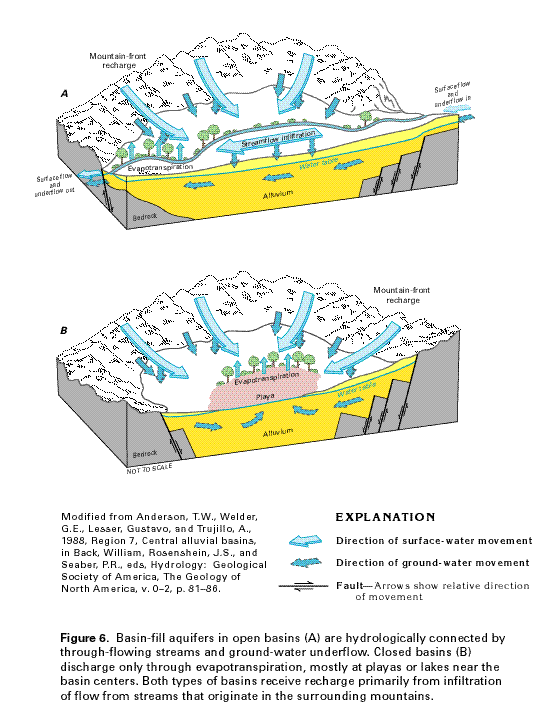
The hydrogeologic setting of a typical basin generally is one of two types: open (fig. 6A) or closed (fig. 6B). Recharge to both types of basin is primarily by infiltration of streamflow that originates as precipitation which falls on the mountainous areas that surround the basins. This recharge, called mountain-front recharge, is intermittent because the streamflow that enters the valleys is intermittent. As the streams exit their bedrock channels and flow across the surface of the alluvial fans, the streamflow infiltrates the permeable deposits on the fans and moves downward to the water table. In basins which are located in arid climates, much of the infiltrating water is lost by evaporation or as transpiration by riparian vegetation (plants on or near stream banks).
Open basins contain through-flowing streams (fig. 6A) and commonly are hydraulically connected to upstream or downstream basins or both. Some recharge might enter an open basin as surface flow and underflow (ground water that moves in the same direction as streamflow) from an adjacent upstream basin, and recharge occurs as streamflow infiltration from the through-flowing stream. Before development, water discharges from an open basin largely by evapotranspiration within the basin but also as surface flow and underflow into downstream basins. After development, most discharge is by withdrawals from wells.
No ground-water or surface-water flow leaves closed basins (fig. 6B). Streamflow and ground-water movement are from the basin boundaries toward a lake or playa usually located near the center of the basin. Predevelopment discharge in the closed basins was by evaporation and transpiration from the lake or playa area; in developed closed basins, discharge is primarily through wells.
Some basins are bounded or underlain by permeable bedrock such as carbonate rocks or fractured crystalline rocks. Where such rocks surround a basin, some ground water can enter and leave the basin through the permeable bedrock. Some carbonate rocks are highly permeable and might be cavernous where they have been partially dissolved by circulating ground water. Several basins might be hydraulically connected, especially where they are underlain by carbonate rocks, so that water moves through and between the basins as a regional or subregional ground-water flow system. In southeastern Nevada, for example, major flow systems that are described in Atlas chapter B extend for as much as 250 miles in basin-bounding carbonate rocks, and the flow mostly discharges to large springs.
Examples of basin-fill aquifers discussed in the Atlas include the Basin and Range aquifers of chapters B, C, and H; the Rio Grande aquifer system of chapters C and E; the Pacific Northwest basin-fill aquifers of chapters B and H; and the Northern Rocky Mountains Intermontane Basins aquifer system of chapters H and I. Some basin-fill aquifer systems, such as the Central Valley aquifer system described in chapter B and the Puget-Williamette Lowland aquifer system described in chapter H, are in extremely large basins.
BLANKET SAND AND GRAVEL AQUIFERS
Widespread sheetlike aquifers that consist mostly of medium to
coarse sand and gravel are collectively called blanket sand and
gravel aquifers in this report. These aquifers mostly contain
water under unconfined, or water-table, conditions but locally,
confined conditions exist where the aquifers contain beds of low-permeability
silt, clay, or marl. Where stream-valley alluvial aquifers, that
also consist of sand and gravel, cross the blanket sand and gravel
aquifers, the two types of aquifers are hydraulically connected
and the stream-valley alluvial aquifers are not mapped separately.
The blanket sand and gravel aquifers largely consist of alluvial deposits. However, some of these aquifers, such as the High Plains aquifer, include large areas of windblown sand, whereas others, such as the surficial aquifer system of the southeastern United States, contain some alluvial deposits but are largely comprised of beach and shallow marine sands.
Except for the Seymour aquifer in north Texas, which is underlain by low-permeability rocks, the blanket sand and gravel aquifers partly overlie, and are hydraulically connected to, other aquifers. Where they are in contact with aquifers in older rocks, the blanket sand and gravel aquifers store water that subsequently leaks downward under natural conditions to recharge the deeper aquifers.
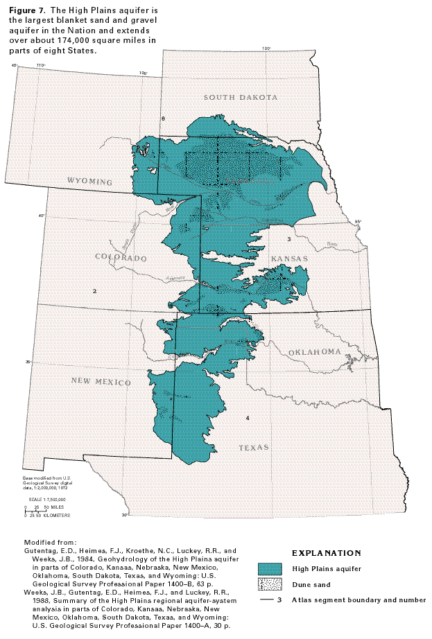
The High Plains aquifer is the most widespread blanket sand and gravel aquifer in the Nation. This aquifer extends over about 174,000 square miles in parts of eight States and four Atlas segments (fig. 7). The principal water-yielding geologic unit of the aquifer is the Ogallala Formation of Miocene age, a heterogeneous mixture of clay, silt, sand, and gravel that was deposited by a network of braided streams which flowed eastward from the ancestral Rocky Mountains. Because it consists largely of the Ogallala Formation, the High Plains aquifer has also been called the Ogallala aquifer in many reports. Dune sand is part of the High Plains aquifer in large areas of Nebraska and smaller areas in the other States (fig. 7). This permeable dune sand quickly absorbs precipitation, some of which percolates downward to the water table of the aquifer.
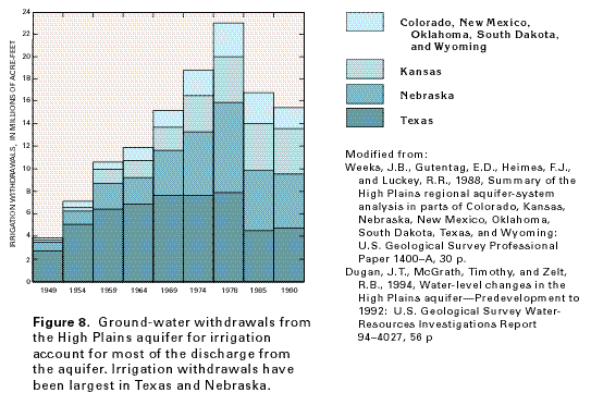
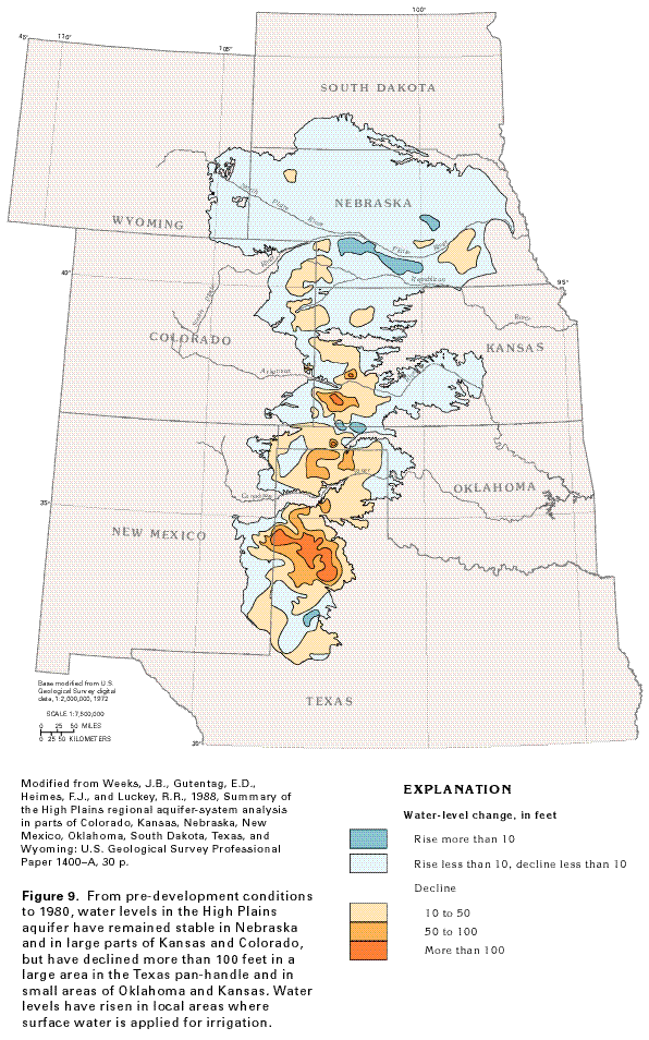
The High Plains aquifer is the most intensively pumped aquifer in the United States. During 1990, about 15 billion gallons per day, or about 17 million acre-feet per year, of water was withdrawn from the aquifer. An acre-foot is the volume of water that will cover one acre of land to a depth of one foot, or 43,560 cubic feet of water. Most of this water (almost 16 million acre-feet) was withdrawn for irrigation (fig. 8). Withdrawals during 1978 were much greater, with irrigation withdrawals amounting to almost 23 million acre-feet. Average annual withdrawals of water from the aquifer are much larger (2 to 35 times larger) than natural recharge to the aquifer. By 1980, withdrawals had resulted in water-level declines of more than 100 feet in parts of the aquifer in southwestern Kansas and the Texas panhandle (fig. 9). Declines were greatest in Texas, Kansas, and Oklahoma. Water levels rose locally in the aquifer, particularly in Nebraska, in response to increased recharge where surface water that was applied for irrigation infiltrated the aquifer.
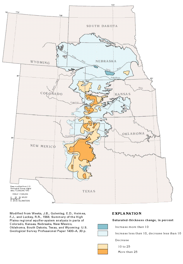
The saturated thickness of the High Plains aquifer is the vertical distance between the water table and the base of the aquifer. In 1992, the saturated thickness of the aquifer ranged from 0 where the sediments that comprise the aquifer are unsaturated to about 1,000 feet in parts of Nebraska and averaged about 190 feet. Ground-water development has caused changes in the saturated thickness of the aquifer, because this thickness changes as aquifer water levels change. Between predevelopment conditions and 1980, the saturated thickness of the aquifer decreased in many places (fig. 10), but locally increased in Texas and Nebraska. The areas of increase are the result of increased recharge to the aquifer by one or more of the following factors: greater than normal precipitation; decreased withdrawals; or downward leakage of surface-water irrigation and water from unlined canals and reservoirs. Decreases in saturated thickness of 10 percent or more result in a decrease in well yields and an increase in pumping costs because the pumps must lift the water from greater depths.
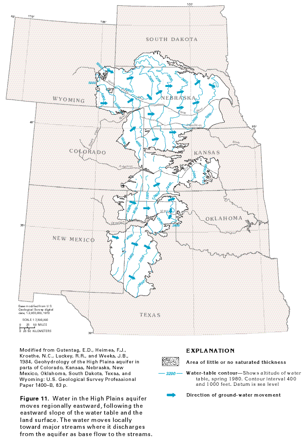
Water in the High Plains aquifer generally is unconfined. Locally, clay beds confine the water, but regionally, water-table conditions prevail. The configuration of the 1980 water-table surface of the aquifer (fig. 11) generally conforms to the configuration of the land surface. Regional movement of water in the aquifer is from west to east; locally, the water moves toward major streams. The water-table contours bend upstream where they cross the North Platte, the Republican, and the Canadian Rivers (fig. 11), indicating that water moves from the aquifer to the rivers. By contrast, the contours are either straight or bend downstream where they cross the Arkansas River, indicating that the Arkansas is a losing stream and water from the river recharges the aquifer.
Significant parts of the High Plains aquifer in Kansas, Colorado, and New Mexico are unsaturated, as shown in figure 11. In these areas, the water table is discontinuous and only local supplies of water can be obtained from filled channels that have been eroded into bedrock.
Other blanket sand and gravel aquifers include the Seymour aquifer of Texas (fig. 4) which, like the High Plains aquifer, was deposited by braided, eastward flowing streams but has been dissected into separate pods by erosion; the Mississippi River Valley alluvial aquifer, which consists of sand and gravel deposited by the Mississippi River as it meandered over an extremely wide floodplain; and the Pecos River Basin alluvial aquifer, which is mostly stream-deposited sand and gravel, but locally contains dune sands.
GLACIAL-DEPOSIT AQUIFERS
Large areas of the north-central and northeastern United States
are covered with sediments that were deposited during several
advances and retreats of continental glaciers. The massive ice
sheets planed off and incorporated soil and rock fragments during
advances and redistributed these materials as ice-contact or meltwater
deposits or both during retreats. Thick sequences of glacial materials
were deposited in former river valleys cut into bedrock, whereas
thinner sequences were deposited on the hills between the valleys.
The glacial ice and meltwater derived from the ice laid down several
types of deposits, which are collectively called glacial drift.
Till, which consists of unsorted and unstratified material that
ranges in size from boulders to clay, was deposited directly by
the ice. Outwash, which is mostly stratified sand and gravel,
and glacial-lake deposits consisting mostly of clay, silt, and
fine sand, were deposited by meltwater. Ice-contact deposits consisting
of local bodies of sand and gravel were deposited at the face
of the ice sheet or in cracks in the ice. The glacial sand and
gravel deposits form numerous local but highly productive aquifers
in the area shown in figure 4. These
glacial-deposit aquifers overlie bedrock aquifers in many places.
Holocene alluvium that forms productive aquifers in many river
valleys in the glaciated areas is derived from reworked glacial
deposits and is not distinguished from the glacial deposits in
the Atlas. Likewise, sand and gravel deposited by mountain, or
alpine, glaciers in Alaska, the northern Rocky Mountains, and
the Puget Sound area form local aquifers that are mapped together
with alluvial sand and gravel with which they commonly are connected.
The distribution of the numerous sand and gravel beds that make up the glacial-deposit aquifers and the clay and silt confining units that are interbedded with them is extremely complex. The multiple advances of lobes of continental ice originated from different directions and different materials were eroded, transported, and deposited by the ice, depending on the predominant rock types in its path. When the ice melted, coarse-grained sand and gravel outwash was deposited near the ice front, and the meltwater streams deposited successively finer material farther and farther downstream. During the next ice advance, heterogenous deposits of poorly permeable till might be laid down atop the sand and gravel outwash. Small ice patches or terminal moraines dammed some of the meltwater streams, causing large lakes to form. Thick deposits of clay, silt, and fine sand accumulated in some of the lakes and these deposits form confining units where they overlie sand and gravel beds. The glacial-deposit aquifers are either localized in bedrock valleys or are in sheetlike deposits on outwash plains.
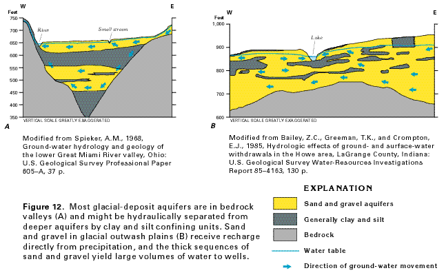
The valley-fill glacial-deposit aquifers (fig. 12A) might be buried beneath till, glacial-lake deposits, or shallower sand and gravel aquifers. Where the bedrock valleys are completely filled, the locations of the ancestral channels and the coarse-grained sediments they contain may not be evident at the land surface. In the example shown in figure 12A, two glacial-deposit aquifers are separated by a clay and silt confining unit that restricts the flow of water between them. The shallower aquifer receives direct recharge from precipitation, and water moves along short flow paths in the aquifer to discharge at local streams. Some water percolates downward through the fine-grained confining unit to recharge the deeper, buried aquifer and moves along more lengthy flow paths before discharging to larger streams. Valley-fill glacial-deposit aquifers in bedrock valleys are much more common than glacial-deposit aquifers in outwash plains.
Aquifers in the sand and gravel of glacial outwash plains (fig. 12B) commonly are exposed at the
land surface and receive direct recharge from precipitation. Water
in the upper parts of these aquifers discharges to local streams,
lakes, or wetlands. Water in the deeper parts of the aquifers,
however, flows beneath the local surface-water bodies and discharges
to large rivers that are regional drains. Lenslike beds of clay
and silt are interspersed with the permeable sand and gravel,
and locally create confined conditions in the aquifers. Large
yields are common from wells completed in aquifers composed of
glacial outwash.
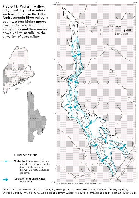
Local movement of water in the glacial valley-fill aquifers generally
is from the valley walls toward streams (fig.
13); regional movement of water is down the valley in the
direction of stream flow. Where these aquifers occupy channels
in permeable bedrock, they generally receive much of their recharge
from the bedrock, but locally discharge some water to it.
Yields of wells completed in the glacial-deposit aquifers formed by continental glaciers are as much as 3,000 gallons per minute where the aquifers consist of thick sand and gravel. Locally, yields of 5,000 gallons per minute have been obtained from wells completed in glacial-deposit aquifers that are located near rivers and can obtain recharge from the rivers. Aquifers that were formed by mountain glaciers yield as much as 3,500 gallons per minute in Idaho and Montana, and wells completed in mountain-glacier deposits in the Puget Sound area yield as much as 10,000 gallons per minute.