
SANDSTONE AQUIFERS
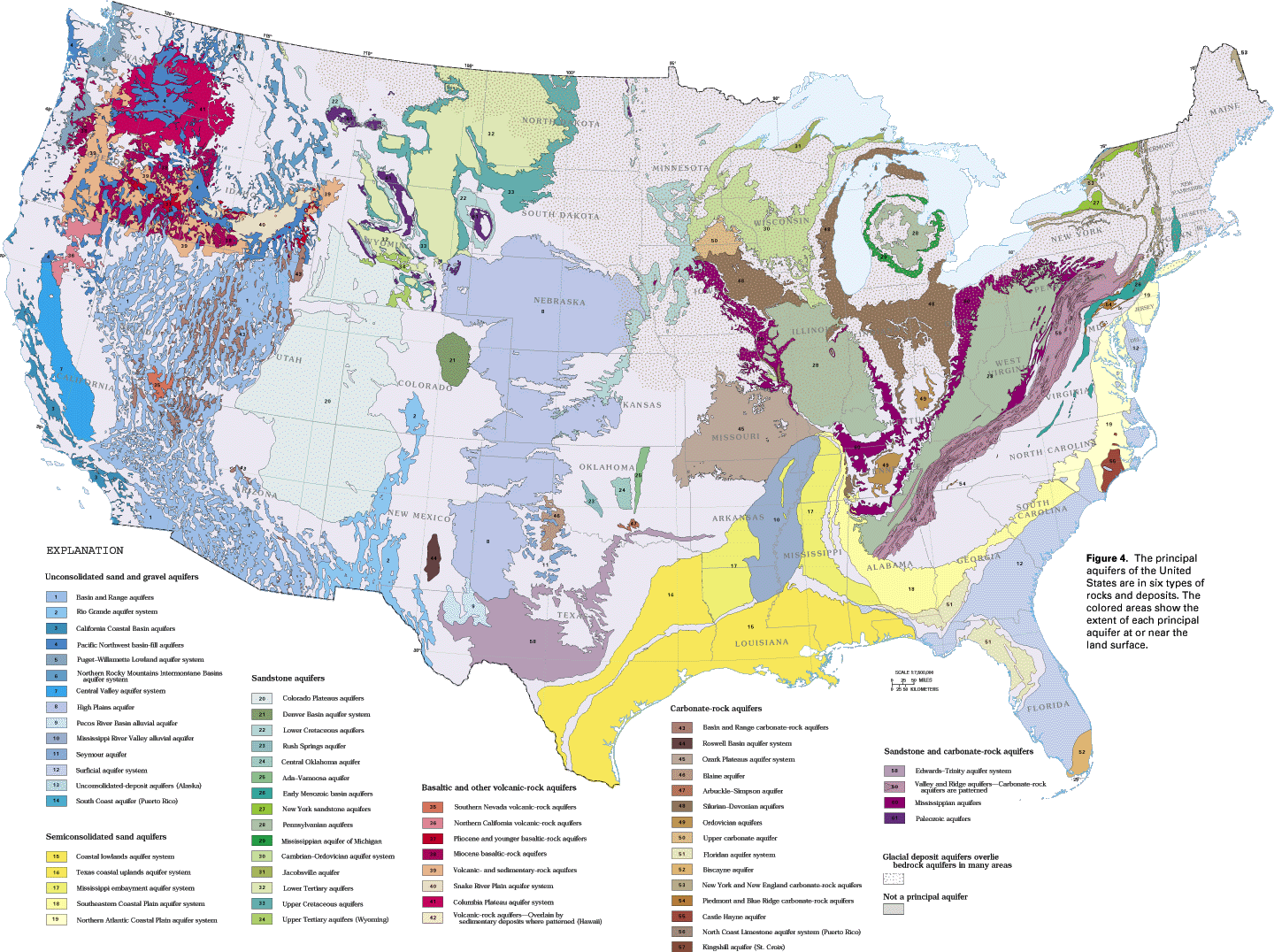
Aquifers in sandstone are more widespread than those in all other kinds of consolidated rocks (fig. 4). Although the porosity of well-sorted, unconsolidated sand may be as high as 50 percent, the porosity of most sandstones is considerably less. During the process of conversion of sand into sandstone (lithification), compaction by the weight of overlying material reduces not only the volume of pore space as the sand grains become rearranged and more tightly packed, but also the interconnection between pores (permeability). The deposition of cementing materials such as calcite or silica between the sand grains further decreases porosity and permeability. Sandstones retain some primary porosity unless cementation has filled all the pores, but most of the porosity in these consolidated rocks consists of secondary openings such as joints, fractures, and bedding planes. Ground-water movement in sandstone aquifers primarily is along bedding planes, but the joints and fractures cut across bedding and provide avenues for the vertical movement of water between bedding planes.
Sandstone aquifers commonly grade laterally into fine-grained, low-permeability rocks such as shale or siltstone. Many sandstone aquifers are parts of complexly interbedded sequences of various types of sedimentary rocks. Folding and faulting of sandstones following lithification can greatly complicate the movement of water through these rocks. Despite all the above limitations, however, sandstone aquifers are highly productive in many places and provide large volumes of water for all uses.
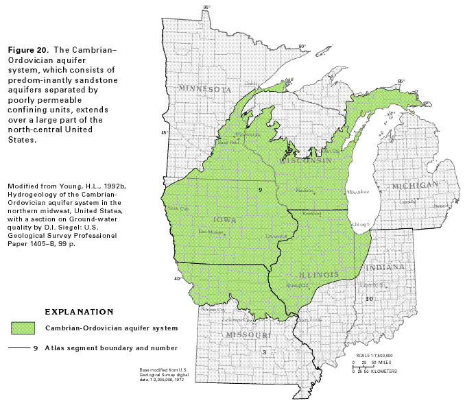
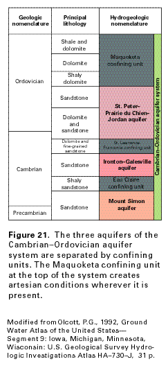
The Cambrian-Ordovician aquifer system in the north-central United States (fig. 20) is composed of large-scale, predominantly sandstone aquifers that extend over parts of seven States and three segments of the Atlas. The aquifer system consists of layered rocks that are deeply buried where they dip into large structural basins. It is a classic confined, or artesian, system and contains three aquifers (fig. 21). In descending order, these are the St. Peter-Prairie du Chien-Jordan aquifer (sandstone with some dolomite), the Ironton-Galesville aquifer (sandstone), and the Mount Simon aquifer (sandstone). The aquifers are named from the principal geologic formations that comprise them. Confining units of poorly permeable sandstone and dolomite separate the aquifers. Low-permeability shale and dolomite compose the Maquoketa confining unit that overlies the uppermost aquifer and is considered to be part of the aquifer system. Wells that penetrate the Cambrian-Ordovician aquifer system commonly are open to all three aquifers, which are collectively called the sandstone aquifer in many reports.
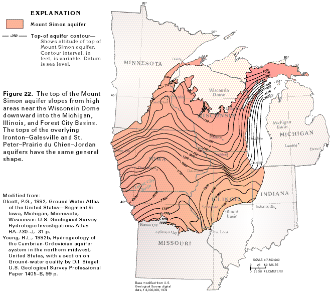
The rocks of the aquifer system are exposed in large areas of northern Wisconsin and eastern Minnesota, adjacent to the Wisconsin Dome, a topographic high on crystalline Precambrian rocks. From this high area, the rocks slope southward into the Forest City Basin in southwestern Iowa and northwestern Missouri, southeastward into the Illinois Basin in southern Illinois, and eastward toward the Michigan Basin, a circular low area centered on the Lower Peninsula of Michigan. The configuration of the top of the Mount Simon sandstone (that forms the Mount Simon aquifer) is shown in figure 22. The map shows that this aquifer, which represents the lower part of the Cambrian-Ordovician aquifer system, is buried to depths of 2,000 to 3,500 feet below sea level in these structural basins. The configuration of the tops of the overlying Ironton-Galesville and St. Peter-Prairie du Chien-Jordan aquifers are similar to that of the Mount Simon aquifer. The deeply buried parts of the aquifer system contain saline water.
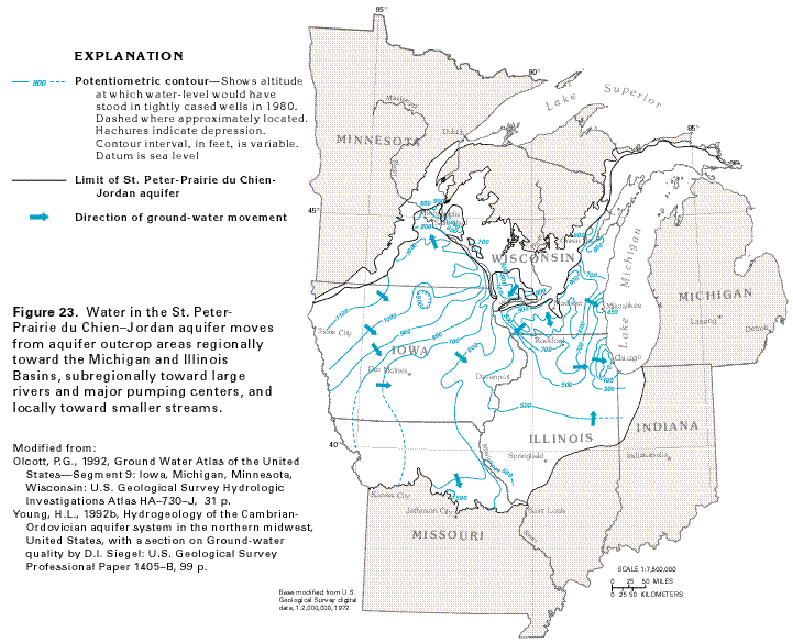
Regionally, water in the Cambrian-Ordovician aquifer system moves from topographically high recharge areas, where the aquifers crop out or are buried to shallow depths, eastward and southeastward toward the Michigan and Illinois Basins. A map of the 1980 potentiometric surface of the St. Peter-Prairie du Chien-Jordan aquifer (fig. 23) shows this general direction of movement. The map also shows that water moves subregionally toward major streams, such as the Mississippi and the Wisconsin Rivers, and toward major withdrawal centers, such as those at Chicago, Illinois, and Green Bay and Milwaukee, Wisconsin. In and near aquifer outcrop areas, water moves along short flow paths toward small streams. Movement of water in the underlying Ironton-Galesville and Mount Simon aquifers is similar to that in the St. Peter-Prairie du Chien-Jordan aquifer. Before development, all the water moved either toward surface streams where it discharged as base flow, or downgradient, toward the structural basins, into deeply buried parts of the aquifer where it discharged by upward leakage into shallower aquifers.
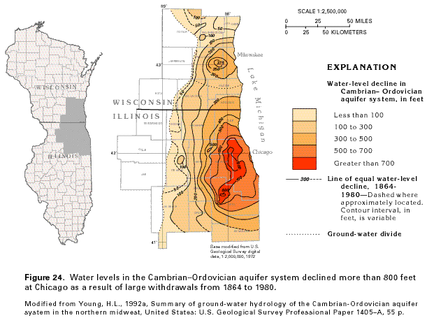
One of the most dramatic effects of ground-water withdrawals known in the United States is shown in figure 24. Withdrawals from the Cambrian-Ordovician aquifer system, primarily for industrial use in Milwaukee, Wisconsin, and Chicago, Illinois, caused declines in water levels of more than 375 feet in Milwaukee and more than 800 feet in Chicago from 1864 to 1980. Many of the wells in the Chicago-Milwaukee area obtain water from all three aquifers of the aquifer system, and the water-level decline map, accordingly, is a composite map that shows the effects of withdrawals on the entire system. The declines extended outward for more than 70 miles from the pumping centers in 1980. Movement of water in the aquifers was changed from the natural flow direction (eastward toward the Michigan Basin) to radial flow toward the pumping centers. Beginning in the early 1980's, withdrawals from the Cambrian-Ordovician aquifer system decreased as some users switched to Lake Michigan as a source of supply. Water levels in the aquifer system had begun to rise by 1985 as a result of the decreased withdrawals.
The ground-water flow system of the Cambrian-Ordovician aquifer system is summarized in figure 25. Water from precipitation moves downward through surficial deposits of glacial drift, shallower aquifers, and the Maquoketa confining unit into the St. Peter-Prairie du Chien-Jordan aquifer. Some of the water moves horizontally along short flow paths to local streams, such as the Little Cannon River, where it moves upward to discharge to the streams as base flow. Some water moves in a similar fashion along flow paths of intermediate length and discharges to larger streams, such as the Cannon River. Some of the water continues to percolate downward through successively deeper confining units into successively deeper aquifers. Water in these deeper aquifers moves laterally over long distances and eventually discharges to major rivers, such as the Mississippi River. A small part of the water moves down the regional hydraulic gradient, perpendicular to the plane of the section shown in figure 25 and toward deeply buried parts of the aquifer system. This deep, regional flow discharges by upward leakage to shallower aquifers or is captured by pumping wells.
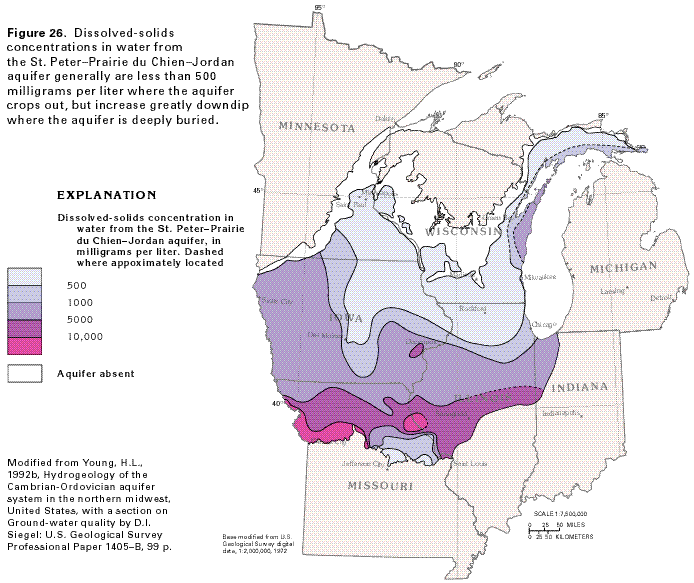
The chemical quality of the water in large parts of the aquifer system is suitable for most uses. The water is not highly mineralized in areas where the aquifers crop out or are buried to shallow depths, but mineralization generally increases as the water moves downgradient toward the structural basins. The distribution of dissolved-solids concentrations in the St. Peter-Prairie du Chien-Jordan aquifer (fig. 26) shows this increase. Where the aquifer is at or near the land surface in southeastern Minnesota, northeastern Iowa, southern Wisconsin, the Upper Peninsula of Michigan, and central Missouri, it contains water with dissolved-solids concentrations of less than 500 milligrams per liter (the limit recommended for drinking water by the U.S. Environmental Protection Agency) or less. Concentrations increase to more than 1,000 milligrams per liter in western and southern Iowa, north-central Illinois, and along the northwestern shore of Lake Michigan. Where the aquifer is deeply buried and ground-water movement is almost stagnant in parts of Missouri, concentrations are greater than 10,000 milligrams per liter. The lobe of water with low dissolved-solids concentrations that extends southward in central Iowa is thought to represent unflushed subglacial meltwater that moved into the aquifer during the Pleistocene Epoch from an area of extremely high hydraulic head created by the weight of the glacial ice. Dissolved solids in water from the Mount Simon aquifer show the same trends as those in water from the St. Peter-Prairie du Chien-Jordan aquifer.
Other layered sandstone aquifers that are exposed adjacent
to domes and uplifts or that extend into large structural basins
or both are the Colorado Plateaus aquifers, the Denver Basin aquifer
system, the lower Tertiary aquifers, the Upper Cretaceous aquifers,
the Lower Cretaceous aquifers, the Wyoming Tertiary aquifers,
the Mississippian aquifer of Michigan, and the New York sandstone
aquifers (fig. 4). The Rush Springs,
Central Oklahoma, and Ada-Vamoosa aquifers of Oklahoma are
small aquifers that contain water largely under unconfined conditions
and generally yield small amounts of water. The Jacobsville aquifer
on the Upper Peninsula of Michigan is also small, mostly unconfined,
and yields little water; however, the glacial deposits that cover
this aquifer store precipitation and release it slowly into the
underlying sandstone. The Pennsylvanian aquifers that cover large
parts of the east-central United States cap hills and plateaus,
are poorly permeable, and yield water mostly from shallow fracture
systems and interbedded, cleated coals. The early Mesozoic basin
aquifers of the eastern part of the Nation occupy titled grabens
or half-grabens, are commonly interbedded with fine-grained sediments
and intruded by traprock, and generally yield only small amounts
of water.