
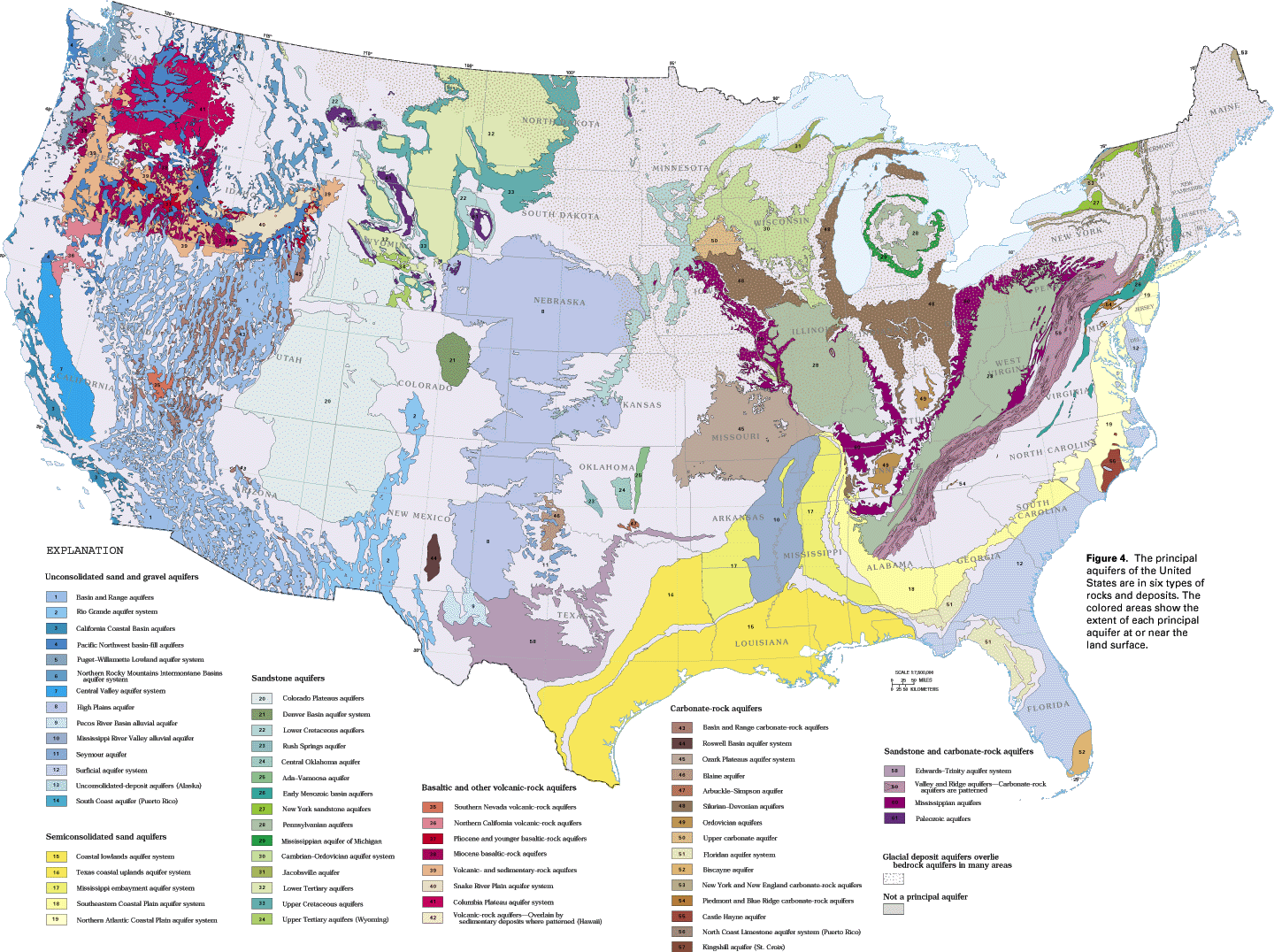
SANDSTONE AND CARBONATE-ROCK AQUIFERS
Aquifers in sandstone and carbonate rocks are most widespread in the eastern half of the Nation, but also extend over large areas of Texas and smaller areas in Oklahoma, Arkansas, Montana, Wyoming, and South Dakota (fig. 4). These aquifers consist of interbedded sandstone and carbonate rocks; the carbonate rocks are the most productive aquifers, whereas the interbedded sandstones yield less water. The aquifers in the Mammoth Cave area of Kentucky are examples of sandstone and carbonate-rock aquifers. The development of solution openings and karst topography in the limestones of the Mammoth Cave area are discussed in the preceding section of this report; the following section discusses the relations of the sandstone and carbonate-rock aquifers in that area.
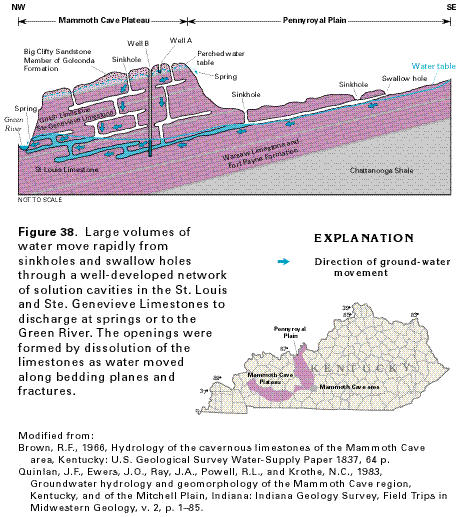
Movement of water through the unconfined and confined parts of the limestone aquifers that underlie the Pennyroyal Plain and Mammoth Cave Plateau is summarized in figure 38. Where the St. Louis Limestone is exposed at the land surface in the Pennyroyal Plain, water from surface streams enters underground solution cavities through swallow holes and sinkholes. Water also enters solution cavities in the Ste. Genevieve and Girkin Limestones through sinkholes that have developed in the Big Clifty Sandstone Member of the Golconda Formation that caps the Mammoth Cave Plateau. The sinkholes on the plateau are collapse sinkholes that developed when the sandstone cap collapsed into caves which formed in the underlying limestone. Many of the solution openings in the Girkin and Ste. Genevieve Limestones are dry because they formed when the erosional base level in the area was at a higher altitude. Water from the saturated solution openings in the Ste. Genevieve and St. Louis Limestones discharges to the Green River from springs in the river channel and valley walls. Large quantities of water move rapidly to the river through the solution openings.
Water moves slowly through intergranular pore spaces and small fractures in the Big Clifty Sandstone Member of the Golconda Formation. Discontinuous layers of shale in the underlying Girkin Limestone (fig. 38) impede the downward movement of water and create a perched water table from which small springs discharge at the escarpments bounding the Mammoth Cave Plateau.
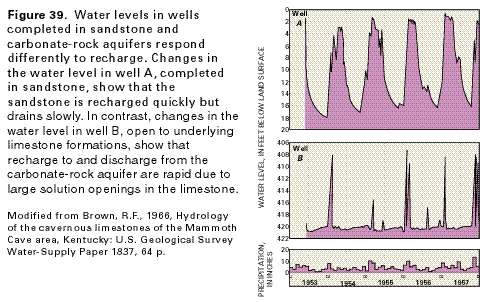
The presence or absence of solution openings affects aquifer
recharge and discharge and is reflected by the water levels in
wells completed in different rock types. The water level in well
A (fig. 39A), completed in the Big
Clifty Sandstone Member of the Golconda Formation (fig.
38), rises quickly in response to seasonal increases in precipitation;
after the sudden rise, the water slowly drains from the aquifer
and the water level declines slowly. In contrast, the water level
in well B (fig. 39B), which is open
to the St. Louis and Ste. Genevieve Limestones, rises sharply
only in response to heavy rains. Following the abrupt rise, the
water level in this well declines quickly as the solution cavities
penetrated by the well are drained. The large openings allow rapid
recharge and equally rapid discharge during and immediately following
periods of intense precipitation. The transmissivity (rate at
which water moves through an aquifer) of the part of the rock
that contains solution openings is extremely high, whereas that
of the undissolved rock between the solution conduits generally
is very low.