INTRODUCTION
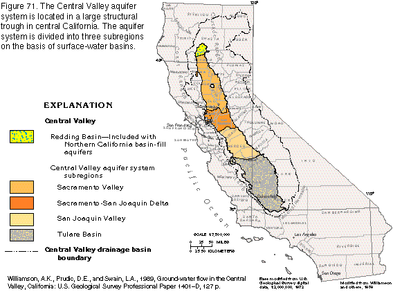
The Central Valley of California (fig. 71) contains the largest basin-fill aquifer system in Segment 1. The valley is in a structural trough about 400 miles long and from 20 to 70 miles wide and extends over more than 20,000 square miles. The trough is filled to great depths by marine and continental sediments, which are the result of millions of years of inundation by the ocean and erosion of the rocks that form the surrounding mountains. Sand and gravel beds in this great thickness of basin-fill material form an important aquifer system. From north to south, the aquifer system is divided into the Sacramento Valley, the SacramentoSan Joaquin Delta, and the San Joaquin Valley subregions, on the basis of different characteristics of surface-water basins.
The Central Valley is one of the most important agricultural areas in the world. No single region of comparable size in the United States produces more fruits, vegetables, and nuts. More than 7 million acres are currently (1995) under irrigation. During 1985, crop irrigation accounted for 96 percent of the surface water and 89 percent of the ground water withdrawn in the Central Valley.
Discovery of gold in the Sierra Nevada and the subsequent proliferation of hydraulic mining operations provided the impetus for the construction of a surface-water diversion system that consisted of hundreds of miles of canals used to transport water to where it was needed for gold-washing operations. This was the beginning of the valley's modern-day aqueduct system, which has become vital to the agricultural economy.
Fertile soil, favorable climate, abundant water, and rapid population growth in the Central Valley encouraged the development of agriculture, which soon became one of the major industries of California. Surface water satisfied most irrigation needs until the late 19th century, when a rapid increase in irrigated acreage produced a demand for water that exceeded the surface-water supply, and ground-water supplementation became necessary; the drought of 1880 was a major stimulus for ground-water development. Wells were used to supplement less dependable surface-water supplies and to provide water where surface-water diversion canals had not been constructed. Shallow ground water was obtained easily in 1880, and artesian pressure was sufficient to produce flowing wells in much of the valley. After 1900, ground water gradually became a more significant part of the total irrigation supply and, eventually, the large number of wells reduced artesian pressure to such an extent that it became necessary to install pumps in order to obtain water.
The invention of the deep-well turbine pump around 1930 allowed withdrawals from greater depths, which encouraged further development of ground-water resources for irrigation. Withdrawals increased sharply during the 1940's and 1950's, and averaged about 11.5 million acre-feet per year by the 1960's and 1970's, which was approximately 20 percent of the total irrigation withdrawals for the United States at that time. Withdrawals reached a maximum of 15 million acre-feet per year during 1977, a drought year. During the 1960's and 1970's, withdrawals greatly exceeded recharge, and water levels declined precipitously, as much as 400 feet in places. The declines caused a major reduction in the amount of ground-water in storage and resulted in widespread land subsidence, mainly in the western and southern parts of the San Joaquin Valley.
Increased rainfall and construction of additional surface-water delivery systems halted most of the serious water-level declines after 1977, and water levels recovered to pre-1960 levels. The network of aqueducts in the Central Valley is currently (1995) sufficient to provide one-half or more of the water needed for irrigation in years of average or above-average precipitation. In dry years, however, reliance on ground-water supplies is greater, and aquifers might again be subject to withdrawals in excess of recharge during a severe drought, such as that of 197677.
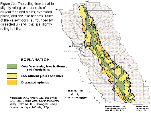
The Central Valley is bounded on the west by the Coast Ranges and on the east by the Cascade Range and the Sierra Nevada. The valley has only one surface-water outlet, the Carquinez Strait east of San Francisco Bay. Much of the valley is surrounded by dissected uplands formed by erosion of coalesced alluvial fans at the base of the mountains (fig. 72) where the terrain ranges from hilly to slightly rolling. The valley floor, which consists primarily of alluvial deposits and flood-plain deposits of the major rivers, is relatively flat to gently rolling and is generally below an altitude of 500 feet. Lake beds in the southern end of the valley become partially to completely flooded in wet years. A prominent feature, Sutter Buttes, which is the remnant of a volcanic plug, rises nearly 1,500 feet above the valley floor in the central Sacramento Valley.
The Sacramento River drains the northern end of the Central Valley, and the San Joaquin River drains much of the middle third. The two rivers join in the SacramentoSan Joaquin Delta and empty into the upper end of San Francisco Bay. The southern end of the valley is occupied by the Tulare Basin, in which drainage is completely internal and the inflowing water is removed by evapotranspiration.
The climate of the Central Valley is Mediterranean and Steppe, characterized by hot summers and mild winters, thus allowing for a year-around growing season; at least one crop is under cultivation at all times. About 85 percent of the precipitation falls from November to April. Most of the precipitation that falls on the valley floor evaporates before it can infiltrate downward to become recharge. Much of the moisture that moves inland from the Pacific Ocean is intercepted by the Coast Ranges, so that annual precipitation in the valley is relatively low. Annual precipitation decreases from north to south, with an average of about 23 inches in the northern part of the Sacramento Valley, to about 6 inches in the southern part of the San Joaquin Valley. Rainfall amounts vary greatly from year to year. Annual precipitation is exceeded by potential evapotranspiration throughout the entire valley, which causes a net annual moisture deficit.
In contrast, the mountains that surround the Central Valley
intercept moisture from eastward-moving weather systems and have
an annual surplus of moisture in the form of rain and snow. Precipitation
can exceed 80 inches annually in the Sierra Nevada. Annual runoff
from rainfall and snowmelt is approximately 32 million acre-feet;
most of the runoff originates in the Cascade Range and the northern
Sierra Nevada (fig. 73). This water
flows to the valley in perennial streams and provides nearly all
the average annual 12 inches of recharge the valley aquifer system
receives. Runoff from the Coast Ranges is principally on the western
slopes to the Pacific Ocean.
GEOLOGIC SETTING
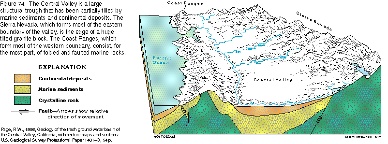
The Central Valley and surrounding area is the product of a complex
series of geologic events. The surrounding area has undergone
mountain building, faulting, and erosion, and the valley has been
inundated several times by the Pacific Ocean.
The Sierra Nevada, which forms the eastern side of the valley, is the eroded edge of a huge tilted block of crystalline rock that also partially defines the base of the valley sediments (fig. 74). Embedded in the granite and related plutonic rocks of the mountains are metamorphosed sedimentary and volcanic rocks of Ordovician to Late Jurassic age. The uplift that formed the Sierra Nevada probably took place between Late Jurassic and Late Cretaceous time.
The northeast corner of the basin is the southern terminus of the Cascade Range. This is an area of lava plateaus and volcanos, some of which have been active in modern times. Geologically, this area of the basin is relatively young; most of the volcanic activity was during late Tertiary to Holocene time.
The northwest corner of the Central Valley is bounded by metamorphosed volcanic rocks of Paleozoic and Mesozoic age. These rocks form a minor part of the valley boundary. The western side of the valley is bounded by the Coast Ranges, which are formed primarily of folded and faulted marine sedimentary rocks of Mesozoic age, which were uplifted during Tertiary time. Mesozoic marine sedimentary rocks and continental deposits underlie the Tehachapi Mountains that bound the valley to the south.
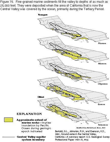
A huge volume of sediments, which is as thick as about 50,000 feet in the Sacramento Valley and about 32,000 feet in the Tulare Basin, fills the Central Valley. These sediments are marine and continental in origin; the marine sediments are the product of deposition during inundations by the Pacific Ocean, and the continental sediments were derived by erosion of the rocks that formed the surrounding mountains.
The ancestral Central Valley was, at least in part, inundated by the Pacific Ocean until 2 million to 3 million years ago. The location, depth, and age of marine sediments in the valley indicates that nearly the entire valley was covered by the sea during Paleocene and Eocene time (fig. 75). As sea level declined, the area covered by the ocean decreased until only the southern end of the basin was still under water in Pliocene time. During Pleistocene and Holocene time, the sea completed its retreat, and all oceanic deposition ceased. In total, the ocean left behind deposits that ranged in thickness from about 25,000 feet in the Sacramento Valley to about 20,000 feet in the San Joaquin Valley. These deposits are mostly consolidated and have minimal permeability.
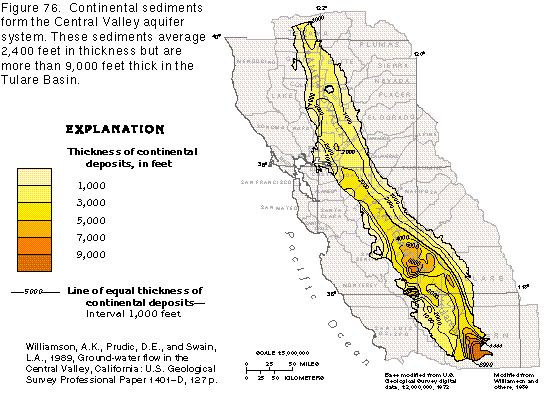
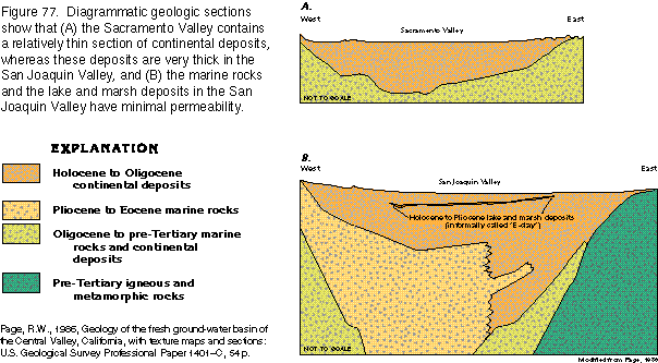
From the time when the valley first began to form, sediments derived from erosion of igneous and metamorphic rocks and consolidated marine sediments in the surrounding mountains have been transported into the valley by streams. These continental sediments are as thick as 9,000 feet at the southern end of the valley and have an average thickness of about 2,400 feet (fig. 76). The continental sediments consist mostly of fluvial, basin-fill, or lake deposits of sand and gravel interbedded and admixed with clay and silt (fig. 77). Depending upon location, deposits of fine-grained materials-mostly clay and silt-make up as much as 50 percent of the thickness of the valley-fill sediments.
Drainage Basins
Three hydrologic subregions coincide with drainage basins within
the Central Valley (fig. 71). These
subregions are hydraulically connected and compose the Central
Valley aquifer system and associated surface-water drainages.
The northernmost subregion is the Sacramento Valley, which extends
over the northern one-third of the Central Valley and is drained
by the Sacramento River. Although the Redding Basin extends over
about 500 square miles at the northern end of the Sacramento Valley
and is a topographic extension of the valley, it is not included
as part of the Central Valley aquifer system because of its separate
ground-water flow system. Adjoining the Sacramento Valley to the
south is the SacramentoSan Joaquin Delta subregion, where
a network of meandering channels has formed at the junction of
the Sacramento and the San Joaquin Rivers. The southernmost subregion
is the San Joaquin Valley, which extends over two-thirds of the
Central Valley. The San Joaquin River drains the northern part
of the San Joaquin subregion; the southern part, which is called
the Tulare Basin, is characterized by interior drainage. The Tulare
Basin is named for Tulare Lake, a lake that covered much of the
basin during the Pleistocene Epoch.
Under natural, or predevelopment, conditions, recharge from rainfall and snowmelt entered the aquifer system as seepage from streams that channel runoff from the surrounding mountains into the valley. Most recharge is at the margins of the valley, and the ground water moves in the subsurface to lower altitudes and discharges into surface-water bodies that drain each basin.
Aquifers and Confining Units
The consolidated volcanic and metamorphic rocks that surround
and underlie the Central Valley are almost impermeable, and flow
through them is not significant. Little water flows through the
extensive deposits of consolidated marine and mixed marine and
continental sediments that overlie the crystalline rocks (fig. 77) because the permeability of the
deposits is generally minimal. The marine sediments usually contain
saltwater or brine, but near the northwestern, western, and southeastern
margins of the San Joaquin Valley, some freshwater is withdrawn
from these deposits.
The Central Valley aquifer system is formed primarily of sand and gravel with significant amounts of silt and clay, all of which have been eroded mainly from older rocks at the boundaries of the valley. The environments in which the continental sediments were deposited varied, but most were deposited in fluvial environments; however, the deposits contain some lacustrine beds. Locally, volcanic rocks and dune deposits are part of the aquifer system. Specific geologic formations can be related to specific aquifers within the Central Valley aquifer system only with difficulty because many of the formations are lithologically similar, and cannot be distinguished easily in the subsurface.
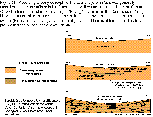
Beds and lenses of fine-grained materials, such as silt and clay, constitute a significant percentage of the Central Valley aquifer system. In most parts of the valley, fine-grained materials compose 50 percent or more of the aquifer system. The most extensive clay bed, which is informally named the "E-clay" (fig. 77), consists primarily of the Corcoran Clay Member of the Tulare Formation and underlies much of the western San Joaquin Valley. Because beds of silt and clay do not readily transmit water under natural conditions, they act as barriers to vertical flow and cause differences in hydraulic head with depth.
Early investigators thought that the Sacramento Valley contained a single unconfined aquifer and that the San Joaquin Valley contained an upper unconfined to semiconfined aquifer separated from a lower aquifer confined by the Corcoran Clay or "E-clay" (fig. 78). However, recent investigations indicate that the Central Valley contains a single heterogeneous aquifer system that contains water under unconfined, or water-table, conditions in the upper few hundred feet; these conditions grade into confined conditions with depth. The confinement is the result of numerous overlapping lens-shaped clay beds. Geophysical well logs indicate that the "E-clay," although probably the largest single confining bed, constitutes only a small percentage of the total thickness of clay layers in the aquifer system. This indicates that the significance of the "E-clay" as a barrier to vertical flow may have been exaggerated. Further, the difference in hydraulic head directly above and below the "E-clay" is small when compared to head differences within intervals of the deep parts of the aquifer system.
GROUND-WATER FLOW SYSTEM
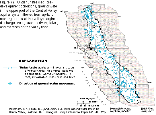
Before development began, the aquifer system was under steady-state
conditions in which natural recharge balanced natural discharge.
Ground water in the shallow part of the aquifer system flowed
from areas of high altitude at the valley margins, where most
of the recharge took place, downgradient to discharge into rivers
and marshes near the valley axis (fig.
79). The aquifer system was recharged primarily by streams
emanating from the Coast and Cascade Ranges and the Sierra Nevada.
Most of the recharge was in the northern and eastern parts of
the valley. Precipitation falling on the valley floor during the
rainy season provided only a small part of the total recharge.
Ground water that was not evaporated or transpired by plants discharged
either into the Sacramento and the San Joaquin Rivers that drained
to San Francisco Bay or into the Tulare Basin from which it was
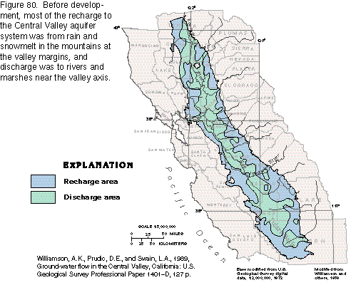
eventually removed by evaporation or transpiration. The areas
of recharge and discharge in the Central Valley before development
are shown in figure 80.
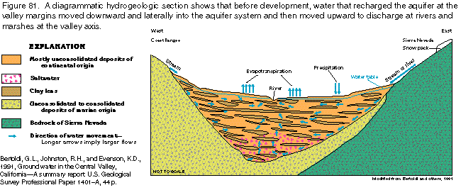
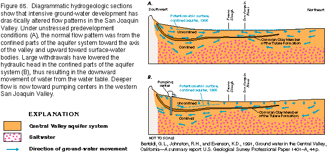
Under predevelopment conditions, the hydraulic head in the shallow water-table aquifer where water entered the aquifer system at the valley margins was greater than the head in the deeper confined aquifer; thus, ground water moved downward (fig. 81). Conversely, the head gradient was reversed where water left the aquifer, typically by discharge to surface-water bodies, and the hydraulic head in the water-table aquifer was less than that in the confined aquifer. The difference in hydraulic head created upward movement of the ground water toward rivers and marshes (fig. 81). Precipitation that fell on the valley floor and was not lost to evapotranspiration recharged the water-table aquifer and moved down the head gradient toward the rivers and surrounding marshes.
Upward vertical flow to discharge areas from the deep confined aquifer was impeded by confining clay beds, which caused a pressure head in the deep parts of the aquifer system. Because of the pressure head, wells that penetrated the deep aquifer in low-lying areas near the rivers and marshes flowed during the early years of ground-water development in the valley.
POSTDEVELOPMENT GROUND-WATER FLOW SYSTEM
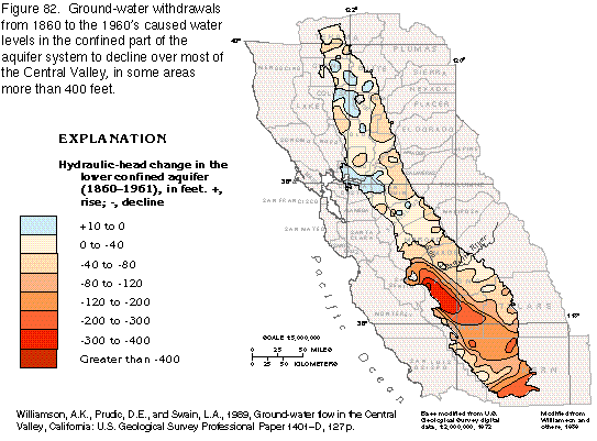
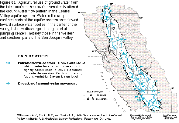
By the early 1960's, intensive ground-water development had significantly
lowered water levels and altered ground-water flow patterns in
the Central Valley aquifer system. By far the most dramatic impact
of development was in the San Joaquin Valley, where water-level
declines in the confined part of the aquifer system were locally
more than 400 feet (fig. 82). Although
predevelopment flow was toward the San Joaquin River throughout
most of the basin, large withdrawals from deep wells in the western
and southern parts of the aquifer system changed the direction
of horizontal flow in the confined part of the system until the
water moved toward the withdrawal centers (fig.
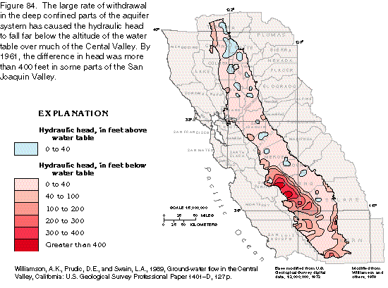
83). Also, because the magnitude of the withdrawals caused
hydraulic heads in the confined parts of the aquifer system to
fall far below the altitude of the water table (fig.
84), the vertical hydraulic gradient was reversed over much
of the San Joaquin Valley. As a result, much of the water in the
upper unconfined zone of the aquifer system that flowed laterally
toward the river under predevelopment conditions leaked downward
through the confining beds into the lower confined aquifer after
development (fig. 85).
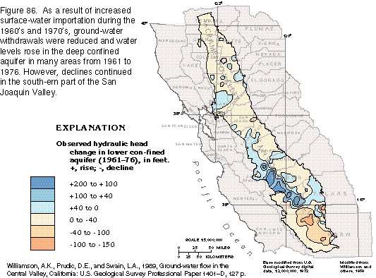
Concurrent with an increase in surface-water imports in the early 1970's, ground-water withdrawals in the northern part of the Central Valley aquifer system decreased, which allowed ground-water levels in many areas to recover in the confined part of the aquifer system (fig. 86), in some cases to pre-1960 levels. However, in the San Joaquin Valley large withdrawals continued, especially in the western and southern parts of the valley, and water levels continued to decline. With few exceptions, the ground-water flow patterns in the aquifer system today (1995) are the same as those in the mid-1970's.
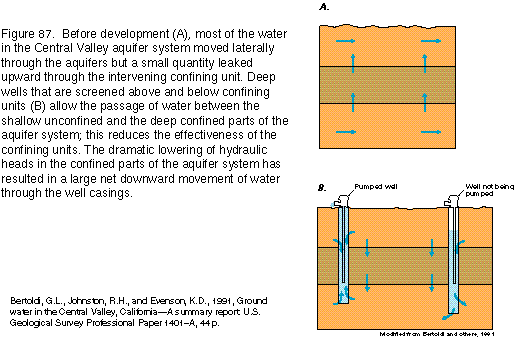
Ground-water development in the San Joaquin Valley has reduced the effectiveness of the confining beds within the aquifer. Thousands of wells with casings perforated for much of their length have been drilled through the clay confining units. Where these wells are open to the unconfined and confined aquifers, they allow virtually unrestricted vertical flow through the well bore (fig. 87). The amount of water that flows downward through one large-diameter well has been estimated to be equivalent to the natural leakage through the "E-clay" over an area of approximately 7 square miles. During the peak of the withdrawal season, the net downward flow may be, on average, as much as 0.3 cubic foot per second per well.
WELL DEPTHS AND YIELDS
Well depths in the Central Valley aquifer system are determined
by the depth of permeable aquifer material and by the quality
of the ground water. In general, wells are usually less than 500
feet deep in the Sacramento Valley but are as deep as 3,500 feet
in the San Joaquin Valley. The greater depth of wells is a result
of the low permeability of the sands in the unconfined aquifer
in the western and southern San Joaquin Valley and of highly mineralized
water and water high in selenium in the upper parts of the aquifer
system in the western San Joaquin Valley.
Well yields of more than 1,000 gallons per minute are commonly obtainable throughout the aquifer system. The average yield of wells in the Sacramento Valley is approximately 800 gallons per minute, but yields as large as 4,000 gallons per minute have been recorded. The average yield of wells in the San Joaquin Valley is about 1,100 gallons per minute, and the maximum expected yield is about 3,200 gallons per minute.
WATER BUDGET OF THE AQUIFER SYSTEM
A water budget is a method of quantitatively accounting for water
movement in a hydrologic system. A computer-simulated approximation
of the annual Central Valley aquifer system water budget under
predevelopment and development conditions is shown in figure
88. The figure depicts only water that circulates through
the aquifer system and does not account for water that enters
the valley but does not interact with the aquifer system. This
excludes most surface-water flow and water that is lost to evaporation
almost immediately after it falls on the valley floor.
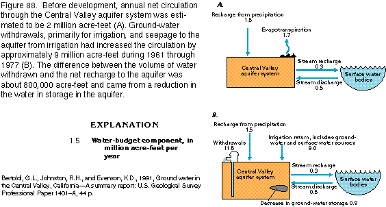
Before development, the net circulation through the aquifer system was approximately 2 million acre-feet per year (fig. 88A). Of an average annual 12.4 million acre-feet of precipitation that fell on the valley floor, 10.9 million acre-feet was lost to evaporation because of the arid conditions that characterize the valley; thus, only 1.5 million acre-feet of precipita-tion entered the aquifer system as recharge. Water that moved from surface-water bodies to the aquifer system provided the remaining 500,000 acre-feet per year of recharge. The recharge was balanced by discharge from the aquifer system to rivers (300,000 acre-feet) and evapotranspiration (1.7 million acre-feet).
Development added two components to the water budget-withdrawals and return flow from irrigation-and increased the volume of water that flowed through the ground-water system approximately sixfold from 1961 through 1977. Ground-water withdrawals for irrigation, municipal supply, and industrial use totaled about 11.5 million acre-feet annually. Seepage from irrigation returned about 9 million acre-feet to the ground-water system (fig. 88B). During the period 1961 through 1977, the rate of ground-water withdrawals from the aquifer system was greater than the net recharge from all sources. Withdrawals in excess of recharge resulted in a loss of water from storage in the aquifer of 800,000 acre-feet per year. In the case of the Central Valley aquifer system, some of the loss from storage is permanent because some of the water was removed from beds of fine-grained materials, which, when drained, become compacted and cannot store water again. Compaction of fine-grained materials led to land subsidence in the Central Valley. By the late 1970's, however, sufficient surface-water supplies were imported by aqueducts to reduce substantially the volume of ground water that was withdrawn. Although some additional surface water has been imported since 1977 and ground-water withdrawals have slightly decreased, the water budget shown in figure 88B is representative of current (1995) conditions.
FRESH GOUND-WATER WITHDRAWALS
Ground-water withdrawal from the Central Valley aquifer system
varies seasonally. The highest demand is generally during the
peak growing season in spring and summer, which are the driest
seasons of the year. Demand for ground water is greatest in the
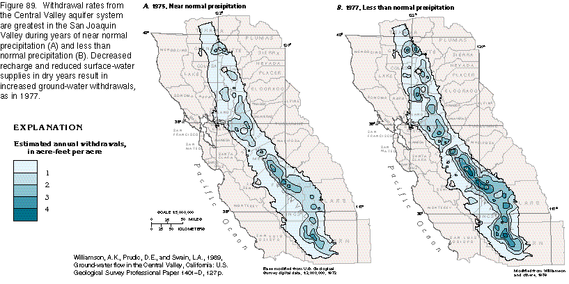
semiarid San Joaquin Valley where natural recharge is least. Withdrawal
rates increase significantly during dry years (fig.
89).
Ground water accounted for only a small part of the water withdrawn for irrigation before 1900. Streams and distribution canals supplied most of the demand. However, the need to con-tinue irrigation in dry years when surface-water supplies are undependable, as well as the expansion of agriculture into areas distant from surface-water sources, prompted increased ground-water development. By the 1960's, ground-water withdrawals from the Central Valley aquifer system averaged 11.5 million acre-feet per year, which was one-half or more of the water withdrawn from all sources (fig. 90) and was about 20 percent of the total irrigation withdrawals for the entire United States. During that same period, withdrawals for domestic and industrial uses accounted for about 5 percent of all ground-water withdrawals in the Central Valley. Historically, the largest withdrawal of ground water-15 million acre-feet-was during 1977, a drought year.
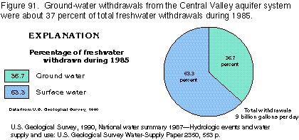
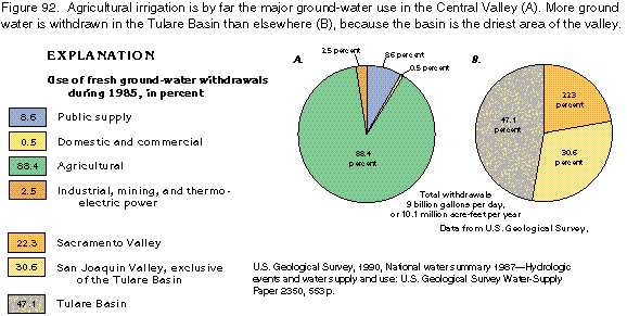
Increased importation of surface water for irrigation since 1977, as well as generally wetter weather through 1985, resulted in decreased ground-water withdrawals. During 1985, ground water accounted for only about 37 percent of the total withdrawals in the Central Valley (fig. 91); total ground-water withdrawals were 10.1 million acre-feet (fig. 92). Of that amount, agricultural withdrawal accounted for 8.8 million acre-feet, all of which was used for irrigation (fig. 92A). This amount was about 11.5 percent of all ground water withdrawn in the United States for all purposes during 1985. The remaining 1.3 million acre-feet was used for public supply and industrial purposes, and by domestic and commercial users. Almost one-half of the water was withdrawn from the Tulare Basin (fig. 92B).
Although gains have been achieved by importing surface water from areas of surplus to areas of deficit, projected water needs in the San Joaquin Valley may require temporary withdrawal of ground water in excess of recharge in the future. The California Department of Water Resources has estimated that by 2010 demand for water in the Sacramento Valley, the San Joaquin Valley (exclusive of the Tulare Basin), and the Tulare Basin would be 7, 8, and 9 percent greater, respectively, than 1980 demands. The Sacramento Valley is expected to have sufficient supplies to meet agricultural demand until at least 2010. However, without increased surface-water imports, the San Joaquin Valley (exclusive of the Tulare Basin) and the Tulare Basin might require withdrawals of 150,000 and 2,400,000 acre-feet per year, respectively, in excess of recharge. Those estimates probably underestimate additional increased demand that would result from sustained dry weather. Occasional large withdrawals from an aquifer are a viable solution to the problem of reduced surface-water supplies in dry periods, provided the aquifer is replenished during wet years. However, continual withdrawal of ground water in excess of recharge can increase the cost of pumping, reduce water availability, and, in certain hydrogeologic settings, can cause land subsidence.
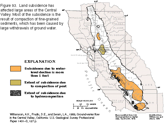
LAND SUBSIDENCE
Land subsidence is widespread in the Central Valley (fig.
93), and has resulted in damage to buildings, aqueducts, well
casings, bridges, and highways; has caused flooding; and has cost
millions of dollars. The three processes that caused most of the
subsidence are oxidation and compaction of peat, hydrocompaction,
and compaction of fine-grained sediments due to withdrawal of
ground water in excess of recharge. Of these, the third process
has caused the most widespread and severe subsidence.
Human-induced subsidence probably began in the middle 1800's when peat soils in marshes of the SacramentoSan Joaquin Delta were first drained for cultivation. In the delta, shallow ground water is drained into ditches to dry the fields before planting and then pumped from the ditches into nearby natural channels. During the growing season, water is siphoned back into the drainage ditches to raise the water table to the root zone. When the peat soils are drained and exposed to the atmosphere they oxidize and compact, and (or) are reduced in thickness by wind erosion; thus, the land surface is permanently lowered with each yearly cycle. To dry the fields each year, the water table must be lowered below that of the previous year, which requires an increase in withdrawals and a decrease in the volume of ground water in storage. Subsidence due to oxidation and compaction of peat soils has lowered the land surface in the delta as much as 6 to 15 feet.
Hydrocompaction is caused when formerly unsaturated soils become saturated, which allows the soil particles to reorient into a more compact form. Irrigation of clayey alluvial-fan soils has resulted in hydrocompaction and subsidence of 3 to 15 feet on the western and southern margins of the San Joaquin Valley (fig. 93). Soils in many areas crossed by the California Aqueduct were intentionally hydrocompacted before aqueduct construction to avoid subsidence problems. Subsequent subsidence due to hydrocompaction in these areas has been minimal.
The primary cause of land subsidence in the Sacramento and the San Joaquin Valleys has been the compaction of fine-grained sediments (predominantly clay) in the aquifer system following severe, long-term withdrawal of ground water in excess of recharge (fig. 93). The amount of such subsidence in an area is related to the amount of withdrawal and the percentage of the withdrawal zone composed of clay beds. Compaction occurs when the hydraulic head in the confined parts of the aquifer system is lowered, thus reducing the hydraulic head in the clay beds, which, in turn, reduces the pore pressure in the clay. The weight of overlying sediments compacts the clay and squeezes water out of the clay until equilibrium is reached with the pore pressure in the clay. Compaction seems to happen more readily when the wells are open only to the confined part of the aquifer system than when they are open to the shallow water-table aquifer as well. When ground water is withdrawn from above and below the confining units, head differential is less between the shallow and deep aquifers and reduction in pore pressure in the clay is less.
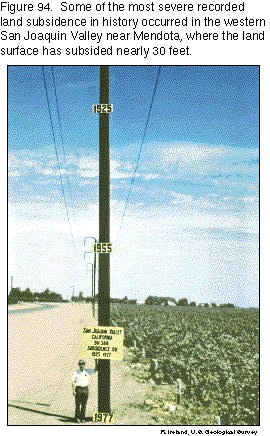
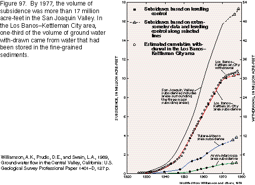
Subsidence due to compaction of fine-grained sediments began in the San Joaquin Valley in the 1920's and in the Sacramento Valley in the 1950's. The area most affected has been in the southern and western parts of the San Joaquin Valley (fig. 93). Approximately one-half of the valley, or about 5,200 square miles, had subsided at least 1 foot by 1977; the total volume of subsidence was greater than 17 million acre-feet. The land surface declined nearly 30 feet from the 1920's to the late 1970's in an area southwest of Mendota (fig. 94). Importation of surface water and reduction in ground-water withdrawals during the 1970's slowed or stopped the decline of ground-water levels. In many cases, this allowed recovery to pre-1960's water levels and prevented further land subsidence.
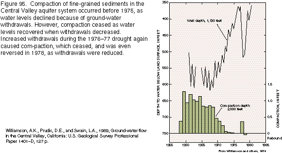
Compaction and declining water levels are directly related (fig. 95). As water levels declined severely during the 1960's, fine-grained sediments lost water from pore spaces and became compacted. When withdrawal rates decreased and water levels were allowed to recover, compaction rates slowed significantly. Increased withdrawals during the 197677 drought caused additional subsidence, some of which was the result of compaction of coarse-grained sediments. When water levels recovered, the fine-grained sediments remained compacted; however, the land surface rebounded in 1978 because the compacted coarse-grained sediments regained some of their original volume when the former or near former pore pressure was attained.
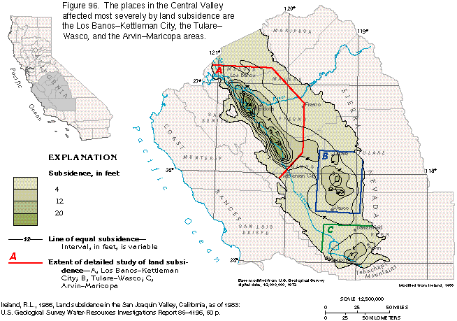
The three areas most affected by subsidence are, in order of total volume of compaction, the Los BanosKettleman City, the TulareWasco, and the ArvinMaricopa areas (fig. 96). The direct relation between withdrawals and subsidence in the Los BanosKettleman City area is apparent in figure 97. Clay has a high percentage of pore space and, when compressed, can yield large amounts of water relative to its volume. Approximately one-third of the withdrawals in the Los BanosKettleman City area were derived from ground water released from clay beds when the clay was compacted.
Because compaction of the clay is permanent, the volume of storage lost because of compaction will not be regained, except for the small amount that was the result of the compaction of coarse-grained aquifer materials. Thus, the land surface cannot rebound to any significant degree, but when the demand for ground water increases because of drought, water levels can be lowered nearly to those of the late 1970's without the threat of additional land subsidence. For example, during the 197677 drought, ground-water withdrawals increased markedly, and water levels declined rapidly. However, from 1968 to 1976, water levels had risen to such an extent that hydraulic heads remained above the extremely low levels of the 1960's. Compaction occurred only in the sand and gravel and was relatively insignificant and, to a degree, reversible (fig. 95).
GROUND-WATER QUALITY
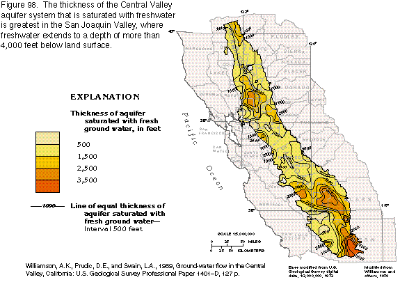
The thickness of aquifer saturated with freshwater (water with
less than 1,000 milligrams per liter dissolved-solids concentration)
in the Central Valley aquifer system varies greatly (fig.
98) and depends, for the most part, on the depth to and permeability
of the rocks that underlie continental deposits. In the Sacramento
Valley, the base of freshwater generally coincides with the base
of continental deposits. The several isolated lenses of saline
water that are within the freshwater zone may be evaporation residues
or estuarine water that was trapped by subsequent sedimentation.
The depth to the base of freshwater is as much as 2,500 feet in
the Sacramento Valley.
In the San Joaquin Valley, the pattern is more complex. Freshwater is mainly in continental deposits, but also is in Tertiary marine rocks on the southeastern side of the valley and in pre-Tertiary igneous and metamorphic rocks. However, sediments of continental origin are the primary source of freshwater. The thickness of aquifer saturated with freshwater in the San Joaquin Valley ranges from 100 to more than 4,000 feet (fig. 98).
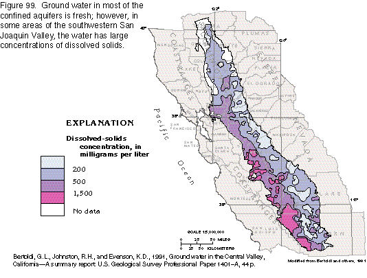
Freshwater is available throughout most of the Central Valley. The concentration of dissolved solids in the ground water reflects the general chemical character of water in the streams that recharge the aquifer system. Dissolved-solids concentrations in the streams, in turn, are directly related to the type of rocks that form the mountains in which the streams rise. Stream water from the Cascade Range and the Sierra Nevada, which are underlain primarily by igneous rocks, has much smaller dissolved-solids concentrations than water from the Coast Ranges, which are underlain by marine sedimentary rocks. Thus, ground water in the Sacramento Valley and the east side of the San Joaquin Valley has generally smaller dissolved-solids concentrations than water from wells on the west side of the valley (fig. 99).
In general, dissolved-solids concentrations increase with depth in the Central Valley aquifer system. Therefore, the generally deeper wells in the western and southern parts of the San Joaquin Valley are likely to produce water with larger dissolved-solids concentrations than the generally shallower wells in the Sacramento Valley and the eastern part of the San Joaquin Valley.
Ground water in agricultural areas can become excessively saline and damaging to crops because evaporation of sprayed irrigation water and evapotranspiration of soil moisture and shallow ground water leaves behind dissolved salts. As a result, the concentration of salts in the soil and shallow ground water increases and may reach levels detrimental to plant growth. Shallow irrigation wells worsen the problem by recir-culating the saline shallow ground water, thus accelerating the process. The only remedy for this problem is to provide subsurface drainage to remove the shallow saline ground water.
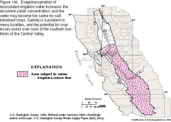
The potential for crop damage due to saline irrigation-return flow is widespread in the SacramentoSan Joaquin Delta and the San Joaquin Valley (fig. 100). Although several individual irrigation return-water drainage systems are operated, no current (1995) valleywide system removes shallow saline ground water. An estimated 400,000 to 700,000 acres of arable land may be lost by 2010 because of increasing soil and water salinity with an accompanying loss of from $32 million to $320 million annually.
Soils on the western side of the San Joaquin Valley are derived primarily from the marine rocks that form the western boundary of the aquifer system and contain relatively large amounts of selenium, which also is in ground water in the marine rocks and is concentrated in the soil by evapotranspiration. Excess irrigation water applied to leach salts from the soil, thus preventing salt buildup, leaches selenium from the soil and the marine rocks and transports it to shallow ground water or surface drains. Water that contains dissolved-selenium concentrations of 1,400 micrograms per liter is in some of the regional surface drains, and a concentration of 4,200 micrograms per liter was reported in water from the drainage system on one farm. Concentrations of dissolved selenium as large as 3,100 micrograms per liter have been detected in shallow ground water in the western part of the San Joaquin Valley; the largest concentrations are west of the San Joaquin River flood plain.
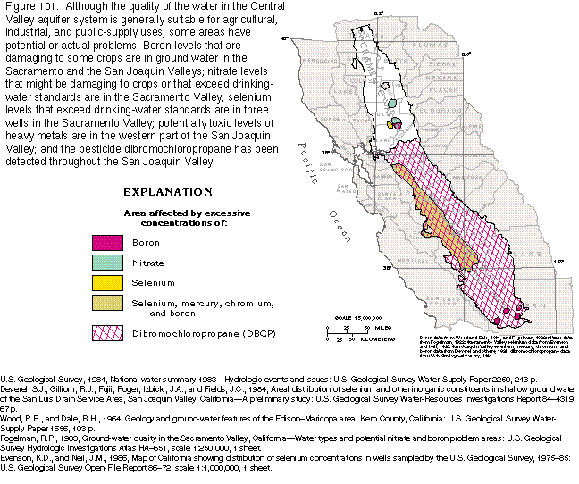
Although large local concentrations of selenium are in the western part of the San Joaquin Valley, evidence that drinking-water supplies in the Central Valley are currently (1995) at serious risk because of selenium contamination is lacking. The large selenium concentrations in the western part of the San Joaquin Valley are known only to be in the shallow ground water and not in the deeper parts of the aquifer system from which most wells that supply municipalities obtain water. A 1986 survey of wells outside of the western part of the San Joaquin Valley indicated selenium concentrations to be larger than 10 micrograms per liter in water from only 3 of 113 wells sampled in the Central Valley (fig. 101).
Boron is an essential micronutrient but may be toxic to sensitive plants in concentrations as low as 0.5 milligram per liter. Currently (1995), the U.S. Environmental Protection Agency has no standards for boron in drinking water. Boron is found in concentrations potentially harmful to plants in the northern and southwestern parts of the Sacramento Valley and in the Tulare Basin in the extreme southern part of the San Joaquin Valley (fig. 101). Large concentrations of boron also have been detected in shallow ground-water in the western part of the San Joaquin Valley. Chromium and mercury have been detected in shallow ground water in the western part of the San Joaquin Valley at levels that exceed U.S. Environmental Protection Agency standards for protection of aquatic life.
Excessive concentrations of nitrate in water are potentially harmful to infants and young children, and the maximum recommended for drinking water by the U.S. Environmental Protection Agency is 10 milligrams per liter. Some crops may be affected by nitrate concentrations as low as 5 milligrams per liter. During a survey conducted in 1983, nitrate levels in ground water were found to exceed 10 milligrams per liter in three areas in the Sacramento Valley (fig. 101). The contaminated wells were shallow, and the source of nitrate pollution was attributed to effluent from waste-treatment facilities, discharge from septic tanks, or leaching of nitrogen fertilizers. Occurrences of nitrate in concentrations of greater than 5 milligrams per liter are sporadic in the San Joaquin Valley and seem to be confined mainly to the shallow parts of the aquifer. The contamination is usually attributable to local sources, such as septic tanks, feed lots, and dairies.
Agricultural use of pesticides is widespread in the Central Valley. Dibromochloropropane (DBCP), which is a potential carcinogenic nematocide, is in ground water in every county in the San Joaquin Valley (fig. 101), and has been detected in 2,522 of 8,190 private and public-supply wells sampled from 1979 through 1984; in California, DBCP has been outlawed from use since August 1977. At least 50 other pesticides, including 1,2dichloropropane and ethylene dibromide, had been detected in ground water in the Central Valley by 1984.