INTRODUCTION
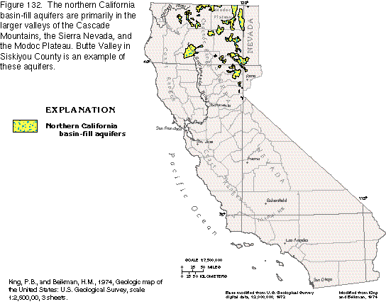
The northern California basin-fill aquifers comprise an assemblage of intermontane aquifers in northern California (fig. 132) that have similar hydrogeologic characteristics. These basins are much like the Coastal Basins aquifers in that the principal water-yielding deposits are unconsolidated sediments of Quaternary age, but the geologic history of the basin-fill aquifers is different.
The valleys are located mostly in the Cascade Mountains, the northern Sierra Nevada, and the Modoc Plateau. All the valleys are drained by tributaries or the main stems of the Klamath and the Sacramento Rivers. The primary land uses in these sparsely populated valleys are agriculture and grazing; some land is devoted to timber.
Climate among the valleys varies with altitude and distance from the Pacific Ocean. Generally, the valleys nearest the ocean and at lower altitudes have a moderate climate. Precipitation amounts vary with altitude and local physiography. The average annual precipitation ranges from less than 20 inches in Butte Valley near the Oregon border to as much as 80 inches in some valleys of the Sierra Nevada.
The most common use of water withdrawn from the northern California alluvial-valley aquifers is irrigated agriculture. Surface water provides the largest source of supply, but ground water is a significant percentage of the total water withdrawn, especially in dry years. Municipal and industrial supplies in most of the valleys depend primarily on ground water. Because ground-water withdrawals currently (1995) do not exceed natural recharge in these valleys, additional development is possible.
The complex geologic history of northern California is characterized by extreme tectonic and volcanic activity. The oldest exposed rocks date from the middle part of the Paleozoic Era and are in the Salmon and the Cascade Mountains and the Sierra Nevada. Mesozoic marine rocks also are in these mountains; for the most part, these rocks are metamorphosed sedimentary and volcanic rocks. The lithology of the rocks in these areas provides evidence of an ocean that once extended much farther inland than does the modern Pacific Ocean and a subduction zone that was located as far east as the Sierra Nevada, which predominately consists of granitic intrusive rocks. Mesozoic intrusive rocks also make up part of the Sierra Nevada.
The valleys in the interior of northern California are in structural troughs or depressions that resulted from the folding and faulting of crystalline rock. The troughs are partly filled with permeable sediments, principally of Pleistocene and Holocene age, that were eroded from the mountains and deposited as alluvial fans or lake deposits, or both. In some of the basins in the Cascade Mountains, volcanism produced basalt, pyroclastic flows, and tuffs that were deposited along with the basin-fill sediments. These volcanic and pyroclastic rocks were subsequently covered with alluvial material. The maximum thickness of unconsolidated permeable deposits in the valleys ranges from approximately 300 to 1,700 feet.
Ground water in the valleys is contained mostly in the alluvial-fan and lake deposits that fill the basins. Small to large amounts of ground water are stored in fractures and joints of volcanic rocks. In some basins, however, volcanic rocks store, transmit, and yield large amounts of water. Whether the ground water is under unconfined to confined conditions depends upon depth and the amount of fine-grained materials.
The aquifers are recharged by runoff from the surrounding mountains, seepage from streams, precipitation on the valley floor, irrigation return, or subsurface flow through fractured crystalline rocks. Ground water leaves the valleys by evapotranspiration, as stream discharge in the valleys that are drained by rivers, and, in some cases, by subsurface flow through permeable bedrock.
Well depths vary among the valleys, but most wells are from 50 to 500 feet deep; those completed in volcanic rock, however, can exceed 1,300 feet in depth. Well yields vary widely, and depend on the permeablilty of the water-yielding material in which the well is completed. Yields range from less than 100 gallons per minute in alluvial-fan and lake deposits to as much as 5,000 gallons per minute in intensely fractured volcanic rocks.
Although isolated areas have highly mineralized water, ground water suitable for most uses is widely available in these valleys. Locally, some of the water contains objectionable quantities of sodium or sulfate.
BUTTE VALLEY
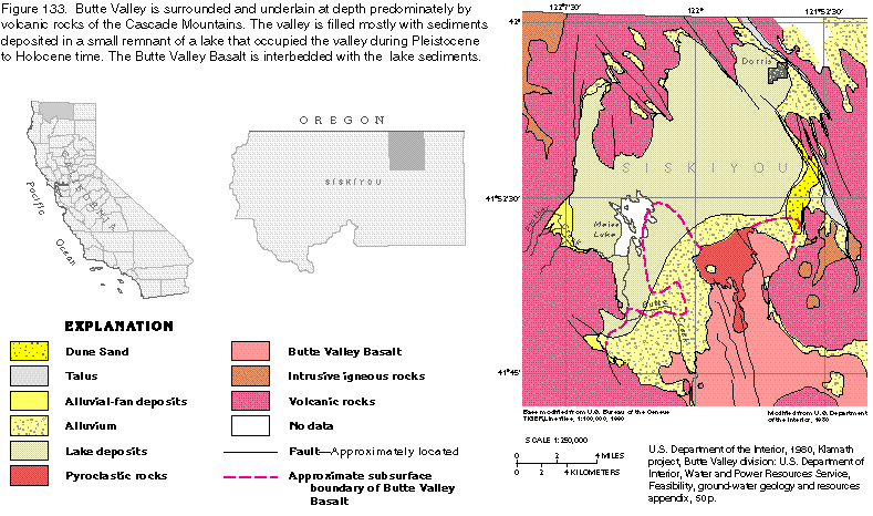
Butte Valley, which contains one of the more intensively developed aquifers of the northern California basin-fill aquifers, is located in north-central California just south of the Oregon border (fig. 132). The valley is one of several intermontane basins in northern California that is filled with alluvial deposits or lake deposits, which are a major source of ground water. However, Butte Valley is unique in that fractured volcanic rocks that underlie the basin fill and basalt interbedded with the basin fill also are major sources of water. Population in the valley is small, and irrigated agriculture accounts for most ground-water use.
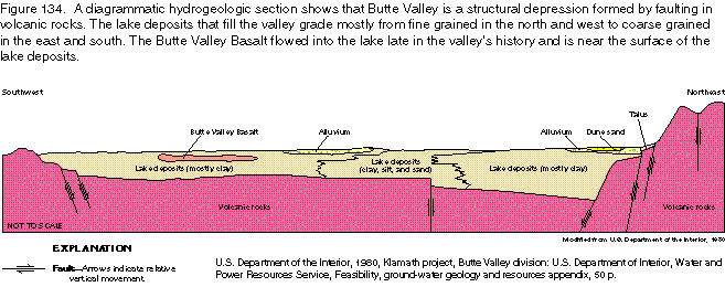
Butte Valley, which was formed by faulting, is a closed basin approximately 18 miles long from north to south and has a maximum width of 13 miles (fig. 133). The valley floor is an ancestral lake bed that encompasses an area of about 130 square miles. Volcanic rocks surround the valley and underlie it at depths of about 400 to 1,500 feet (fig. 134). Streams drain into the valley from the west, and the water either infiltrates permeable deposits or flows into Meiss Lake (fig. 133), which is a small remnant of the large lake that once filled the valley. Discharge from the valley is by subsurface flow through fractured volcanic rocks to adjacent basins.
The valley floor receives approximately 12 inches of precipitation annually as rain or snow, mostly from October to June. The basinwide average is about 18 inches, but as much as 40 inches falls at the higher altitudes. Summers in the valley are warm and dry, and winters are cool and humid.
Aquifers and Confining Units
The major rocks and deposits that yield water to wells in the
valley are the Butte Valley Basalt, fractured volcanic rocks,
and coarse-grained lake deposits (fig.
133). Ground water is generally under unconfined, or water-table,
conditions except in the volcanic rocks that underlie the lake
deposits and in the Butte Valley Basalt where it is overlain by
clayey lake deposits (fig. 134). Feeder
dikes within the volcanic rocks may be barriers to water movement.
The permeability of the Butte Valley Basalt and the volcanic rocks is directly related to the thickness of the individual flows that compose the formations and to the number of individual flows. The thinner flows usually have higher permeability because they cooled more rapidly; thus, fracture and shrinkage joints that result from the cooling are common. Contacts between individual flows are rough, fractured, and porous; more such contacts are in a given thickness of rock that contains numerous flows than one that contains only a few thick flows.
The Butte Valley Basalt is a highly productive, though relatively thin, formation. The thickness of the basalt ranges from 6 feet to slightly more than 100 feet and averages about 40 feet. Individual basalt flows that compose the formation are thin and average only about 12 feet in thickness in one well. The contacts of the flow units are rough and broken and transmit water freely. The thinness of the flow units resulted in vertical fracturing that permits water to move between the flow contacts.
Individual flows in the volcanic rocks of the Cascade Mountains are usually thicker than those in the Butte Valley Basalt, and connections between flows are not as common. However, the volcanic rocks are a dependable source of water, and their large extent provides a vast source. Wells that penetrate several flow contacts can yield large volumes of water.
Local pyroclastic rocks (fig. 133) are as much as 400 feet thick and are moderately to highly permeable. Some of these rocks are above the water table and, therefore, are unsaturated. Where saturated, however, the pyroclastic rocks can yield large volumes of water.
Wells in the eastern and southern parts of the valley obtain large yields from the sand and gravel that compose the upper part of the lake deposits. In the area underlain by the Butte Valley Basalt, wells are commonly screened in the basalt and the underlying sands and gravels of the lake deposits. Lake deposits in the northern, central, and northwestern parts of the valley, however, are not a good source of ground water because of the predominance of clay and silt in those areas.
Alluvium, alluvial-fan deposits, talus, and dune sands in the valley are commonly permeable but usually are unsaturated. Although these deposits are recharge areas for underlying formations, they are not sources of water for wells.
Ground-Water Flow
Recharge to the aquifer is primarily by infiltration from perennial
streams and percolation of precipitation through the lake and
alluvial deposits. Some recharge percolates through unconsolidated
deposits that overlie the lake beds where the deposits are above
the water table. Small amounts of recharge also are by irrigation
return flow and subsurface inflow from aquifers outside the basin.
Ground water discharges from the aquifer by subsurface flow to
the east, ground-water withdrawals, and evapotranspiration.
The major source of recharge to the unconfined part of the aquifer in the southern part of the valley is infiltration of streamflow from Prather and Butte Creeks. Water enters the aquifer as leakage from natural channels, unlined diversion canals, and two small storage reservoirs. Another recharge source for the southern end of the valley is subsurface inflow from the west and south. Minor amounts of recharge are from infiltration of precipitation and irrigation return flow. In other parts of the valley, the unconfined part of the aquifer is recharged by direct precipitation, subsurface inflow, and irrigation return flow. The confined part of the aquifer is recharged almost entirely by subsurface inflow from the north, west, and south.
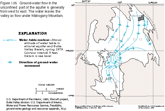
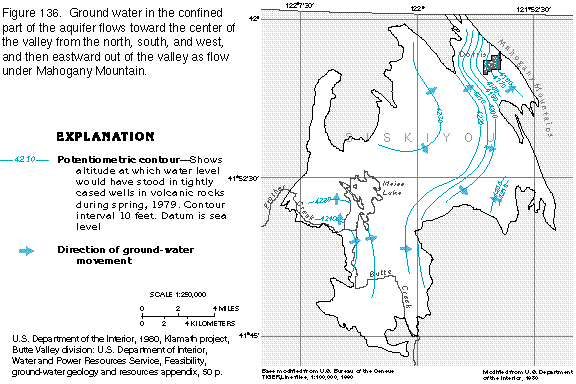
Flow in the unconfined part of the aquifer is generally from west to east (fig. 135), whereas flow in the volcanic rocks that contain water under confined conditions is toward the center of the valley from the north, south, and west and then toward the east (fig. 136). The potentiometric surfaces shown in figures 135 and 136 indicate that the hydraulic head of the unconfined part of the aquifer is higher than that of the confined part at Mahogany Mountain, which is the eastern boundary of the valley. Because this is not a major recharge area, the downward hydraulic gradient and west-to-east flow in the valley suggest that ground water leaves the valley as flow through the volcanic rocks beneath Mahogany Mountain and flows toward Klamath Lake and the Klamath River in the adjacent valley to the east.
Well yields
Well yields in Butte Valley are highly variable because of the
permeability differences in the rocks and deposits. Yields vary
greatly in the volcanic rocks and the Butte Valley Basalt because
permeability depends on the thickness of the flow units and the
degree of fracturing within the flows. Wells that penetrate such
rocks in areas where flows are thin and contacts between flows
are numerous generally have large yields. Yields of wells completed
in the lake deposits likewise vary with location. The predominance
of fine-grained lake sediments in the northern, northwestern,
and central parts of the valley preclude large yields. Conversely,
numerous wells are completed in large sand and gravel beds in
the lake deposits on the eastern and southern sides of the valley.
Yields of wells completed in the lake deposits and pyroclastic rocks range from 1,500 to 4,000 gallons per minute. Specific capacities of individual wells range from 16 to 97 gallons per minute per foot of drawdown. Wells completed in the Butte Valley Basalt yield from 1,000 to more than 4,000 gallons per minute. Yields from wells completed in the volcanic rocks are highly variable and range from 700 to 5,000 gallons per minute.
Fresh Ground-Water Withdrawals
Estimates of ground-water withdrawals in Butte Valley during 1979
range from 62,000 to 72,000 acre-feet per year. Surface-water
use accounted for another 10,000 to 20,000 acre-feet of the approximate
total of 82,000 acre-feet of water used. Agricultural use far
exceeded urban use, which was only about 700 acre-feet. According
to a 1976 study, gross water demand for agriculture will eventually
reach 162,000 acre-feet annually in Butte Valley.
In 1980, 40,000 acre-feet per year of ground water was estimated to have left the valley as subsurface outflow, most of which cannot be recovered. Ground-water withdrawals during that same year were conservatively estimated to be 62,000 acre-feet per year. Thus, the maximum amount of ground water available in the valley for annual use is approximately 102,000 acre-feet. Most of the land available for future development is in the northern end of the valley where surface soils and subsoils consist of fine-grained lake deposits that do not allow irrigation return flow to reach the aquifer. Therefore, unless surface water is imported to augment natural recharge, the amount of water available for agriculture appears to be much less than the projected demand.
Current (1995) usage is less than the amount of ground water available. Water levels might fluctuate as a result of annual precipitation and withdrawal cycles but are essentially unchanged in the long term. However, because of the limited storage capacity of the Butte Valley Basalt and the large volume of withdrawals from that formation, water-level decline is sufficient to cause some wells to go dry during the withdrawal season. Water levels recover, however, when withdrawals cease after the growing season. Deepening wells so that they penetrate the underlying sand and gravel of the lake deposits or the volcanic rocks could alleviate this seasonal situation.
Ground-Water Quality
The quality of ground water in Butte Valley is generally suitable
for most uses. Dissolved-solids concentrations in the water rarely
exceed 500 milligrams per liter. However, owners of a few wells
completed in the volcanic rocks report that the water has a sulfur
odor, and sodium concentrations exceed 50 milligrams per liter
in water from a few wells completed in these rocks. Shallow wells
completed in the lake deposits about 4 miles southwest of Dorris
produce highly mineralized water that exceeds 500 milligrams per
liter dissolved-solids concentrations probably because the water
that recharges the aquifer in that area becomes mineralized while
percolating through the overlying playa deposits.