INTRODUCTION
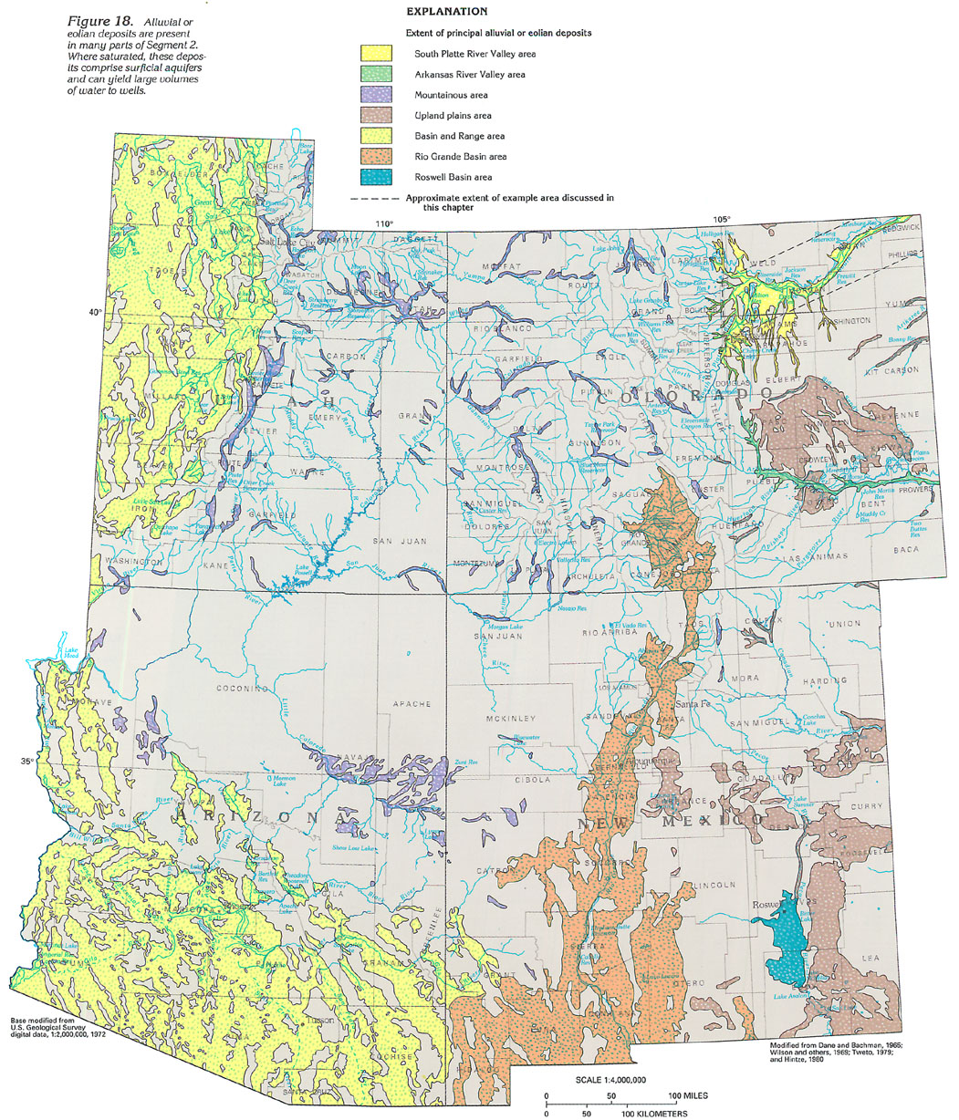
Surficial aquifers that are present in many parts of Segment 2 (fig. 18) generally contain the shallowest ground water in the Segment. These aquifers consist of Quaternary deposits of alluvial gravel, sand, silt, and clay or Quaternary deposits of eolian sand and silt. The alluvial and eolian deposits of the South Platte River Valley and the Arkansas River Valley are moderately thick and extensive and contain the two major surficial aquifers in Segment 2.
Surficial aquifers also are present in alluvial deposits of the Basin and Range, the Rio Grande Basin, and the Roswell Basin (fig. 18). However, these shallow aquifers are part of deeper or more extensive aquifers and are described with the deeper aquifers in subsequent sections of this Chapter.
In the more mountainous parts of Segment 2, much of the alluvium in the stream valleys is too thin, narrow, and discontinuous to be considered a major aquifer, even though some of the larger of the mountain alluvial deposits (fig. 18), such as those near the Sevier River in central Utah and in the Uinta Basin of northeastern Utah, contain locally important surficial aquifers. However, these aquifers commonly are thin and little utilized, and the extent of the aquifers within these materials is poorly known.
The surficial aquifer along the South Platte River in Colorado was selected as an example of a stream-valley aquifer in Segment 2 because it is extensively used and well studied. Although the information presented is specific to this aquifer, the hydrologic processes described are similar in other stream-valley aquifers in the Segment.
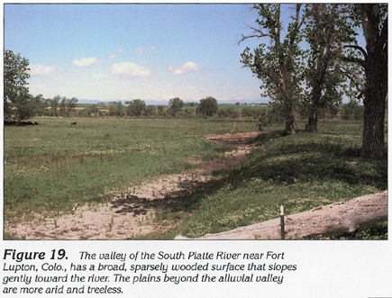
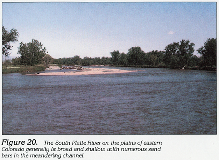
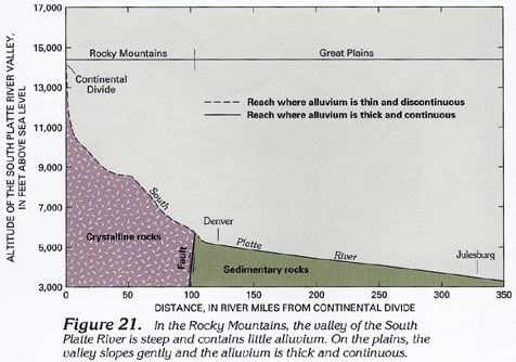
The stream valley of the South Platte River is eroded into the surface of the underlying bedrock formations. In the mountains and plains, the bedrock generally is much less permeable than the alluvium and forms a relatively impermeable lower boundary to the alluvial aquifer. The sedimentary rocks that underlie the alluvium of the South Platte River Valley on the plains generally consist of shale and sandstone of Cretaceous age that are easily eroded to form broad, gently sloping valleys (fig. 19) that contain meandering streams (fig. 20) and moderately thick alluvium. The headwaters of the South Platte River flow on crystalline rocks of the Rocky Mountains. In this area, stream gradients are steep, the valley narrow, and alluvium is thin and discontinuous (fig. 21).
The surficial aquifer South Platte River extends for about 200 miles in Segment 2. The aquifer ranges in thickness from about 20 to 200 feet and ranges in width from about 1 to 15 miles. Smaller deposits of alluvium or windblown sand extend up the valleys of numerous tributaries (fig. 18). Where saturated, these deposits form an aquifer that can yield moderate to large volumes of water to wells.
HYDROGEOLOGIC UNITS
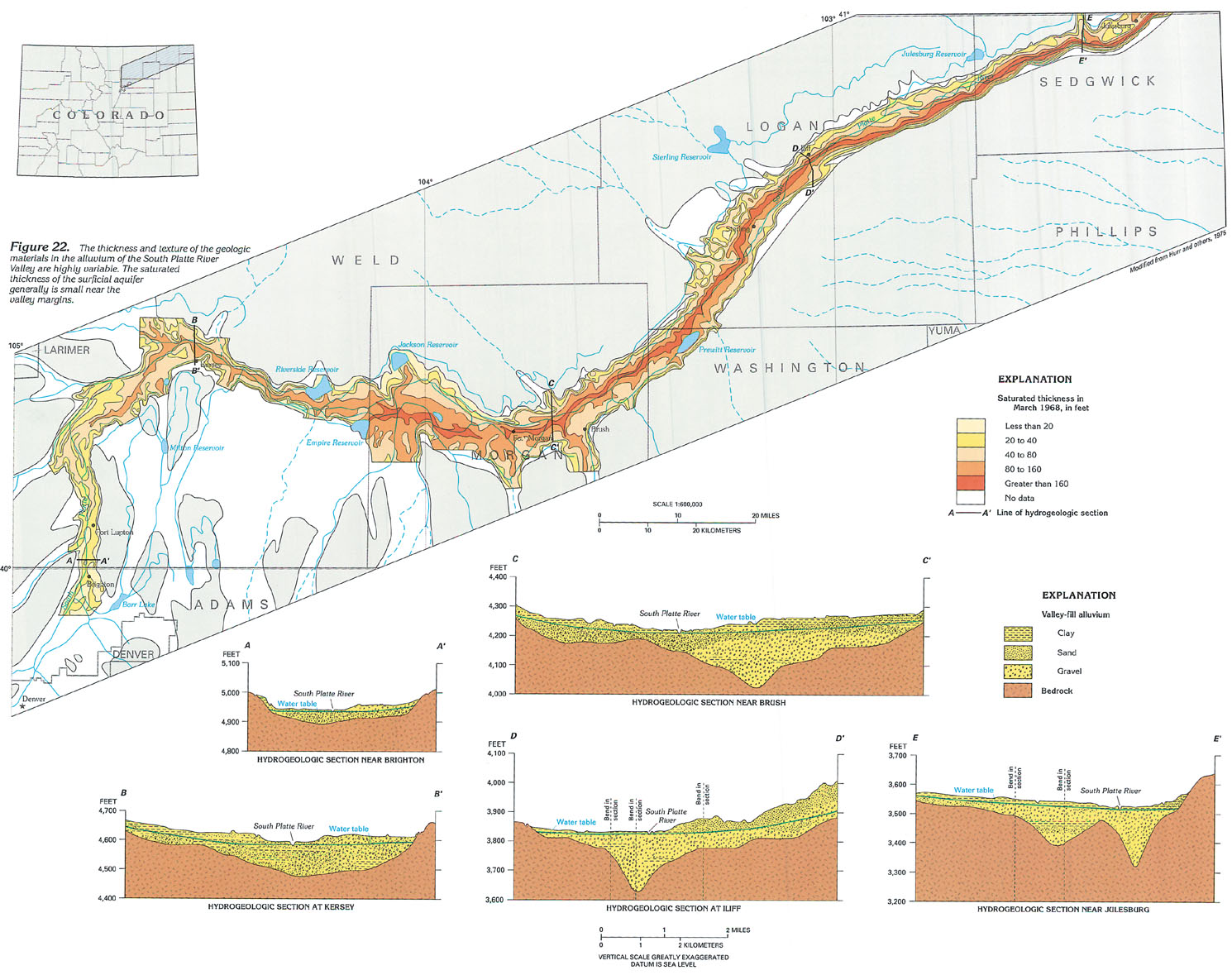
Alluvium in the valley of the South Platte River consists of poorly sorted mixtures of unconsolidated gravel, sand, silt, and clay or interlayer beds or relatively well-sorted sand, gravel, or silty clay. Beds may range in thickness from a few inches to 100 feet or more. Beds of gravel and cobbles occur at the base of the alluvium in the valley near Denver. Materials of finer grain size are more prevalent in the downstream parts of the valley in Colorado.
The thickness of the alluvium increases down the stream valley. In Denver, the alluvium has a maximum thickness of about 20 feet; 60 miles downstream (fig. 22, section B-B'), it has a maximum thickness of about 100 feet; about 100 miles farther downstream (fig. 22, section D-D'), the alluvium has a maximum thickness of about 200 feet. The thickness of the alluvium is more variable across than along the stream valley. In most areas, the alluvium thickens gradually from the margins of the valley to near the center (fig. 22, section B-B'). However, in some areas, the thickness of the alluvium is irregular because of the presence of two or more channels cut into the buried bedrock surface (fig. 22, section E-E'). Where tributary valleys enter the main valley, or where thick deposits of windblown sand overlie the alluvium, a thick part of the valley-fill material can extend beyond the valley margin (fig. 22, section D-D').
The water table in the alluvium forms the top of the surficial aquifer. The saturated thickness of the aquifer is the distance from the water table to the base of the alluvium. Almost the entire thickness of the alluvium is saturated near the South Platte River where the water table is near land surface. Near the margins of the valley, the saturated thickness of the aquifer is generally much smaller than the thickness of the alluvium.
RECHARGE AND DISCHARGE
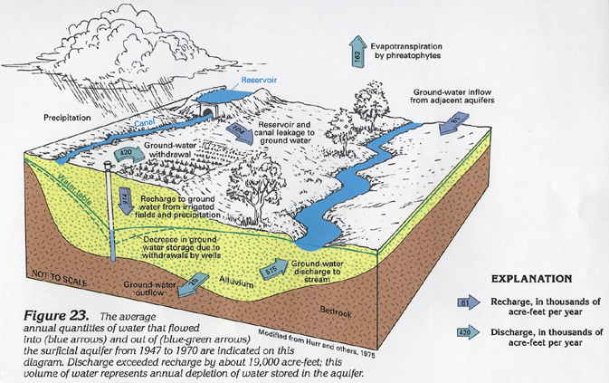
The volume of water than flows into (recharges) the surficial aquifer or flows out of (discharges from) the aquifer is affected by the presence of surface water in the area. The valley of the South Platte River is used extensively for irrigated agriculture. Water is supplied to the fields by diversion of surface flow in the South Platte River through an extensive network of irrigation canals and reservoirs. Surface water usually cannot supply all of the crop water requirements, and ground water is pumped to augment the supply. Some of the water in the irrigation canals and reservoirs percolates to the water table and recharges the aquifer. Between 1947 and 1970, the average rate of recharge from canals and reservoirs was about 104,000 acre-feet per year.
Part of the water applied to irrigated fields and part of the precipitation that falls in the valley also percolates downward and recharges the aquifer. Deep percolation of water applied to irrigated fields combined with precipitation supplied about to irrigated fields combined with precipitation supplied about 914,000 acre-feet per year of recharge to ground water (fig. 23). Recharge also occurs by inflow of water from adjacent alluvial aquifers, primarily in tributary valleys, or from underlying bedrock aquifers. Combined, these two sources supplied about 81,000 acre-feet per year of recharge. The total annual recharge to the surficial aquifer near the South Platte River was about 1,099,000 acre-feet.
Ground-water seepage to the channel of the South Platte River and withdrawal from wells are the most important forms of ground-water discharge. The South Platte River forms a natural drain for the surficial aquifer along almost all of the length of the river in eastern Colorado. During 1967-69, for example, the average rate of surface-water diversion from the river in Colorado was about 922,000 acre-feet per year, and the average flow at the Nebraska State line was about 340,000 acre-feet per year. However, only about 682,000 acre-feet per year of surface water flowed to the river from the headwaters and tributaries during this period. The difference in flow of about 580,000 acre-feet per year was supplied by ground-water discharge to the river.
In 1930, there were about 200 wells in the surficial aquifer near the South Platte River that were capable of yielding more than 100 gallons per minute. By 1970, the number of such wells had increased to slightly more than 3,200; the number of wells has remained relatively constant since 1970. The average yield of these wells was about 920 gallons per minute in 1970, but some well yields were as large as 3,200 gallons per minute. Most of these wells supply water for crop irrigation, but a few are used for the municipal supply of several communities in the valley. Numerous small-capacity wells supply water for domestic, stock, and other uses. Ground-water withdrawal for irrigation was about 388,000 acre-feet per year during 1951-60 and about 556,000 acre-feet per year during 1961-70.
During the period from 1947-70, discharge from the surficial aquifer by ground-water seepage to the South Platte River averaged about 515,000 acre-feet per year. Withdrawal by wells averaged about 420,000 acre-feet per year, evapotranspiration from vegetation growing in areas of shallow water table (phreatophytes) averaged about 163,000 acre-feet per year, and outflow to Nebraska of ground water in the alluvium averaged about 20,000 acre-feet per year (fig. 23). The total discharge from the surficial aquifer averaged about 1,118,000 acre-feet per year. Discharge exceeded recharge by about 19,000 acre-feet per year; as a result, there was a decline in the volume of ground water in storage in the surficial aquifer. For comparison, the total volume of ground water in storage in the aquifer was about 8,300,000 acre-feet.
WATER-LEVEL CONDITIONS
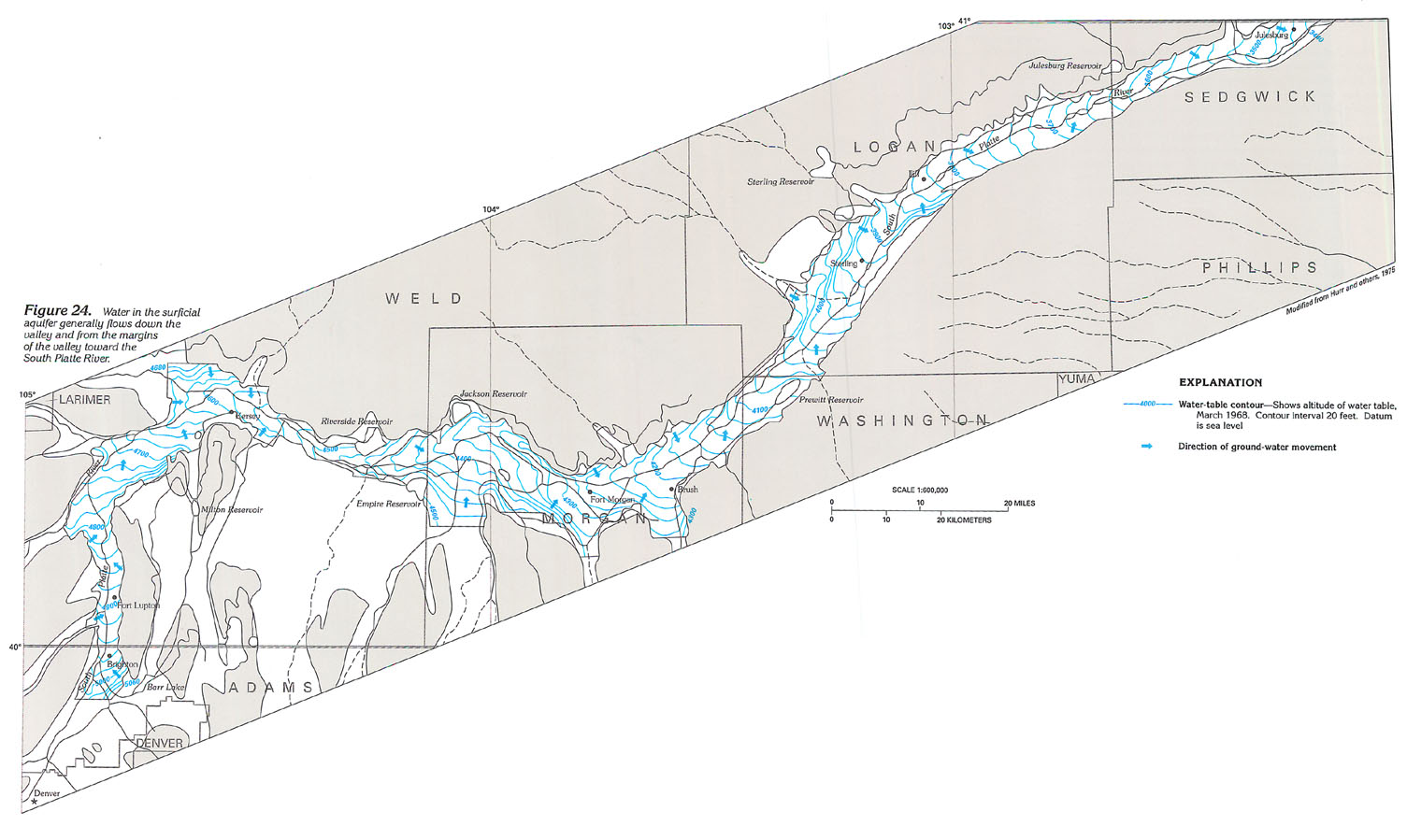
Ground water flows from areas of recharge, where the water-table altitude is higher, toward areas of discharge, where the water-table is lower. Recharge areas associated with canals, reservoirs, and irrigated fields generally are located along the valley on either side of the South Platte River. As a result, the altitude of the water table near the margin of the valley generally is higher than in the central part of the valley (fig. 22, sections A-A' through E-E'). Because ground-water discharges readily to the river, the altitude of the river determines the altitude of the water table along the valley. For example, the altitude of the river and the water table both range from about 5,000 feet near Denver to about 3,500 feet at Julesburg, which is 200 miles downstream (fig. 24).
The direction of ground-water movement generally is down the valley and toward the South Platte River, as indicated by the arrows on figure 24. This movement and the practice of diverting surface water creates a cycle of water reuse. Ground water discharges to the river; part of the river's flow is diverted into irrigation canals, reservoirs, and irrigated fields where some of the water percolates back into the aquifer. Some of this recharge ultimately flows back into the river. As a result, some water that flows into this stream-aquifer system near Denver may be used and reused many times before it flows out of Colorado. Only in the spring when irrigation demands are small and streamflow is large as a result of runoff from the mountain snowpack can large volumes of surface water flow directly downstream and bypass the ground-water system.
Ground-water withdrawal lowers the water table and either decreases ground-water flow to the river or causes water to flow from the river into the aquifer near the site of withdrawal. Thus, ground-water withdrawal has an effect on streamflow similar to that of surface-water diversion. Both decrease streamflow, but the slow rate of ground-water movement delays the effect of withdrawal of streamflow, whereas the effect of surface-water diversion is immediate.
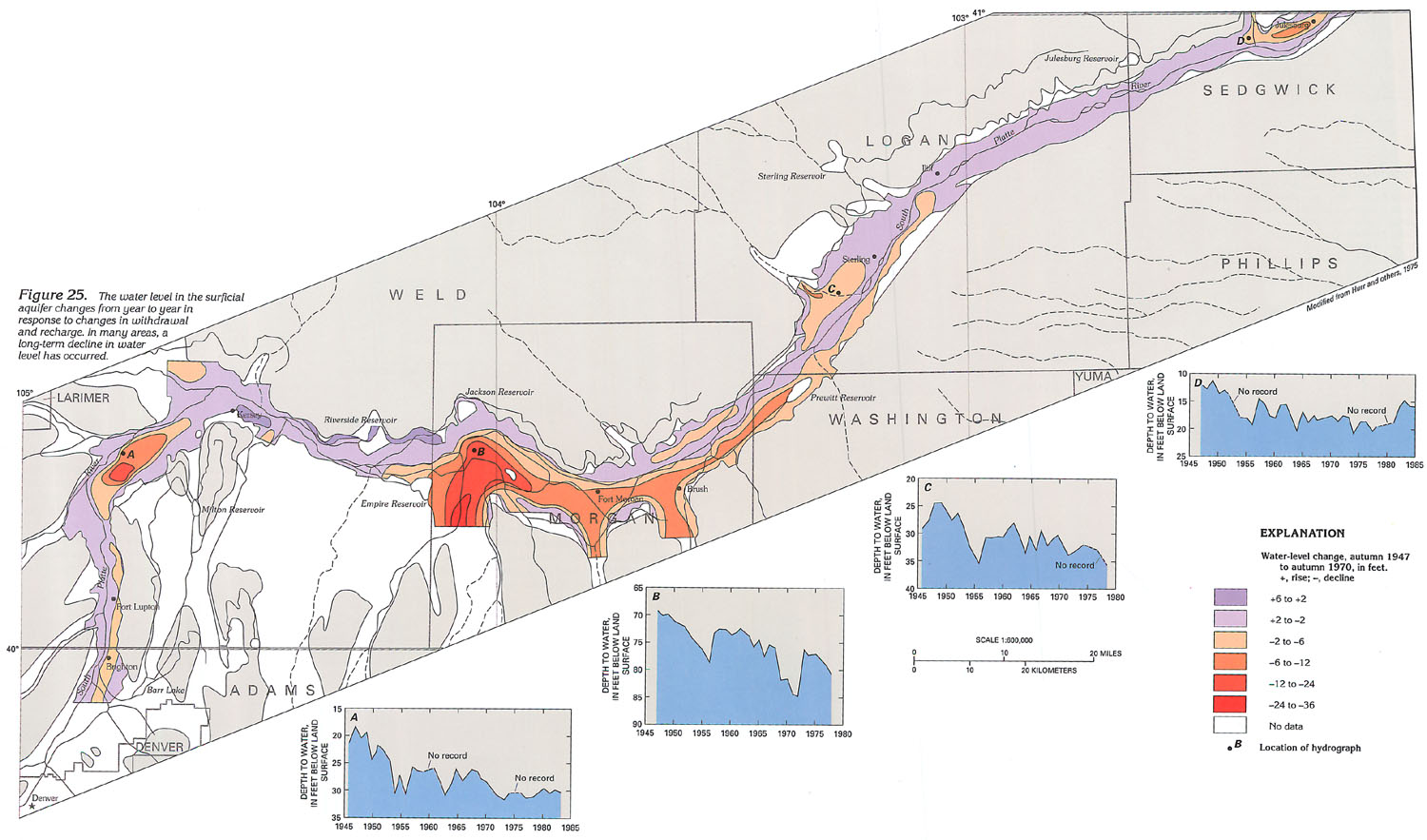
Between 1947 and 1970, water levels declined as much as 35 feet in parts of the surficial aquifer (fig. 25). The magnitude of annual decline varied from year to year, primarily in response to changes in the annual rate of ground-water withdrawal. Other factors that affect the decline include availability of surface water, precipitation during the growing season, and crop size and water requirements.
AQUIFER CHARACTERISTICS
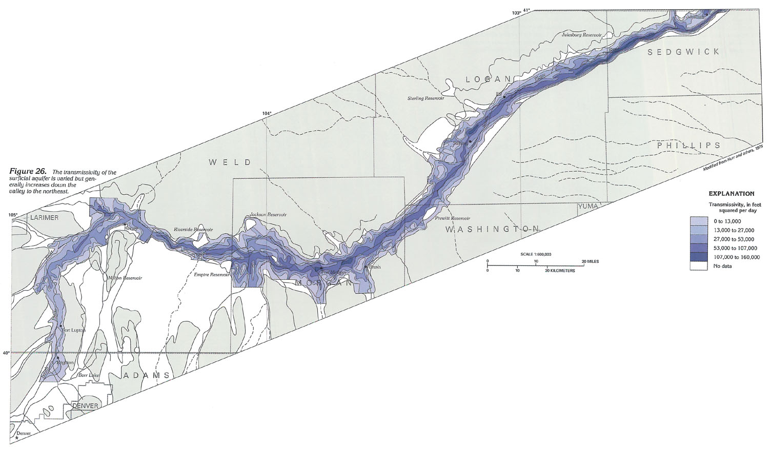
The ability of the surficial aquifer to transmit water is determined by the thickness of the aquifer and by the uniformity and coarseness of the sand and gravel in the aquifer. This ability to transmit water is called transmissivity. An aquifer of large transmissivity easily transmits water and can yield larger volumes of water to wells than an aquifer of small transmissivity.
The transmissivity of the surficial aquifer along the South Platte River ranges from less than 1,000 feet squared per day along the margins of the aquifer where the aquifer is thin to more than 100,000 feet squared per day in a few areas near the central part of the lower valley where the aquifer is thick (fig. 26). The transmissivity of the aquifer also increases down the valley, primarily because of the increased thickness of alluvium downstream.
GROUND-WATER QUALITY
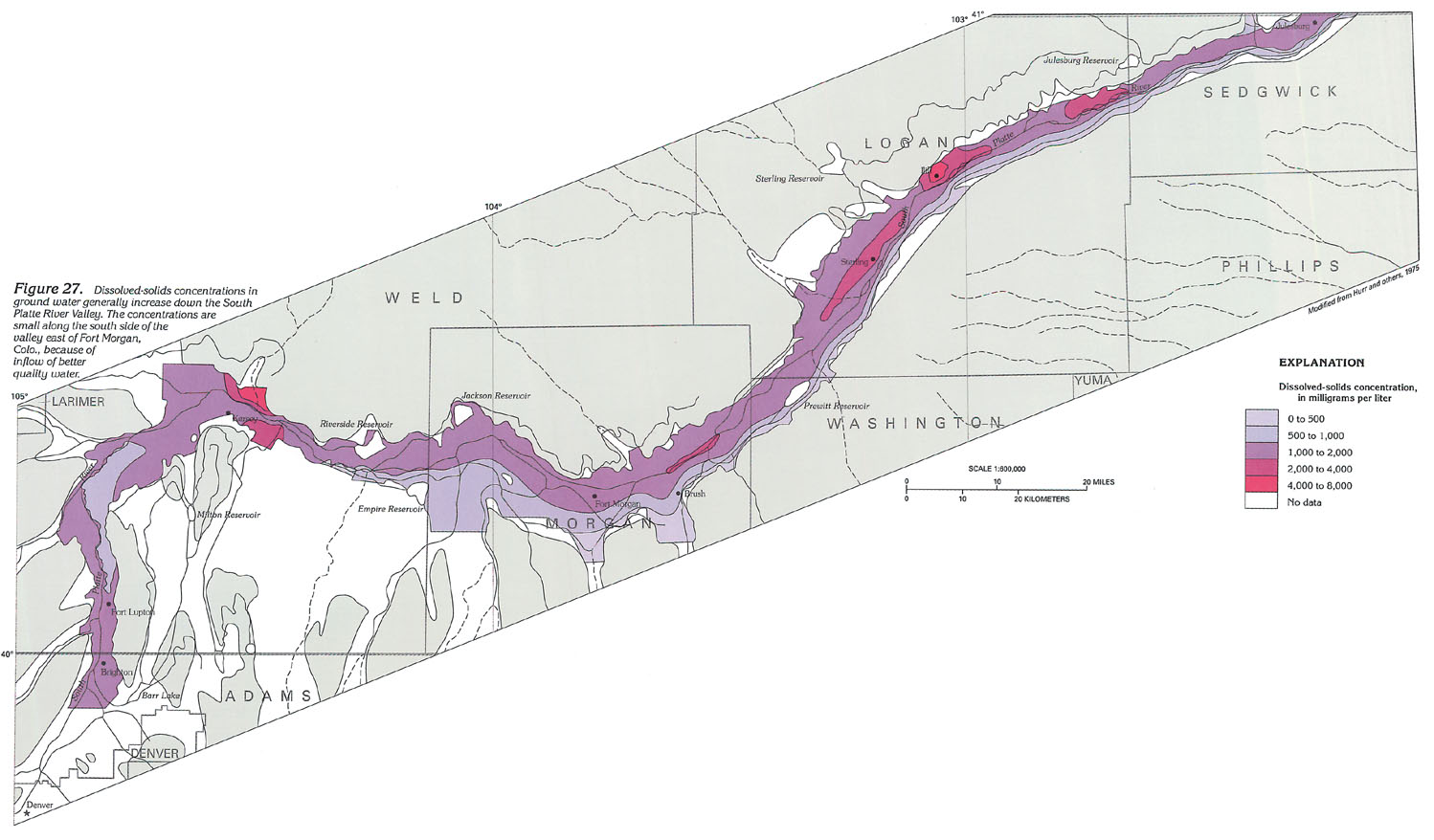
Dissolved-solids concentrations in ground water generally increase with distance downstream from the headwaters of the South Platte River. Surface water that flows from the headwaters into the South Platte River contains about 300 to 800 milligrams per liter of dissolved solids. Most of this water is ultimately diverted and applied to fields. Part of the applied water is consumed by evaporation or by transpiration of the crop, and this increases the dissolved-solids concentration in the remaining water. Fertilizer and other agricultural chemicals also are dissolved in the water and carried into the aquifer. As the water flows through the aquifer, additional minerals are dissolved from alluvial material. As a result, the ground water that returns to the river contains larger concentration of dissolved solids than the water was diverted from the river. Downstream, water again is diverted from the river and applied to another field. This recycling of water causes an increase in dissolved-solids concentration in the ground water down the valley. In some areas, dilution occurs when recharge from precipitation and inflow from tributary aquifers and upland areas underlain by thin alluvium or sand dunes decreases the dissolved-solids concentrations in water in the surficial aquifer (fig. 27). These processes causes the decreases in dissolved-solids concentration evident along the south side of the valley downstream from Fort Morgan, Colo.
Dissolved-solids concentrations of ground water range from about 1,000 milligrams per liter near Denver to as much as 4,000 milligrams per liter at Sterling. Downvalley from near Sterling, the concentration decreases because of dilution by ground-water inflow. Near Julesburg, the dissolved-solids concentration of the ground water is about 1,500 milligrams per liter. The dissolved-solids concentration of ground water also varies across the width of the valley and is larger near the river than near the margin of the valley. Surface water that flows into Nebraska has an average dissolved-solids concentration of about 1,300 milligrams per liter.
Water in the surficial aquifer generally contains large concentrations of dissolved calcium, bicarbonate, and sulfate, and is classified as either a calcium bicarbonate- or calcium sulfate-type water. Calcium bicarbonate water is more prevalent in the upstream part of the valley; calcium sulfate water is more prevalent in the downstream part. Water is classified as very hard if it contains more than 200 milligrams per liter hardness, measured as calcium carbonate. Water from more than 90 percent of a sampling of 89 wells in the downvalley part of the aquifer had hardness in excess of 200 milligrams per liter, and 50 percent had hardness in excess of 600 milligrams per liter. Ground water in some areas also contains large concentrations of dissolved iron, nitrate, or chloride. Although many local residents and communities have long used the aquifer as a source of drinking water, the water is not well suited for this use because of its taste, large dissolved-solids concentrations, hardness, or localized large concentrations of iron, nitrate, or sulfate. In some areas, using ground water for irrigation may require careful management of the water to prevent buildup of crop-damaging salts in the soil. However, in most areas, the surficial aquifer yields water that is of suitable quality for irrigation, and the dissolved minerals that make the water objectionable for public or domestic uses are not a serious problem for irrigation use.
FRESH GROUND-WATER WITHDRAWALS
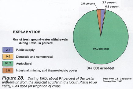
About 94 percent of the water withdrawn from the surficial aquifer in the South Platte River Valley during 1985 was used for irrigation. Public supply was the second largest category of water use but represented only about 3 percent of the total (fig. 28). The sum of the remaining categories of water use represented slightly more than 3 percent of the total ground-water withdrawal of 847,000 acre-feet.
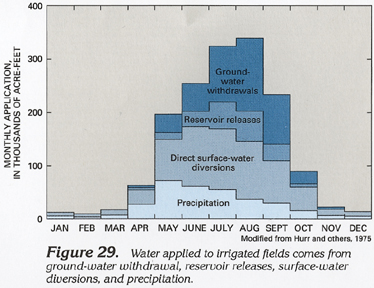
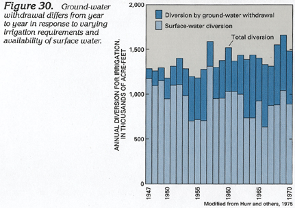
Water used for irrigation generally is applied to fields during the May-to-September growing season (fig. 29). Precipitation and surface water diverted directly from the South Platte River or diverted through reservoirs supply most of the applied water. Ground water supplies a larger part of the total applied water in July, August, and September as streamflow decreases following the peak period of snowmelt runoff in May and June. During dry years, when streamflow is small, larger quantities of ground water are withdrawn to meet crop water requirements (fig. 30).