INTRODUCTION
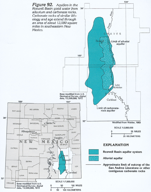
Large volumes of ground water are withdrawn from an alluvial aquifer and an underlying carbonate-rock aquifer in the Roswell Basin of southeastern New Mexico. These two aquifers form the Roswell Basin aquifer system (fig. 92). The aquifer system underlies part of the Pecos River and extends through an area of about 2,200 square miles from north of Roswell to northwest of Carlsbad, N. Mex. Although the alluvium covers an area of approximately 1,200 square miles, it is an important aquifer only in about 740 square miles, primarily along the western side of the Pecos River. Ground water in Permian carbonate rocks is present in openings formed by dissolution of part of the limestone, dolomite, and gypsum that are prevalent in the rock. Carbonate rocks underlie an area of about 12,000 square miles between Vaughn, New Mexico, and the New Mexico-Texas State line. The most permeable and extensively utilized aquifer in the carbonate rocks is in the Roswell Basin. This aquifer and the hydraulically connected aquifer in the alluvium have been studied extensively because of the importance of this source of ground water. Other aquifers in the 12,000-square-mile area of carbonate rocks are discontinuous and yield large volumes of water only in local areas or yield slightly saline water due to dissolution of saline minerals that are prevalent in some areas. Although the following description pertains to the geohydrology of the Roswell Basin, the geohydrologic processes described likely are characteristic of the numerous other small carbonate-rock aquifers in the 12,000-square-mile area.
Ground water that flows through joints, fractures, or faults in soluble rocks composed of carbonate (limestone or dolomite) or evaporite (gypsum or halite) minerals can dissolve the surrounding rock and enlarge the openings. Over geologic time, a vast network of interconnected openings can develop in the rock, and large volumes of ground water can flow through the openings. Large caverns also can form; Carlsbad Caverns, which is about 20 miles southwest of Carlsbad, N. Mex., is an example of large solution caverns in a limestone formation. When solution-altered rock becomes sufficiently porous, it may lack the strength to support the weight of overlying materials, and a broad gradual collapse of the rock can occur. The collapse reduces the thickness of the formation and creates additional fractures that are subject to further dissolution. A local, and sometimes rapid, collapse of the rock can produce sinkholes and create a craterlike appearance known as karst topography on the land surface.
Unfractured and unaltered carbonate rocks and evaporite minerals generally have low permeability and do not readily yield water to wells. However, dissolution of these rocks can create extremely large or numerous solution openings; altered rocks of this type can be among the most permeable water-yielding formations. A more comprehensive discussion of the hydrology of carbonate rocks is contained in Chapters G and K of this Atlas.
HYDROGEOLOGIC UNITS
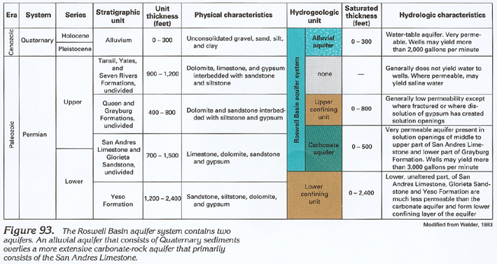
The Yeso Formation is the oldest geologic unit that has hydrologic significance in the Roswell Basin (fig. 93). The formation consists of sandstone and interbedded siltstone, dolomite, and gypsum and is 1,200 to 1,400 feet thick in the Roswell Basin. Near the land surface, dissolution of dolomite and gypsum locally can produce some permeability in the Yeso, but at depth, dissolution is minimal, and sandstone likely is the principal permeable unit. The permeability of the formation at depth is much smaller than that of the overlying carbonate rocks, and the Yeso functions as a lower, leaky, confining unit for the carbonate-rock aquifer.
Ground water in the carbonate-rock aquifer in the Roswell Basin primarily is present in solution-altered zones in the San Andres Limestone and the overlying Queen and Grayburg Formations (fig. 94). These formations dip to the southeast and thin to the northwest. Strata of the Tansil, Yates, and Seven Rivers Formations overlie the Queen Formation on the eastern margin of the Roswell Basin. The San Andres Limestone is at depths ranging from 300 to 1,300 feet along the eastern margin and crops out in a broad band along the western margin of the basin. Limestone and dolomite are the principal rocks in the San Andres, although a 100- to 200-foot-thick sandstone (Glorieta Sandstone) is near the base of the formation. The San Andres Limestone is 1,200 to 1,500 feet thick along the eastern margin of the basin but thins to 700 to 1,000 feet in the northwestern part of the basin where dissolution and collapse have decreased the thickness of the unit.
The Grayburg and Queen Formations overlie the San Andres Limestone. The Grayburg Formation predominantly consists of dolomite and gypsum with interbedded sandstone and shale. The Queen Formation consists of fine-grained sandstone and siltstone with interbedded gypsum. The two formations are 400 to 800 feet thick along the eastern margin of the basin and thin westward as the result of erosion and dissolution. In the southern one-half of the Roswell Basin, the lower part of the Grayburg Formation has been solution altered, and the carbonate-rock aquifer extends upward into this unit.
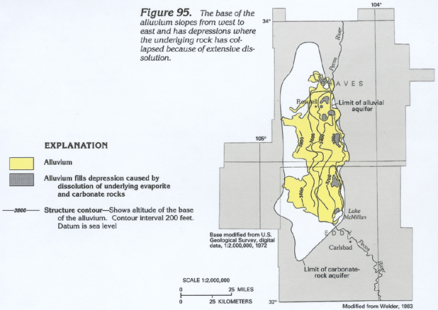
The San Andres Limestone and the Grayburg and Queen Formations were subject to extensive erosion prior to the deposition of the much younger alluvium in the Roswell Basin. Extensive dissolution of near-surface parts of these carbonate formations likely occurred during this period and may have continued after deposition of the alluvium. A map of the altitude of the base of the alluvium (fig. 95) reveals the presence of depressions in the buried surface of the bedrock that are similar to those in areas of karst topography.
The Seven Rivers, Yates, and Tansil Formations overlie the Queen Formation and crop out at higher altitude than the alluvium in the northern part of the basin. In the central and southern parts of the basin, the three formations laterally abut the alluvium or underlie the eastern part of the alluvium. The three formations consist of dolomite, limestone, and gypsum, with interbedded sandstone and siltstone. In the northern part of the basin, dissolution of these formations has been minimal. In the extreme southeastern part of the basin, the three formations have undergone dissolution and contain a local carbonate-rock aquifer.
Quaternary alluvium that consists of unconsolidated gravel, sand, silt, and clay unconformably overlies Permian rocks in the Roswell Basin. Alluvium and associated terrace deposits form a 10- to 20-mile-wide band, primarily to the west of the Pecos River. The deposits extend from about 10 miles north of Roswell to about 10 miles north of Carlsbad (fig. 92). The alluvium generally is 150 to 300 feet thick near the Pecos River and thins to the west, but the thickness is irregular because of the collapse of solution openings in the underlying rocks.
The alluvium contains water under unconfined (water table) conditions in the eastern one-half of its areal extent; elsewhere, the alluvium is unsaturated. The alluvial aquifer is hydraulically connected to the underlying carbonate-rock aquifer by leakage through the upper confining unit of the carbonate-rock aquifer. The water table in the alluvial aquifer is at or near land surface along most of the Pecos River, and the alluvial aquifer is recharged by, or discharges to, the river.
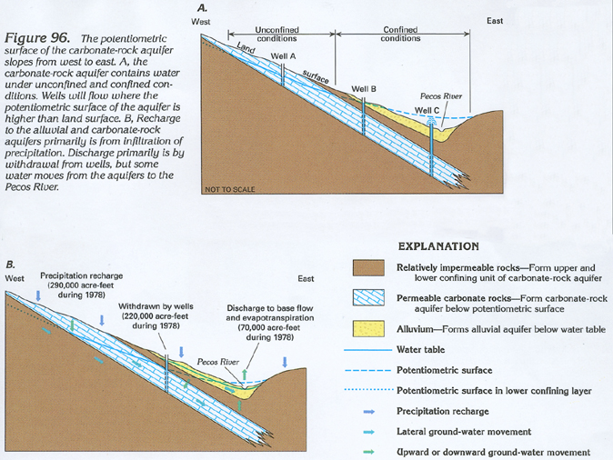
Solution-altered zones in the San Andres Limestone and the Grayburg Formation form the principal carbonate-rock aquifer in the Roswell Basin. The carbonate-rock aquifer is 200 to 500 feet thick in the eastern one-half of the basin and thins northward and westward. The lower boundary of the aquifer is formed by the unaltered lower part of the San Andres Limestone or the Glorieta Sandstone, or the underlying Yeso Formation, all of which are much less permeable than the aquifer. The upper part of the Grayburg and the Queen Formations generally are little altered and have low permeability. The zones of low permeability in these two formations form the upper confining unit of the carbonate-rock aquifer and separate it from the overlying alluvial aquifer. In the western part of the basin, water in the carbonate-rock aquifer generally is under unconfined conditions (fig. 96), and recharge readily percolates from the land surface to the water table. In the eastern part of the basin, water in the carbonate-rock aquifer is under confined conditions, and flowing wells (fig. 96A, well C) are present in some low-lying areas where the potentiometric surface is above land surface.
RECHARGE AND DISCHARGE
Aquifers in the Roswell Basin primarily are recharged from infiltration of precipitation in the outcrop areas of the San Andres Limestone and the alluvium (fig. 96B). These two units are exposed at the land surface throughout most of an approximately 8,400-square-mile drainage area to the west of the Pecos River. In much of this area, ground water moves eastward toward the Roswell Basin through thin permeable layers in the basal part of the San Andres Limestone or through sandstone beds in the Glorieta Sandstone or the Yeso Formation. Much of the water that recharges the aquifers in the western part of the drainage area probably moves laterally and upward into the western margin of the much more permeable carbonate-rock aquifer. The carbonate-rock aquifer receives additional recharge from direct infiltration of precipitation, from surface water in streams and ponds, and from water applied to irrigated fields. In local areas where the potentiometric surface in the alluvial aquifer is higher than that of the carbonate-rock aquifer, additional recharge can occur by downward leakage of water from the alluvial aquifer through the upper confining unit and into the carbonate-rock aquifer.
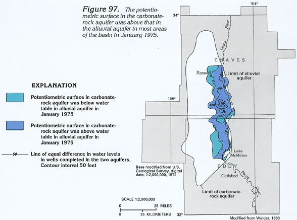
In most of the Roswell Basin, the potentiometric surface in the carbonate-rock aquifer was higher than that of the alluvial aquifer in 1975 (fig. 97). In low-lying areas near the Pecos River, the potentiometric surface in the carbonate-rock aquifer was above land surface, and flowing wells were present. The higher heads in the carbonate-rock aquifer caused the upward discharge of water from that aquifer either into the alluvial aquifer or to the land surface. Rocks beyond the eastern boundary of the carbonate-rock aquifer are relatively impermeable, and minimal discharge occurs across this boundary.
The alluvial aquifer receives recharge from infiltration of precipitation but also is readily recharged from water applied to the approximately 120,000 acres of irrigated fields that overlie the aquifer. The Pecos River flows on alluvium for most of its length in the Roswell Basin and is in hydraulic connection with the alluvial aquifer in most of this area. The alluvial aquifer generally discharges to the Pecos but can receive recharge from the river if ground-water withdrawals lower the water table near the river. The aquifer also discharges by evapotranspiration from areas where the water table is at shallow depth.
Ground-water withdrawals are the principal means of discharge from the aquifer system. Water-level declines caused by withdrawal have altered water-level relations between the alluvial and carbonate-rock aquifers and between the alluvial aquifer and the Pecos River. Before the development of the area's ground-water resources began in 1891, ground water moved from the western recharge areas through the carbonate-rock aquifer upward into the alluvial aquifer and then into the Pecos River. Water-level declines caused by withdrawal from the carbonate-rock aquifer locally have decreased, halted, or reversed the normal upward discharge from that aquifer. Withdrawals from the alluvial aquifer can have the same effect on the natural discharge to the Pecos River and also can induce upward discharge of water from the carbonate-rock aquifer.
The rate of natural recharge to the aquifers in the Roswell Basin has been estimated to range from 240,000 to 280,000 acre-feet per year on the basis of measurements made in 1926 and 1953. More recent measurements (1978) of base-flow gain in the Pecos River and measurements of ground-water withdrawal allow additional (although possibly no more accurate) estimates of the water budget of the basin. During 1978, the base flow in the Pecos River increased by about 20,000 acre-feet in the Roswell Basin reach of the river as the result of ground-water discharge to the river. Phreatophytes grow in part of a 64-square-mile area along the Pecos River and annually consume about 50,000 acre-feet of ground water. The combined ground-water discharge to phreatophytes and the Pecos River totaled about 70,000 acre-feet. During 1978, about 380,000 acre-feet of ground water was withdrawn; about 252,000 acre-feet was withdrawn from the carbonate-rock aquifer, and about 126,000 acre-feet was withdrawn from the alluvial aquifer through approximately 1,500 large-capacity irrigation, commercial, and industrial wells. This water primarily was used for irrigation, and about 160,000 acre-feet returned to the aquifer through infiltration. Effective withdrawal, which totaled 220,000 acre-feet, is the volume of water actually removed from the aquifers (fig. 96B). The total effective discharge from the aquifers in the Roswell Basin during 1978 was about 290,000 acre-feet. If the volume of ground-water in storage does not change, then this estimate of discharge also is an estimate of recharge to the aquifers. During 1978 and for several preceding years, the annual change in water levels in wells completed in the aquifers was small, which indicates that changes in ground-water storage were small. Thus, 290,000 acre-feet was the approximate volume of recharge to the aquifers during 1978. Because most of the recharge is supplied through infiltration of precipitation and runoff in the 8,400-square-mile drainage area to the west of the alluvial aquifer, the average rate of precipitation recharge was about 0.6 inch per year in 1978.
WATER-LEVEL CONDITIONS
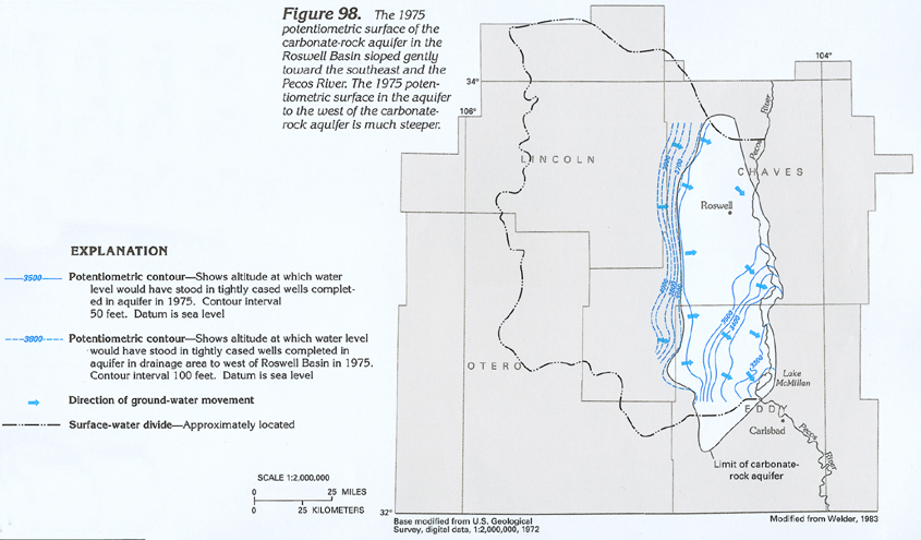
The 1975 potentiometric surface of the carbonate-rock aquifer in the Roswell Basin sloped gently to the southeast and ranged in altitude from about 3,550 to 3,250 feet above sea level (fig. 98). The potentiometric surface can be divided into three distinct zones on the basis of gradient. In the northern part of the basin, the potentiometric surface has a nearly flat southeasterly gradient of about 0.5 to 1.0 foot per mile. The potentiometric surface steepens markedly along a northeast-trending zone in the southern part of the basin. Gradients in this area generally are 10 to 50 feet per mile. This steepening of the potentiometric surface might be the result of a marked decrease in the effective transmissivity of the aquifer that is caused by the movement of water across bedding planes. This zone of steep gradient is located in the general area where the carbonate-rock aquifer extends across the stratigraphic contact between the San Andres Limestone on the northwest and the Grayburg Formation on the southeast (fig. 94). In the extreme southeastern part of the basin, the potentiometric surface is flatter; gradients are about 2 to 15 feet per mile.
The aquifer in carbonate rocks in the drainage area to the west of the Roswell Basin has a very steep potentiometric surface (fig. 98). Gradients in this area generally are 50 to 100 feet per mile in contrast to gradients of 1 foot per mile or less in the adjacent carbonate-rock aquifer in the Roswell Basin. This difference in gradient is the likely result of a difference in the transmissivity of the two aquifers; the carbonate-rock aquifer within the basin has much larger transmissivity.
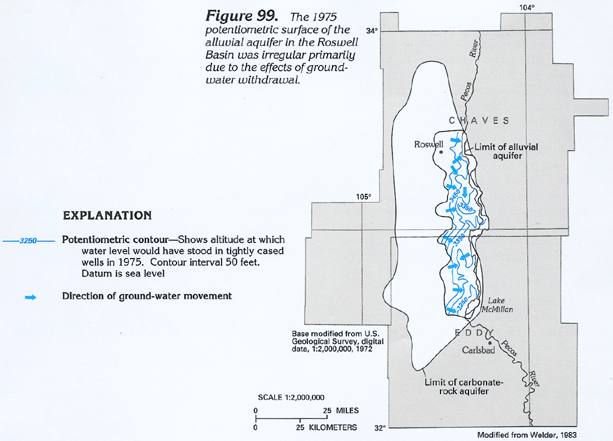
The 1975 potentiometric surface of the alluvial aquifer had a general slope from west to east toward the Pecos River (fig. 99), but the shape of the surface was irregular because of the effect of ground-water withdrawal. Large cones of depression near groups of pumping wells altered the shape of the potentiometric surface.
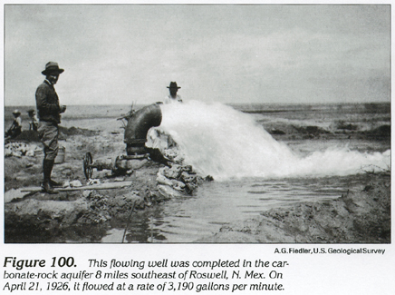
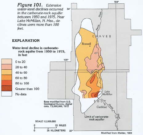
The Roswell Basin has a long history of ground-water use. The first wells were drilled in the basin in 1891, and by 1937, about 1,300 large-capacity irrigation, municipal, and industrial wells had been constructed. In 1926, when the first study of the hydrology of the basin was undertaken, water levels in the carbonate-rock aquifer were still as much as 100 feet above land surface in some areas near the Pecos River, and a few large-capacity wells flowed at rates of 3,000 to 5,000 gallons per minute (fig. 100). Between 1926 and 1950, the water level in the eastern part of the carbonate-rock aquifer declined 10 to 30 feet. From 1950 to 1975, water-level declines exceeded 40 feet in much of the aquifer and were more than 100 feet near Lake McMillan (fig. 101).
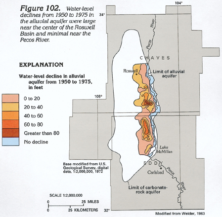
Water-level declines in the alluvial aquifer between 1950 and 1975 exceeded 40 feet in a few areas and exceeded 80 feet in one cone of depression near the center of the aquifer (fig. 102). Water-level declines along the eastern margin of the aquifer are moderated by the effects of recharge from the Pecos River; between 1950 and 1975 declines were minimal in this area. The areas of large water-level decline in the alluvial aquifer do not coincide with the areas of large water-level decline in the carbonate-rock aquifer. In 1950, the potentiometric surface in the carbonate-rock aquifer was higher than the potentiometric surface of the alluvial aquifer in most of the area of the alluvial aquifer. By 1975, ground-water withdrawal had produced large cones of depression in both aquifers, and the relation of the potentiometric surfaces was reversed in several areas (fig. 97).
Seasonal water-level declines caused by pumping during the March to September growing season have exceeded 120 feet in some observation wells completed in the carbonate-rock aquifer. Seasonal declines generally have not exceeded 30 feet in the alluvial aquifer. After the growing season, ground-water withdrawal decreases markedly, and water levels generally recover back to near the high level attained during the previous year. The large seasonal drawdown of water levels in the carbonate-rock aquifer causes seasonal increases in downward leakage of water from the alluvial aquifer and seasonal decreases in the volume of water discharged to the Pecos River.
AQUIFER CHARACTERISTICS
The transmissivity of an aquifer is a measure of the relative ease with which the aquifer transmits water. An aquifer of large transmissivity can sustain larger well yields, commonly contains a flatter potentiometric surface, and transmits larger volumes of water than an aquifer of small transmissivity.
Large differences in transmissivity are present in the aquifers of the Roswell Basin. In the northern part of the carbonate-rock aquifer where the potentiometric surface is relatively flat, transmissivity generally ranges from 30,000 to 50,000 feet squared per day, but values greater than 300,000 and less than 2,000 feet squared per day have been calculated from aquifer-test data for a few wells. These large differences in transmissivity likely are caused by the uneven distribution of solution openings in the aquifer. The transmissivity of the zone of steep potentiometric gradient in the southern part of the carbonate-rock aquifer is poorly documented but probably is small. In the southeastern part of the carbonate-rock aquifer, transmissivity ranges from about 8,000 to 20,000 feet squared per day. These values are smaller than those in the northern part of the aquifer, and the potentiometric gradients in this southeastern area are steeper than those in the northern part of the aquifer.
The transmissivity of the alluvial aquifer is more nearly uniform and generally is smaller than that of the carbonate-rock aquifer. Transmissivity of the alluvial aquifer averages about 13,000 feet squared per day and ranges from about 5,000 to 15,000 feet squared per day.
GROUND-WATER QUALITY
Ground water in the western part of the carbonate aquifer in the Roswell Basin generally contains a preponderance of dissolved calcium, magnesium, and sulfate and is classified as either a calcium sulfate or a calcium magnesium sulfate type water. Calcium concentrations generally range from 100 to 500 milligrams per liter, magnesium concentrations generally range from 50 to 130 milligrams per liter, and sulfate concentrations generally range from 300 to 1,400 milligrams per liter. The water is of similar chemical composition to that in other carbonate-rock aquifers where active dissolution of limestone, dolomite, and gypsum is occurring. The water is classified as very hard. Dissolved-solids concentrations generally range from 700 to 2,600 milligrams per liter.
Along the northeastern margin of the carbonate-rock aquifer, dissolved sodium and chloride concentrations in the water can be large; consequently, the water is classified as a sodium chloride type. Sodium concentrations in this area generally range from 1,500 to 3,000 milligrams per liter, and chloride concentrations range from 2,000 to 5,000 milligrams per liter (fig. 103). The water in this area is classified as very hard. Dissolved-solids concentrations range from 7,000 to 12,000 milligrams per liter.
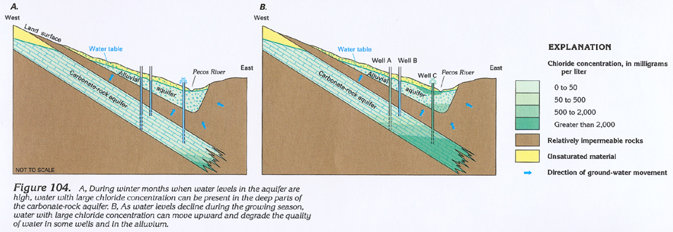
Water of large sodium chloride (salt) content is of particular concern in the Roswell Basin because most water is used for irrigation, and many crops can be damaged by excessive salt in the water and soil. The source of the large chloride concentrations in the carbonate-rock aquifer is uncertain but might be brine that moved across the relatively impermeable eastern boundary of the aquifer. Seasonal water-level declines in the carbonate-rock aquifer might temporarily reverse the direction of ground-water movement across the eastern boundary and enable brines in the deeper parts of the San Andres Limestone to move westward into the carbonate-rock aquifer. Chloride concentrations in water in the eastern part of the aquifer generally are larger near the end of the pumping season when water-level declines are large; concentrations decrease in the winter and early spring when water levels have returned to nonpumping levels. Large chloride concentrations in water samples from the bottom of some wells indicate that these concentrations are larger at greater depth in water in the eastern part of the carbonate-rock aquifer (fig. 104).
When water with large chloride concentration is deep in the carbonate-rock aquifer (fig. 104A), it has little effect on the water quality in shallow parts of the aquifer, and water pumped from wells is of relatively uniform quality. However, if the water with large chloride concentration is drawn farther into the aquifer (fig. 104B), then wells close to the eastern boundary can be severely affected (well C), and more westerly wells might be unaffected or only moderately affected (wells A and B), depending on well location and depth. Water in the carbonate-rock aquifer to the east of Roswell has undergone a marked increase in chloride concentration. Between 1959 and 1978, chloride concentrations increased by 1,000 to 2,000 milligrams per liter in water from some wells in this area. Increases in 1959-78 chloride concentrations generally have been less than 100 milligrams per liter along the southern one-half of the eastern margin of the aquifer.
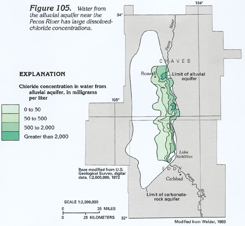
Water in the southern one-half of the alluvial aquifer generally is a calcium sulfate type. In the northern one-half of the aquifer, and at a few points along the southeastern margin of the aquifer, the water generally is a mixed calcium sodium sulfate chloride type. The water is very hard throughout the aquifer; dissolved-solids concentrations range from about 500 to 5,000 milligrams per liter. Chloride concentrations range from about 50 milligrams per liter along the western margin of the aquifer to about 2,000 milligrams per liter in a few areas along the eastern margin of the aquifer (fig. 105).
In the eastern part of the alluvial aquifer, chloride concentrations can be large in ground water near the upper or lower parts of the aquifer. Large concentrations in the upper part of the aquifer probably are caused by infiltration of water with large chloride concentration from local canals or from wells completed in more saline zones in the carbonate-rock aquifer (fig. 104B). Evapotranspiration by phreatophytes also concentrates dissolved minerals in the soil and shallow water table near the Pecos River. Water with large chloride concentration in the lower part of the alluvial aquifer likely is caused by upward movement of more saline water through the upper confining layer of the carbonate-rock aquifer. Both processes have caused water-quality degradation in the alluvial aquifer. Between about 1957 and 1978, chloride concentrations increased from 30 to 1,000 milligrams per liter in water from some wells.
FRESH GROUND-WATER WITHDRAWALS
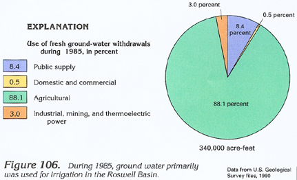
In 1978, about 95 percent of the 380,000 acre-feet of ground water withdrawn from the Roswell Basin was used for irrigation. In 1985, about 88 percent of the 340,000 acre-feet of ground water withdrawn from the basin was used for irrigation; about 8 percent of the withdrawal was used for public supply (fig. 106). Large-capacity wells completed in the carbonate-rock aquifer generally yield in excess of 3,000 gallons per minute. Smaller capacity wells commonly yield 500 to 1,500 gallons per minute. Large-capacity wells completed in the alluvial aquifer generally yield about 2,000 gallons per minute, and smaller capacity wells yield 300 to 700 gallons per minute.