MISSISSIPPI EMBAYMENT AQUIFER SYSTEM
INTRODUCTION
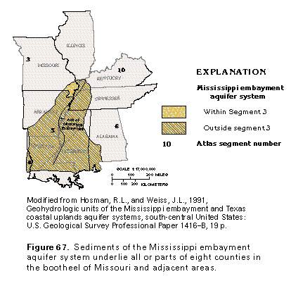
The Mississippi embayment aquifer system in Segment 3 is in southeastern Missouri (fig. 67) on the western side of the Mississippi Embayment section of the Coastal Plain Physiographic Province. The aquifers that comprise the aquifer system are unconsolidated to semiconsolidated sands that range in age from Eocene to Late Cretaceous. The Mississippi embayment aquifer system extends over large areas in Arkansas, Louisiana, and Mississippi and smaller areas in Alabama, Florida, Illinois, Kentucky, Missouri, and Tennessee (fig. 67). The aquifer system is areally extensive in Segment 5 of this Atlas and is discussed in greater detail in chapter F which describes that segment. Little freshwater is withdrawn from the Mississippi embayment aquifer system in Missouri because it is overlain in most places by the productive Mississippi River Valley alluvial aquifer.
HYDROGEOLOGIC UNITS
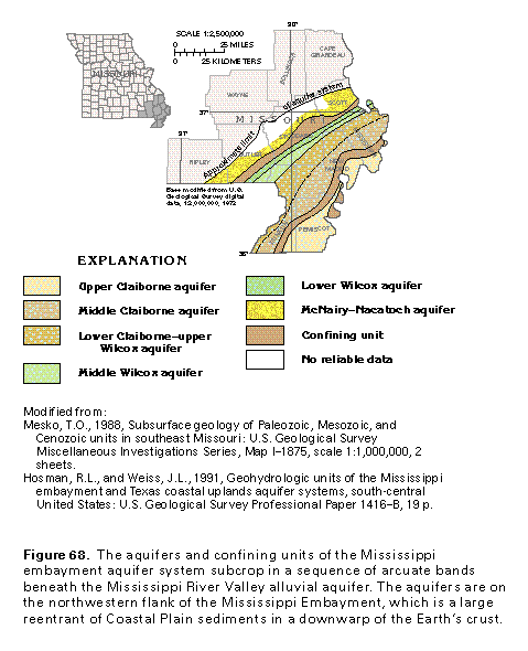
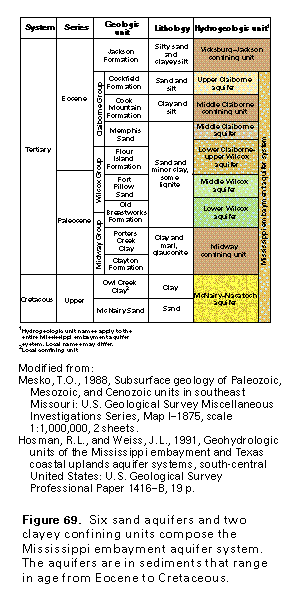
The six aquifers and two confining units that compose the Mississippi embayment aquifer system in Missouri subcrop as narrow bands (fig. 68) beneath the Mississippi River Valley alluvial aquifer. Five of the aquifers of the Mississippi embayment aquifer system are in Tertiary rocks (fig. 69). In descending order, these are the upper Claiborne aquifer, the middle Claiborne aquifer, the lower Claiborne-upper Wilcox aquifer, the middle Wilcox aquifer, and the lower Wilcox aquifer. The clayey middle Claiborne confining unit separates the upper Claiborne and middle Claiborne aquifers. The McNairy-Nacatoch aquifer, deepest aquifer in the system, is in sands of Cretaceous age and underlies thick clay of the Midway confining unit. Clayey silt of the Vicksburg-Jackson confining unit overlies the aquifer system locally in an area adjacent to Tennessee.
Although some of the aquifers in the Mississippi embay-ment aquifer system are not separated by regional confining units, they can be defined on the basis of changes in lithology and hydraulic head (water level) between aquifers. The vertical movement of water between the middle Claiborne through lower Wilcox aquifers is restricted somewhat by interbedded fine-grained sediments within the aquifers. In contrast, the middle Claiborne and Midway confining units more effectively retard the vertical movement of water between aquifers.
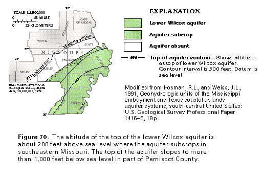
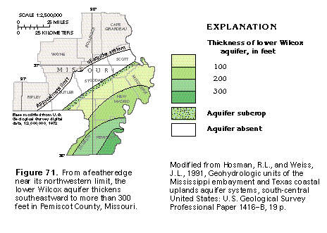
The extensive, massive water-yielding sands of the aquifer system slope and thicken in Missouri toward the axis of the Mississippi Embayment. The lower Wilcox aquifer has been chosen to illustrate the aquifer system because it extends over a wide area and has been penetrated by numerous wells. The top of the lower Wilcox aquifer is about 200 feet above sea level at its updip limit but slopes to more than 1,000 feet below sea level in southeastern Pemiscot County (fig. 70). On the opposite (Tennessee) side of the Embayment, the top of the aquifer is shallower. The aquifer, thus, has a troughlike shape, as do the aquifers that overlie and underlie it.
The lower Wilcox aquifer thickens from a featheredge at its northwestern limit to more than 300 feet in southeastern Pemiscot County (fig. 71). The troughlike shape of the aquifer is shown by the curvature of the lines of equal thickness near the Mississippi River. East of the river, the aquifer thins toward its outcrop area in Tennessee. Shallower and deeper aquifers in the Mississippi embayment aquifer system show the same thickening and thinning trends as those of the lower Wilcox aquifer.
GROUND-WATER FLOW
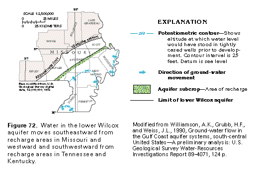
Because the Mississippi embayment aquifer system in Missouri is covered by the Mississippi River Valley alluvial aquifer in most places, the aquifer system is recharged mostly by downward leakage of water from the alluvial aquifer. Water enters the lower Wilcox aquifer in a band where sands of the aquifer are in hydraulic contact with those of the overlying Mississippi River Valley alluvial aquifer (fig. 72). The water then moves southeastward down the dip of the sand beds in the lower Wilcox aquifer. Water in the aquifer also moves westward and southwestward from aquifer outcrop areas in Tennessee and Kentucky. Because the lower Wilcox aquifer is deeply buried, this water moves under the Mississippi River without discharging to the river. Water discharges from the aquifer by upward leakage to shallower aquifers in Arkansas.
GROUND-WATER QUALITY
The chemical quality of freshwater in the aquifers of the Mississippi embayment aquifer system in Missouri is suitable for most uses. The water is fresh except locally in the McNairy-Nacatoch aquifer, which is the deepest aquifer of the system (fig. 73). Dissolved-solids concentrations in water from this aquifer locally exceed 2,000 milligrams per liter in New Madrid and Stoddard Counties and exceed 1,000 milligrams per liter in an area of about 450 square miles. Water in this area is a sodium chloride type and probably has entered the McNairy-Nacatoch aquifer by upward leakage from underlying Paleozoic rocks that locally contain saline water. Water in shallower aquifers of the Mississippi embayment aquifer system is fresher than that in the McNairy-Nacatoch aquifer.
Water in the aquifers of the Mississippi embayment aquifer system is a calcium magnesium bicarbonate type in aquifer recharge areas. As the water moves down the hydraulic gradient, it changes to a sodium bicarbonate type and locally changes to a sodium chloride type in deeply buried, down-gradient parts of the aquifers.
FRESH GROUND-WATER WITHDRAWALS
About 95 million gallons per day of freshwater was pump-ed from all the aquifers of the Mississippi embayment aquifer system in Missouri during 1990. Most of the water was withdrawn for agricultural, primarily irrigation, use. Because the overlying Mississippi River Valley alluvial aquifer is a thick, productive aquifer, larger amounts of water are withdrawn from it than from the deeper Mississippi embayment aquifer system.