RIO GRANDE AQUIFER SYSTEM
INTRODUCTION
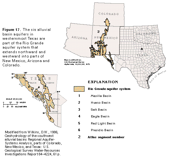
The Rio Grande aquifer system in westernmost Texas (fig. 17) corresponds to the eastern part of the Southwest alluvial basins aquifer system, which is a large system of aquifers in alluvial basins in the southwestern United States and Mexico. These aquifers were studied as part of the U.S. Geological Survey's Regional Aquifer-System Analysis program and are discussed in detail in Chapter C of this Atlas. A brief description and discussion of the aquifers as they exist in Texas are presented here.
The Rio Grande aquifer system in Texas is in Culberson, El Paso, Hudspeth, Jeff Davis, and Presidio Counties. The alluvial aquifers are found in six major basins: the Mesilla, the Hueco, the Salt, the Eagle, the Red Light, and the Presidio (fig. 17).
The Rio Grande aquifer system is in the Basin and Range Physiographic Province. Vertical movement along block faults has resulted in structurally high mountain ranges that trend south and southeast and are separated by structurally low parallel basins. The basin areas are filled with thick sequences of clastic sediments that have eroded from the adjacent highlands.
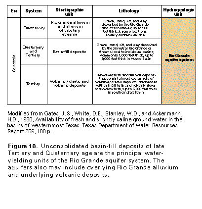
The basin deposits are of late Tertiary and Quaternary age and consist mostly of clay, silt, sand, and gravel (fig. 18). They are the principal source of water for the city of El Paso and the surrounding area, where precipitation is sparse (8-12 inches annually). Although a large volume of water is stored in the basin deposits, pumpage easily exceeds natural recharge and leads to long-term depletion of the stored water. Collectively, withdrawals from the Rio Grande aquifer system in Texas were about 126 million gallons per day during 1985.
MESILLA BASIN
The Mesilla Basin lies largely in New Mexico and Mexico. A small part of the basin is in western El Paso County between the Franklin Mountains on the east and the Rio Grande on the west. The western part of El Paso, a city which had a population of 464,000 in 1985, is in the southern end of the basin. The alluvial aquifer in the Mesilla Basin is a source of water for the municipal and industrial needs of El Paso.
The alluvial deposits of the Mesilla Basin are of late Tertiary and Quaternary age and are composed of gravel, sand, silt, and clay. The deposits are predominantly coarse grained around the margins of the basin and fine grained near the basin center. The Rio Grande alluvium is part of the Mesilla Basin alluvial aquifer; it overlies the older basin fill, from which it cannot be easily distinguished. The total thickness of the unconsolidated deposits in the Mesilla Basin is estimated to be at least 2,000 feet, and the thickness of the Rio Grande alluvium is 150 feet or less.
The chemical quality of the water in the shallower part of the aquifer is influenced by the quality of the water in the Rio Grande. The water in the shallower part of the aquifer is generally more mineralized than that in the deeper part. Concentrations of dissolved solids in the shallower ground water locally are as much as several thousand milligrams per liter, whereas water from the deeper part of the aquifer commonly has dissolved-solids concentrations that are less than 300 milligrams per liter. The depth of freshwater extends to as much as 1,400 feet below land surface. Water in the southern one-half of the basin deposits is more mineralized than elsewhere. This could be due, in part, to the narrow valley outlet at El Paso that restricts ground-water outflow and prevents flushing of water with greater dissolved-solids concentrations.
Wells completed in the Mesilla Basin alluvial aquifer yield as much as 3,000 gallons per minute. Transmissivity of the aquifer is several thousand feet squared per day. The aquifer receives recharge by infiltration of runoff around the basin margins, and from seepage from the Rio Grande, ephemeral streams, canals, and excess irrigation water. During 1980, about 21 million gallons per day was pumped from the Mesilla Basin alluvial aquifer, nearly all for municipal and industrial uses. Before development, water levels in wells completed in the deeper parts of the aquifer were at land surface or a few feet above land surface, and ground water moved upward from the deeper to the shallower zones. After development, water-level gradients were reversed, and water from the Rio Grande alluvium and shallower zones within the basin deposits now leaks downward. This vertical percolation from the shallower deposits has apparently replenished deeper permeable zones in the aquifer and has caused long-term water-level changes to stabilize.
Assuming a specific yield of 10 percent for the unconsolidated deposits in the Texas portion of the Mesilla Basin and the adjacent mesa to the east, about 820,000 acre-feet of freshwater is estimated to be in storage in the deposits. The volume of slightly saline water stored in the Rio Grande alluvium is estimated to be about 300,000 acre-feet. (One acre-foot is the volume of water that will cover 1 acre of land to a depth of 1 foot, or about 43,560 cubic feet of water.) Although these volumes of water may be recoverable in theory, the volume of water that can be recovered in practice may be substantially less.
HUECO BASIN
The Hueco Basin is situated in parts of New Mexico, Texas, and Mexico. In Texas, the northern part of the basin lies between the Franklin Mountains on the west and the Hueco Mountains on the east. The unconsolidated alluvial deposits in the Hueco Basin consist of gravel, sand, silt, and clay. The deposits locally are as much as 9,000 feet thick in a deep trough adjacent and parallel to the Franklin Mountains. The deposits that compose the Hueco Basin alluvial aquifer include the Rio Grande alluvium, which is probably not more than 200 feet thick.
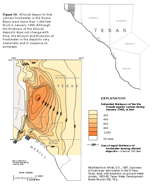
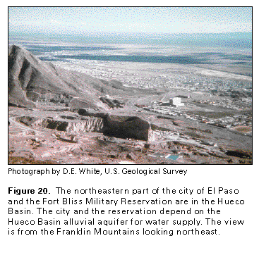
Between the Texas-New Mexico border on the north and the city of El Paso, the deposits of the Hueco Basin contain about 10 million acre-feet of freshwater in an approximately 7-mile-wide area adjacent and parallel to the Franklin Mountains. A map of the saturated thickness of the fresh-water-bearing alluvial deposits is shown in figure 19. In January 1980, these saturated deposits were more than 1,000 feet thick about midway between the Texas-New Mexico border and the Rio Grande at El Paso. An additional large amount of slightly saline water is available in deposits that underlie and adjoin the freshwater-bearing deposits to the east. Relatively rapid recharge to the aquifer by runoff from the Franklin Mountains into alluvial-fan deposits makes this a favorable area for ground-water development. During 1980, about 66 million gallons per day were withdrawn from the Hueco Basin alluvial aquifer in the El Paso-Fort Bliss Military Reservation area (fig. 20) for municipal, military, and industrial supplies.
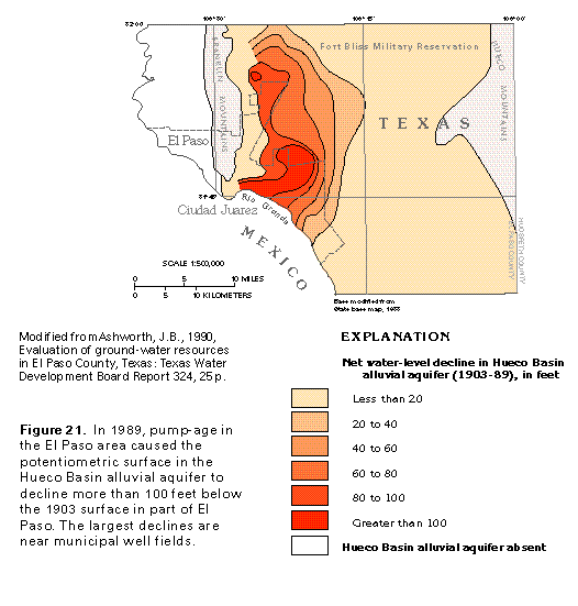
Under natural conditions, ground-water movement is toward the Rio Grande and in a down-valley direction. In developed areas, ground water moves toward centers of pumpage. Natural hydraulic gradients have been reversed in intensively pumped artesian areas, and water in the shallow alluvium moves downward across local confining units to replenish water that is pumped from deeper zones. Water-level declines have been large near municipal well fields. Net water levels declined more than 100 feet between 1903 and 1989 in the downtown areas of El Paso and Ciudad Juarez, Mexico, as shown in figure 21.
Where the alluvial deposits contain water under unconfined (water-table) conditions, the specific yield of the aquifer is estimated to be between 16 and 30 percent, and the transmissivity of the aquifer is estimated to range from 1,300 to 37,000 feet squared per day. Where local confining units create artesian conditions, the storage coefficient of the aquifer is about 0.0004 and the estimated transmissivity ranges from 6,700 to 16,000 feet squared per day. The storage coefficient and transmissivity for the deposits in the southeastern part of the Hueco Basin probably are substantially smaller. Wells completed in the aquifer yield as much as 3,000 gallons per minute.
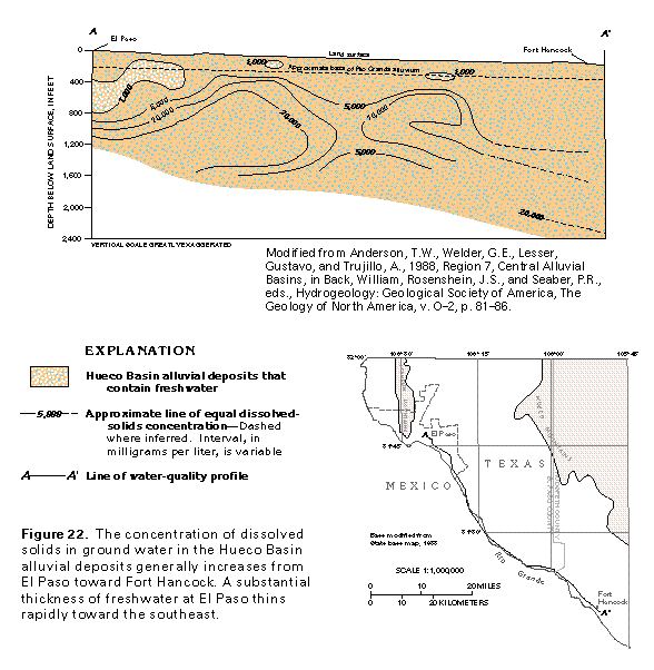
The basin fill in the southeastern part of the Hueco Basin is mostly fine grained and probably consists largely of playa deposits. Field data suggest that the thickness of the deposits in this area ranges from 1,000 to 3,000 feet. Sand and gravel are substantial only in the upper 200 to 400 feet, which includes the Rio Grande alluvium. The ground water generally becomes more mineralized with depth from the northern part of the basin toward the southeast. This is shown by a water-quality profile along a line that approximately follows the course of the Rio Grande from El Paso southeastward to about Fort Hancock in Hudspeth County (fig. 22). Water with less than 1,000 milligrams per liter dissolved solids is contained in deposits that are more than 400 feet thick in the vicinity of El Paso, but the freshwater diminishes rapidly toward the southeast. Although water with dissolved-solids concentrations of less than 1,000 milligrams per liter is desired for most public and industrial uses, waters with greater concentrations are acceptable for such uses as livestock watering and irrigation, and the southeastern part of the Hueco Basin alluvial aquifer is a valuable source of water for these purposes.
The city of El Paso's demands for fresh ground water are currently (1996) resulting in depletion of water in storage in parts of the Hueco Basin alluvial aquifer. Results of intensive pumping include declining water levels, decreased well yields, and deteriorating water quality. City planners anticipate that the demand for water in El Paso will soon exceed supply. To reduce demands and to increase future supplies, El Paso city officials are implementing conservation practices and artificial recharge programs.
SALT BASIN
The Salt Basin lies mostly in Texas, but a small part of the basin extends northward into New Mexico (fig. 17). From the New Mexico-Texas border into Presidio County, the width of the Salt Basin ranges from 5 to 20 miles, and the length is about 140 miles. The basin is bounded by various mountain ranges.
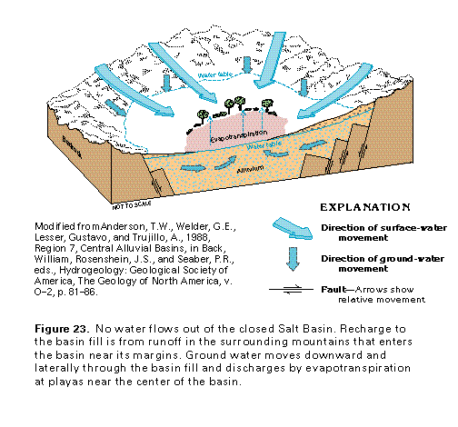
The deposits in the Salt Basin consist of clay, sand, gravel, caliche, and, in places, volcanic rocks and volcanic/clastic deposits (fig. 18). The Salt Basin is a closed basin; that is, no surface drainage leaves the basin. Recharge to the basin fill is mainly by runoff from the bordering mountains into alluvial fans. The water moves laterally and downward into the basin fill and then upward toward playa areas near the center of the basin where it is discharged mainly by evapotranspiration (fig. 23).
In the northern part of the basin, ground water moves upward toward playas that contain salt deposits. The alluvium in this part of the basin is relatively fine grained and mostly contains highly mineralized water. The water is slightly saline around the basin margin, moderately saline along the axis of the basin, and very saline to briny beneath the playa areas. Salt deposits that formed in the playas as a result of precipitation of minerals from ground water were commercially mined from 1863 until the early 1950's. Wells completed in the deposits yield as much as 1,200 gallons per minute. An average of about 4.5 million gallons per day was withdrawn from the Salt Basin alluvial aquifer from 1951 to 1972, primarily for irrigation in the northern part of the basin.
The deposits in the central part of the basin are coarse grained and are composed primarily of volcanic rocks and volcanic/clastic deposits. Fresh to slightly saline ground water is in this part of the basin, where the basin-fill deposits are as much as 2,400 feet thick. Estimates of specific yield for the deposits in the central part of the basin range from 5 to 10 percent. Large-capacity irrigation wells completed in the deposits yield from 400 to more than 1,000 gallons per minute. Water levels in the central part of the basin declined as much as 6.5 feet per year from 1951 to 1973.
Little ground-water development has occurred in the southern part of the basin, but sparse data indicate that well yields range from about 250 to 1,400 gallons per minute. The amount of freshwater in storage in the Salt Basin alluvial aquifer is estimated to be 6.5 million acre-feet; the estimated volume of slightly saline water in storage is 1.0 million acre-feet. About 75 percent of the total water is assumed to be recoverable. During 1960, about 32 million gallons per day was pumped from the Salt Basin alluvial aquifer.
EAGLE BASIN
The Eagle Basin is bounded by various mountain ranges. The southern part of the basin extends to the Rio Grande. The width of the basin ranges from 2 to 10 miles, and the length is about 60 miles. Most of the basin is in Hudspeth County, although the southern end extends into Culberson, Jeff Davis, and Presidio Counties.
The deposits in the basin consist of clay, silt, sand, gravel, volcanic rocks, and volcanic/clastic deposits. The deposits are more than 2,000 feet thick in the central part of the basin and in the southern part of the basin near the Rio Grande. Most wells completed in the basin-fill deposits are used for watering livestock and have small yields. Some irrigation wells reportedly yield between 1,000 and 1,500 gallons per minute. Specific-capacity data indicate a transmissivity of as much as 13,000 feet squared per day for the Eagle Basin alluvial aquifer in the Rio Grande Valley. Most of the recharge to the alluvial basin aquifer enters at the margins of the basin as runoff from the surrounding mountains. Ground water moves toward the axis of the basin and then southward to discharge to the Rio Grande.
RED LIGHT BASIN
The Red Light Basin is located in southeastern Hudspeth County. It is bounded on the north, west, and east by various mountains, and extends southward to the Rio Grande. The basin is filled with alluvium which consists of clay, silt, sand, and gravel, combined with volcanic rocks and volcanic/clastic deposits. The basin-fill deposits thicken toward the south and are more than 3,000 feet thick at the Rio Grande. The deposits contain at least some freshwater in most of the basin; however, substantial quantities of freshwater are available only in the central part. Only a few wells which have small yields and are used primarily for livestock watering have been completed in the deposits.
PRESIDIO BASIN
The Presidio Basin is in the western part of Presidio County and contains the southernmost aquifer of the Rio Grande aquifer system in Texas (fig. 17). The Rio Grande forms the western boundary for the basin; it is bounded on the east by mountains. The width of the basin ranges from 4 to 10 miles, and the length is about 70 miles. The basin contains great thicknesses of fine-grained alluvial deposits, volcanic rocks, and volcanic/clastic deposits. The basin-fill deposits are as much as 5,000 feet thick along the axis of the basin near the Rio Grande.
Ground water has been developed along the flood plain of the Rio Grande, where it is used mostly for irrigation; in other parts of the basin, ground water is pumped only for livestock watering and domestic use. Large-diameter irrigation wells in the flood plain of the Rio Grande at the southern end of the basin yield from 300 to 800 gallons per minute. Specif-ic-capacity data indicate a transmissivity of about 5,000 to 21,000 feet squared per day for the alluvial aquifer in the Rio Grande Valley. Recharge to the basin fill is mainly along the bordering mountains where small streams enter the basin. Ground water flows from the basin margins to the Rio Grande, where it is discharged either by evapotranspiration or by seepage to the river.
In the Rio Grande Valley in the central part of the basin, an estimated 5 million gallons per day of ground water was withdrawn for irrigation during 1960. An estimated 800,000 acre-feet of freshwater is in storage in the Presidio Basin alluvial aquifer; of this amount, an estimated 75 percent can be recovered.
FRESH GROUND-WATER WITHDRAWALS
An estimated 126 million gallons per day of freshwater was withdrawn from the Rio Grande aquifer system during 1985. About 77 million gallons per day was withdrawn for public supply, the principal use (fig. 24). About 30 million gallons per day was withdrawn for agricultural purposes, and about 10 million gallons per day was pumped for industrial, mining, and thermoelectric-power uses. About 9 million gallons per day was withdrawn for domestic and commercial uses.