INTRODUCTION
The four States-Alabama, Florida, Georgia, and South Carolina-that comprise Segment 6 of this Atlas are located adjacent to the Atlantic Ocean or the Gulf of Mexico, or both. These States are drained by numerous rivers and streams, the largest being the Tombigbee, Alabama, Chattahoochee, Suwannee, St. Johns, Altamaha, and Savannah Rivers. These large rivers and their tributaries supply water to cities such as Columbia, S.C., Atlanta, Ga., and Birmingham, Ala. However, the majority of the population, particularly in the Coastal Plain which comprises more than one-half of the four-State area, depends on ground water as a source of water supply. The aquifers that contain the water are mostly composed of consolidated to unconsolidated sedimentary rocks, but also include hard, crystalline rocks in parts of three of the States. This chapter describes the geology and hydrology of each of the principal aquifers throughout the four-State area.
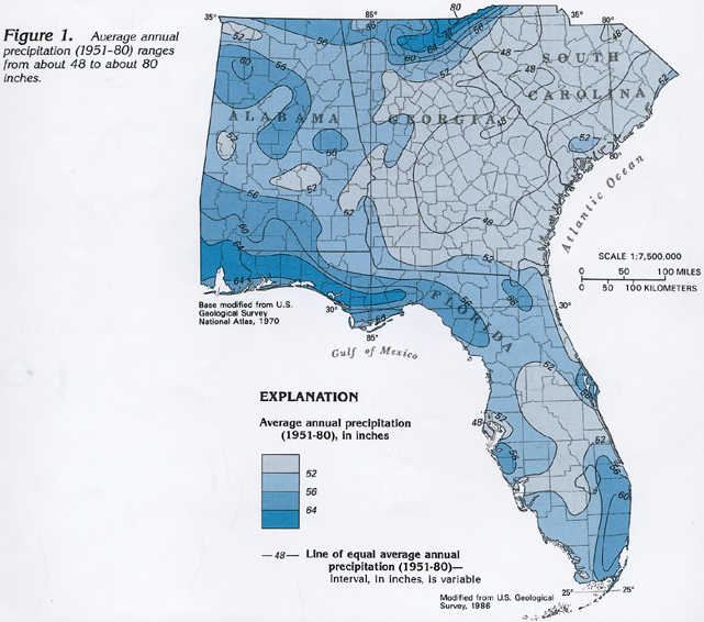
Precipitation is the source of all the water in the four States of Segment 6. Average annual precipitation (1951-80) ranges from about 48 inches per year over a large part of central South Carolina and Georgia to about 80 inches per year in mountainous areas of northeastern Georgia and western South Carolina. (fig. 1) In general, precipitation is greatest in the mountains (because of their orographic effect) and near the coast, where water vapor, which has been evaporated primarily from the ocean and the gulf, is picked up by prevailing winds and subsequently condenses and falls as precipitation when reaching the shoreline.
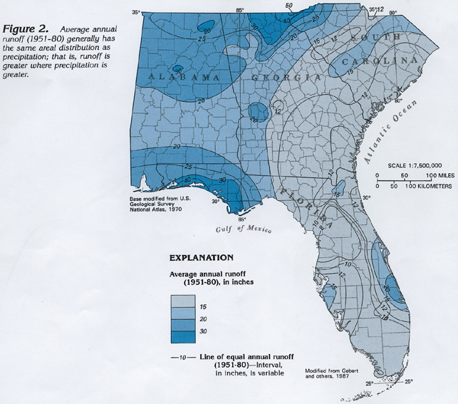
Much of the precipitation either flows directly into rivers and stream as overland runoff or indirectly as baseflow discharging from aquifers where the water has been stored for a short time. Accordingly, the areal distribution of average annual runoff from 1951 to 1980 (fig. 2) directly reflects that of average annual precipitation during the same period: runoff is greater in mountainous areas and near the coast. Average annual runoff in the four-State area ranges from about 8 inches per year in parts of north-central Florida to about 50 inches per year in the mountains of northeastern Georgia.
Comparison of the precipitation and runoff maps shows precipitation is greater than runoff everywhere in the four-State area. Much of the precipitation that falls on the area is returned to the atmosphere by evapotranspiration-evaporation from surface-water bodies, such as lakes and marshes, and transpiration from plants. However, a substantial part of the precipitation is available for aquifer recharge throughout the area.
MAJOR AQUIFERS
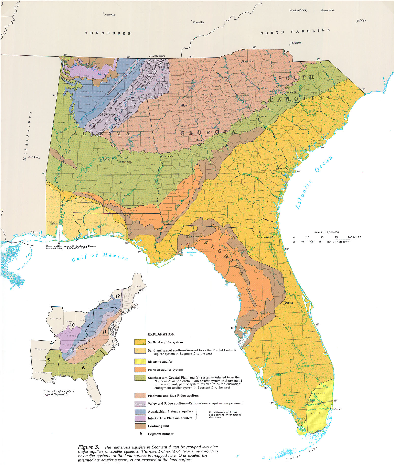
There are numerous aquifers in Segment 6, that range in composition from unconsolidated sand of the surficial aquifer system to hard, crystalline rocks of the Piedmont and Blue Ridge aquifers. These aquifers are grouped into nine major aquifers or aquifer systems on the basis of differences in their rock types and ground-water flow systems. An aquifer system consists of two or more aquifers that are hydraulically connected-that is, their flow systems function similarly, and a change in conditions in one aquifer affects the other aquifer(s).
The areas where eight major aquifers are exposed at land surface are shown in figure 3 (see opposite page). Many of these aquifers extend underground far beyond the limits of outcrop, and, accordingly, may be used for water supply in much larger areas than the size of their outcrop may indicate. In places, deeper aquifers that contain freshwater underlie the major aquifers mapped here. For example, in southeastern South Carolina, the surficial aquifer system shown on the map is underlain by the Floridan aquifer system, which in turn is underlain by the Southeastern Coastal Plain aquifer system, all of which contain mostly freshwater. In other places, such as the areas where aquifers of the Piedmont, Blue Ridge, Valley and Ridge, and Appalachian Plateaus physiographic provinces are mapped, deeper aquifers are nonexistent. In places in Alabama, Georgia, and Florida, a clayey confining unit that overlies the Floridan aquifer system is exposed at land surface, and wells need to be drilled through this clayey confining unit to penetrate the underlying aquifer.
The surficial aquifer system consists mostly of unconsolidated sand, but also contains a few beds of shell and limestone. The sand and gravel and Biscayne aquifers are separately recognized parts of the surficial aquifer system that consist of distinctive rock types. The sand and gravel aquifer consists of complexly interbedded lenses and layers of coarse sand and gravel, and the Biscayne aquifer consists predominantly of limestone. The intermediate aquifer system consists of sand and limestone and lies between the surficial aquifer system and the Floridan aquifer system. The intermediate aquifer system does not crop out, and, accordingly, is not shown on the map.
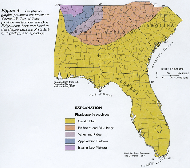
The Floridan aquifer system consists of limestone and dolomite, and is the most productive of the aquifers in the mapped area, in terms of total water yield. The Southeastern Coastal Plain aquifer system consists of four regional aquifers that are predominately sand, but these aquifers also contain some beds of gravel and limestone. All the aquifers from the surficial aquifer system down through the Southeastern Coastal Plain aquifer system are present in the Coastal Plain physiographic province (fig. 4). Water in all of the Coastal Plain aquifers is present primarily in intergranular pore spaces. However, solution openings in carbonate rocks of the Biscayne aquifer and Floridan aquifer system yield large volumes of water.
Piedmont and Blue Ridge aquifers consist of indurated metamorphic rocks, such as gneiss and schist, and igneous rocks, such as granite, that underlie the rolling hills of the Piedmont physiographic province and the mountains of the Blue Ridge physiographic province. Water is present in these rocks in fractures, but locally a large volume of water is stored in the regolith, or blanket of weathered material that overlies the rock.
Folded Paleozoic rocks underlie the Valley and Ridge physiographic province, and flatlying Paleozoic rocks underlie the combined Appalachian Plateaus and Interior Low Plateaus physiographic provinces. In these three provinces, the Paleozoic rocks consist of indurated sedimentary rocks; the major aquifers consist of limestone. However, the ground-water flow system is different where these rocks are folded and where they are not.
GEOLOGY
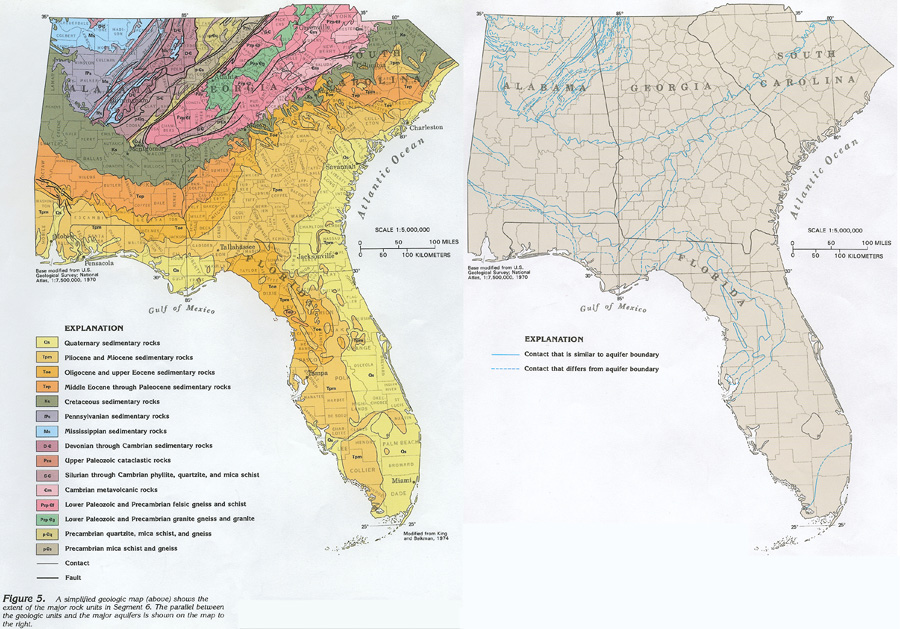
Two categories of sedimentary rocks comprise most of the rocks underlying the four States of Segment 6: well-indurated rocks of Paleozoic age and poorly indurated to unconsolidated rocks of Cretaceous age and younger. The Paleozoic sedimentary rocks crop out in northern Alabama and northwestern Georgia; whereas, the Cretaceous and younger rocks underlie the Coastal Plain and form a broad, arcuate, coast-parallel band. Both categories have been divided into numerous formations, as shown on correlation charts in the discussions of the major aquifers in following sections of this chapter.
The majority of the water-yielding Paleozoic rocks are limestone; however, some water also is obtained from sandstone and, locally, from chert beds and fractured shale.
Most Coastal Plain strata are clastic rocks; however, the carbonate rocks of the Floridan aquifer system also are important. Triassic, Jurassic, and Lower Cretaceous rocks are present only in the deep subsurface of the Coastal Plain and do not form aquifers except in a local area in Alabama where Lower Cretaceous rocks form a small part of the Southeastern Coastal Plain aquifer system.
The geologic map (fig. 5) shows the distribution of rocks by major age category and also shows that an extensive area is underlain by crystalline rocks. These are metamorphic and igneous rocks that crop out in a broad, northeast-trending band that widens from eastern Alabama into eastern Georgia and western South Carolina. The crystalline rocks are hard, and generally are more resistant to weathering and erosion than sedimentary rocks. The gently rolling hills of the Piedmont physiographic province and the rugged mountains of the Blue Ridge physiographic province were formed as a result of these crystalline-rock characteristics. Radiometric dating of the crystalline rocks has determined that they range in age from late Precambrian to Permian. Locally, they have been intruded by diabase dikes of Late Triassic to Early Jurassic age. Detailed mapping shows that the crystalline rocks are complex; for example, they have been separated into about 90 units on the 1976 geologic map of Georgia. Because the crystalline rocks have similar hydraulic characteristics, they are mapped and discussed as a single aquifer.
Several major faults are shown in figure 5. Some of these faults form boundaries between major rock categories; for example, a fault marks the contact between metamorphic rocks of the Blue Ridge physiographic province and tightly folded Paleozoic rocks of the Valley and Ridge physiographic province.
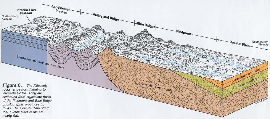
The area mapped in figure 5 can be divided into four broad categories of geologic structure. From northwest to southeast, these are: (1) flatlying Paleozoic sedimentary rocks that underlie the combined Appalachian Plateaus and Interior Low Plateaus physiographic provinces; (2) the same rocks folded into a series of anticlines and synclines in the Valley and Ridge physiographic province, where resistant rocks form the ridges and soft rocks underlie the valleys; (3) intensely deformed metamorphic rocks of the Piedmont and Blue Ridge physiographic provinces that have been intruded by small to large bodies of igneous rocks; and (4) gently dipping, poorly consolidated to unconsolidated sediments of the Coastal Plain physiographic province. The block diagram in figure 6 shows the general relations of the four major categories. The combination of rock type and geologic structure largely determines the hydraulic character of the rocks. These factors, plus topography and climate, determine the characteristics of the ground-water flow system throughout the mapped area.
VERTICAL SEQUENCE OF AQUIFERS
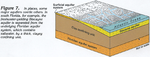
Some of the major aquifers and aquifer systems in Segment 6 lie atop others. For example, the Biscayne aquifer in southern Florida overlies the Floridan aquifer system, but the two are separated by a thick, clayey confining unit (fig. 7). Water is able to move vertically between some of these aquifers. Movement is in the direction of decreasing hydraulic head, and occurs most easily where the confining units separating the aquifers are absent, thin, or leaky.
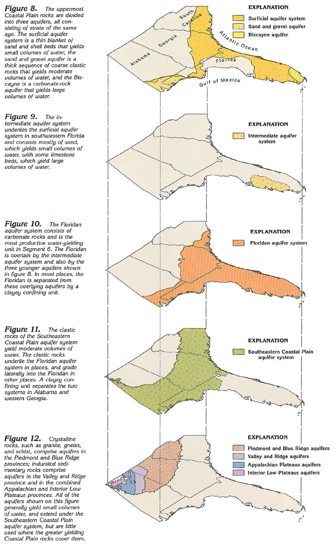
The sequence of maps on this page shows the extent of each aquifer or aquifer system. Comparison of the maps shows the places where aquifers are stacked upon each other. The three uppermost aquifers in the Coastal Plain are shown in figure 8. These aquifers, the surficial aquifer system, sand and gravel aquifer, and Biscayne aquifer are all the same geologic age (primarily Pleistocene and younger), and all contain water mostly under unconfined (water table) conditions. However, even though these aquifers are lateral equivalents, the lithology and permeability of each are different. The surficial aquifer system is a thin, widespread layer of unconsolidated sand beds that commonly contains a few beds of shell and limestone. This aquifer system generally yields small volumes of water, and primarily is used for domestic supplies. The sand and gravel aquifer consists largely of interbedded layers of coarse sand and gravel that were deposited by streams. Thin clay beds in this aquifer locally create semiconfined conditions. The sand and gravel aquifer yields moderate volumes of water, and is an important source of supply for several counties in westernmost panhandle Florida and southwestern Alabama. Westward, in Mississippi, the sand and gravel aquifer grades into the Coastal lowlands aquifer system. The Biscayne aquifer, the source of water supply for several large cities along the southeastern coast of Florida, is a highly permeable sequence of mostly carbonate rocks that were deposited in marine waters.
The intermediate aquifer system (fig. 9) underlies the surficial aquifer system and overlies the Floridan aquifer system. The intermediate aquifer system is bounded above and below by clayey confining units. The system is not exposed at land surface and is recharged primarily by downward leakage from overlying aquifers. Sand beds and limestone lenses comprise the permeable parts of the system. The intermediate aquifer system is an important source of municipal supply in Sarasota, Charlotte, and Glades Counties, Fla.; elsewhere, it primarily is used for domestic supplies.
The Floridan aquifer system (fig. 10) consists of a thick sequence of carbonate rocks and is the most productive aquifer in Segment 6. The Floridan underlies the intermediate aquifer system where the latter is present; it also underlies the surficial aquifer system, the sand and gravel aquifer, and the Biscayne aquifer, but is separated from them practically everywhere by a thick, clayey confining unit. Where the surficial aquifer system overlies the Floridan, the clayey confining unit between the systems is thick in some places and thin or absent in other places. The Floridan supplied more than 3 billion gallons of water per day during 1985, primarily for municipal and agricultural purposes.
The Southeastern Coastal Plain aquifer system (fig. 11) underlies the Floridan aquifer system in some places (mostly in western Georgia and westward) and grades laterally into the Floridan in other places (mostly in southeastern Georgia and southwestern South Carolina). The upper part of the Southeastern Coastal Plain aquifer system grades laterally into the Mississippi embayment aquifer system in western Alabama (fig. 3). The Southeastern Coastal Plain aquifer system consists of four regional aquifers that are primarily sand beds, but which contain some gravel and limestone. The four regional aquifers generally yield large volumes of water in updip areas, where they are mostly sand, but the aquifers are less permeable in a coastward direction due to increasing clay content toward the coast. The system is an important source of water supply for all purposes throughout the inner part of the Coastal Plain.
Although rocks of the Piedmont, Blue Ridge, Valley and Ridge, and the combined Appalachian Plateaus and Interior Low Plateaus physiographic provinces (fig. 12) extend under the Southeastern Coastal Plain aquifer system, these rocks generally are not used as aquifers there because water can be more readily obtained from the shallower, unconsolidated Coastal Plain sediments. Piedmont and Blue Ridge aquifers consist of a complex sequence of metamorphic and igneous rocks, and primarily supply domestic or agricultural wells. Well yields generally are small; the water is obtained from fractures in the unweathered crystalline rock and from the mantle of regolith (weathered materials, soil, and alluvium) that overlies it. Major fault systems separate the Piedmont and Blue Ridge aquifers from the Valley and Ridge aquifers to the northwest.
The Valley and Ridge and the combined Appalachian Plateaus and Interior Low Plateaus aquifers consist of indurated sedimentary rocks of Paleozoic age. Water is obtained primarily from limestone in these provinces and secondarily from sandstone, chert beds, or fractured shale. In the Valley and Ridge province, these sedimentary rocks have been tightly folded into a sequence of northeast-trending anticlines and synclines that have been displaced by thrust faults in many places. Ground-water circulation extends to greater depths in these folded rocks than in the Appalachian Plateaus and Interior Low Plateaus provinces to the northwest where the same rocks are almost flatlying. In the Appalachian Plateaus province, the flatlying beds are topped with a resistant cap of sandstone; in the Interior Low Plateaus province, the sandstone has been dissected by erosion, and underlying limestone beds are exposed. The contact between the Valley and Ridge and Appalachian Plateaus provinces is distinct in some places where it follows faults and is gradational from nearly horizontal strata to folds in other places.
FRESH GROUND-WATER WITHDRAWALS
Ground water is the source of water supply for almost 11 million people, or about 73 percent of the population in the four-State area.
About 5,600 million gallons per day was withdrawn from all the principal aquifers during 1985; 46 percent was used in rural areas for domestic and commercial supplies and for agricultural supplies. Withdrawals for public supply were somewhat less, accounting for 35 percent of the total water withdrawn.
Total withdrawals of fresh ground water, by county, are shown in figure 13. Counties with the largest withdrawals are those that have large population centers except for south-central Florida, where combined agricultural and mining uses account for most of the withdrawals. Fresh ground-water withdrawals for most water use categories are increasing, according to a recent (1990) nationwide compilation of water-use data by the U.S. Geological Survey.
Total withdrawals of freshwater during 1985 from each of the principal aquifers in the four-State area are shown in figure 14. About 3,181 million gallons per day was withdrawn from the Floridan aquifer system, almost four times as much water as was withdrawn from the second most used aquifer, the Biscayne aquifer (786 million gallons per day), and almost twice as much water as was withdrawn from all the other principal aquifers combined. More water was withdrawn from the Biscayne aquifer, although it only extends throughout a small area in the southeastern tip of Florida, than from either the Southeastern Coastal Plain aquifer system (574 million gallons per day) or the surficial aquifer system (361 million gallons per day), even though both have a much larger areal extent. This is because the Biscayne is the source of supply for several large cities, including Miami, West Palm Beach, and Fort Lauderdale, along the southeast coast of Florida. About 298 million gallons per day was withdrawn from the intermediate aquifer system, about 150 million gallons per day from the sand and gravel aquifer, and about 149 million gallons per day from the combined Valley and Ridge, Appalachian Plateaus, and Interior Low Plateaus aquifers. Only about 100 million gallons per day, or about 2 percent of the total freshwater withdrawn, was obtained from the Piedmont and Blue Ridge aquifers because surface water is the primary source of supply in the area underlain by these aquifers.