INTRODUCTION
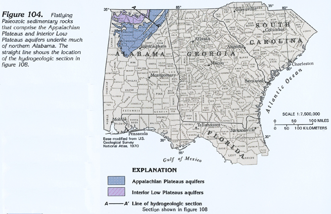
Aquifers in the Appalachian Plateaus and Interior Low Plateaus physiographic provinces consist of permeable stratigraphic units within flatlying sedimentary rocks of Paleozoic age. The extent of these aquifers, which are treated together in Segment 6, is shown in figure 104. These aquifers underlie most of the area in Segment 10 of this Atlas, and, accordingly, are not discussed in great detail here. Both the Appalachian Plateaus and Interior Low Plateaus are extensive tablelands; underlying rocks are either flat or dip at angles of only a few degrees. The Appalachian Plateaus are flat areas of undissected plateau that lie at high altitudes and are capped by resistant sandstone. These high areas resemble large mesas and are bounded by steep-faced slopes. In the Interior Low Plateaus province, erosion has removed part or all of the resistant sandstone cap, exposing underlying limestone at the surface.
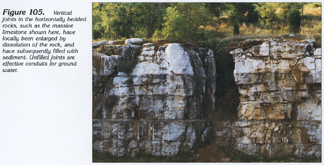
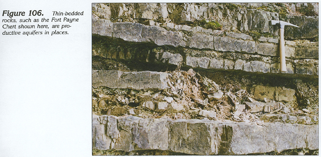
The major aquifers in both physiographic provinces are in limestone units of Mississippian age that are exposed in wide valley floors in the Interior Low Plateaus province and are covered, in the Appalachian Plateau areas, by clastic rocks of Pennsylvanian age. Where they are uneroded, Pennsylvanian sandstone units supply sufficient water for domestic use. Most of the water in both limestone and sandstone is present in fractures. In the limestone, the circulation of slightly acidic ground water has enlarged these fractures by dissolution of the carbonate rock. Where vertical fractures extend to the land surface, the enlarged solution conduits may become completely or partially filled with sediment transported into them by surface streams (fig. 105). Where they are unfilled, solution openings convey large volumes of water. Thin-bedded, siliceous limestone and chert of the Fort Payne Chert of Mississippian age (fig. 106) also constitutes a productive aquifer in the Appalachian Plateaus physiographic province. The Fort Payne has been intensely fractured, thus increasing the volume of water it can transmit.
HYDROGEOLOGIC UNITS
Rocks comprising the Appalachian Plateaus and Interior Low Plateaus aquifers in Alabama and Georgia are mostly limestone, sandstone, and shale, but also include beds of siltstone, conglomerate, dolomite, and chert. They range in age from Devonian to Pennsylvanian (fig. 107). Most of the formations are continuous from Alabama into extreme northwestern Georgia. Many of these formations extend into the Valley and Ridge physiographic province, where they are folded. The rocks have little variation in lithology throughout northern Alabama and northwestern Georgia, and the permeability characteristics of the rocks are, accordingly, uniform. Like the Valley and Ridge aquifers, boundaries of geologic formations and aquifers in the Appalachian Plateaus and Interior Low Plateaus physiographic provinces are considered to be the same, and, therefore, no aquifers are formally named; rather, the hydrologic characteristics of individual geologic formations are discussed.
Most of the Appalachian Plateaus aquifers identified in figure 107 are limestone units, which are productive aquifers because of the solution openings that develop in the soluble carbonate rocks. For example, wells completed in the Bangor Limestone yield as much as 200 gallons per minute, and springs issuing from the Bangor have reported flows of as much as 4,000 gallons per minute. The Tuscumbia Limestone, combined with the Fort Payne Chert to which it is hydraulically connected, yields as much as 2,300 gallons per minute to wells. The Monteagle Limestone generally yields only small volumes of water.
Sandstone beds of the Pottsville Formation yield small volumes of water, but the Pottsville supplies water to a large number of domestic wells because it caps thousands of square miles of upland plateaus. Sandstone of the Parkwood Formation yields water to only a few scattered domestic wells. Water in the sandstone is obtained primarily from fractures.
Erosion of the flatlying rocks of the Appalachian Plateaus physiographic province has produced isolated, sandstone-capped hills that rise several hundred feet above easily eroded limestone beds exposed in the Interior Low Plateaus province. A thick black shale (the Chattanooga Shale) forms an effective basal confining unit for the ground-water flow system in the Appalachian Plateaus aquifers. A thick sequence of permeable rocks, primarily limestone of Devonian to Cambrian age, underlies the Chattanooga Shale. However, the deeper beds seldom are used for water supplies because of the expense of constructing deep wells and because many of these beds contain brackish or saltwater. In the northern part of Limestone County, Ala., the Chickamauga Limestone of Ordovician age is exposed along a few stream valleys and yields water to domestic wells. Except for this localized situation, the Chattanooga Shale can be considered to represent the base of the ground-water flow system.
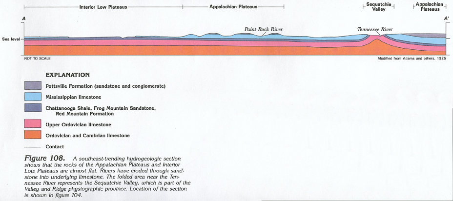
The folded area near the right end of figure 108 is the Sequatchie Valley that is part of the Valley and Ridge physiographic province. Another area of flatlying rocks of the Appalachian Plateaus physiographic province extends to the southeast of this valley. The axis of the valley is occupied, in part, by the Tennessee River.
GROUND-WATER FLOW
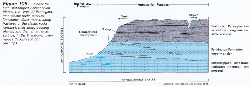
Flow in the Appalachian Plateaus and Interior Low Plateaus aquifers is affected primarily by topography, structure, and the development of solution openings in the rocks. The effect of topography is shown in figure 109. A thick sequence of shale, sandstone, and coal overlies Mississippian limestone. Recharge to the aquifers is by precipitation on the flat, mesa-like plateau tops. The water then percolates downward through the interbedded Pennsylvanian rocks, primarily along steeply inclined joints and fractures. In places, shale beds retard the vertical flow and some of the water is shunted laterally along bedding planes, mostly in sandstone and conglomerate beds, until it emerges as springflow along steep valley walls, such as the Cumberland escarpment. Some of the water is able to leak downward across the thick shale confining unit into the underlying limestone aquifer.
Circulation of water in the limestone underlying the Appalachian plateaus is not as vigorous as that in places where erosion has exposed the carbonate rocks in the Interior Low Plateaus. As shown in figure 109, solution openings in limestone under the Appalachian plateaus are developed primarily along the bases of the escarpments and do not extend far under the shale and sandstone. Water-quality data, however, indicate that circulation has been sufficient to allow freshwater to displace saltwater from the limestone in most places.
Where erosion has removed the clastic Pennsylvanian and Upper Mississippian rocks, the flow pattern is different. Limestone underlying wide stream valleys in lowland areas of the Interior Low Plateaus is overlain only by a mantle of residuum. Recharge is principally from precipitation on the valley floor, and the water percolates quickly downward through the residuum into the underlying limestone. Karst topography commonly develops on the valley floors, especially where the cover of residuum is thin. Ground water does not usually circulate to great depths in this type of geologic setting.
GROUND-WATER AVAILABILITY
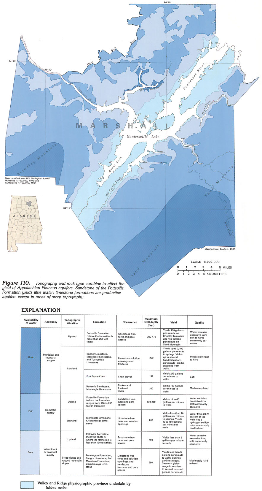
The lithology of the rocks comprising the aquifers and the topography developed on them are the two major factors that determine the yield of Appalachian Plateaus and Interior Low Plateaus aquifers. The availability of ground water in Marshall County, Ala., is shown in figure 110. The southeastern one-third and the northwestern one-half of Marshall County are underlain by flat rocks that comprise part of the Appalachian Plateaus aquifers.
Areas where aquifers yield large, moderate, and small volumes of water are shown in figure 110. Volumes of water sufficient for some municipal and industrial supplies can be obtained readily from limestone formations and the Fort Payne Chert where these formations are exposed in broad lowlands. Domestic supplies can be obtained from limestone formations in any lowland area. Some limestone formations, where they crop out on the faces of steep ridges, yield little water. Sandstone of the Pottsville Formation varies greatly in its water-producing capabilities. Yield of the Pottsville is affected more by thickness, extent of fracturing, and depth of weathering than by topographic position, because the Pottsville is always a plateau-capping formation in upland areas.
Data in the table adjacent to figure 110 indicate that most of the water in both limestone and sandstone units is present in fractures and solution openings. A small volume of water can be obtained from the intergranular pore spaces in the sandstone, but these spaces mostly are filled with cement of iron oxide, silica, or clayey material. In Marshall County, springs issue only from the limestone formations.
GROUND-WATER QUALITY
The quality of the water in the Appalachian Plateaus and Interior Low Plateaus aquifers is variable, but most of the water is suitable for most uses, although concentrations of sulfate and iron are objectionable in places. Large concentrations of hydrogen sulfide, derived from sulfate, can impart a "rotten-egg" odor to the water. Large concentrations of iron cause staining of plumbing fixtures. The quality of the water generally deteriorates with depth as it becomes more mineralized. In places, dissolved-solids concentrations at depths of 300 feet or more in limestone aquifers are as large as 1,000 milligrams per liter.
Water in the sandstone of the Pottsville Formation and the underlying Mississippian limestone aquifers is chemically similar (fig. 111). Water from the Pottsville is a calcium magnesium bicarbonate type and water from the Mississippian limestone aquifers is a calcium bicarbonate type. Sodium and potassium concentrations are greater in water from the sandstone because of its shale, feldspar, and mica content, than in the water from the limestone. Iron concentrations generally are greater in water from the sandstone whereas sulfate and chloride concentrations generally are greater in water from the limestone. Chloride concentrations, generally less than 250 milligrams per liter, vary from formation to formation.