INTRODUCTION
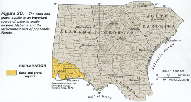
The sand and gravel aquifer underlies an area of about 6,500 square miles in southwestern Alabama and the westernmost part of panhandle Florida (fig. 20). The aquifer is presently (1990) called the Miocene-Pliocene aquifer in Alabama; in the past, it has been called the Citronelle or Citronelle-Miocene aquifer in that State by some authors. In Mississippi, the sand and gravel aquifer grades laterally into part of the Coastal lowlands aquifer system that extends westward into southern Texas. The sand and gravel aquifer is the primary source of water in Baldwin, Washington, and western Escambia Counties, Ala., and in Santa Rosa and Escambia Counties, Fla. The aquifer also supplies most of the water used by small communities in the rural parts of Mobile County, Ala.; the city of Mobile in that county, however, is supplied by surface water. About 150 million gallons per day was withdrawn from the sand and gravel aquifer for all uses during 1985. About 80 percent was withdrawn in the Pensacola, Fla. area, and the majority of the remaining 20 percent was withdrawn in Mobile County, Ala.
As its name indicates, the sand and gravel aquifer consists largely of interbedded layers of sand and gravel. Clay beds and lenses are common in the aquifer and form local confining beds. Water in the aquifer is under unconfined conditions where the clay beds are thin or absent, and is under artesian conditions where such beds are thick. Movement of ground water is generally coastward.
GEOLOGY
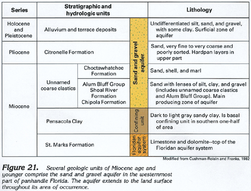
The sand and gravel aquifer consists of rocks ranging in age from middle Miocene to Holocene that were mostly deposited in a deltaic environment. In Alabama, Miocene rocks are all included in the undifferentiated Catahoula Sandstone, a thick, predominantly nonmarine sequence of sand and clay beds. The Miocene units shown in figure 21 are overlain by the Citronelle Formation of Pliocene age. The Citronelle is mostly fine- to coarse-grained sand that is locally gravelly, and is the most important water-yielding formation in the upper part of the sand and gravel aquifer. The Citronelle locally contains layers of hardpan, or cemented iron oxide, that retard ground-water movement. The principal geologic units that comprise the aquifer in the westernmost part of the Florida panhandle are shown in figure 21. The Alum Bluff Group and the Choctawatchee Formation, which were deposited in a more marine environment, are most easily recognizable near the coast. Northward, these beds grade into undifferentiated coarse sand and gravel, which comprise the major water-yielding unit of the lower part of the sand and gravel aquifer.
THICKNESS
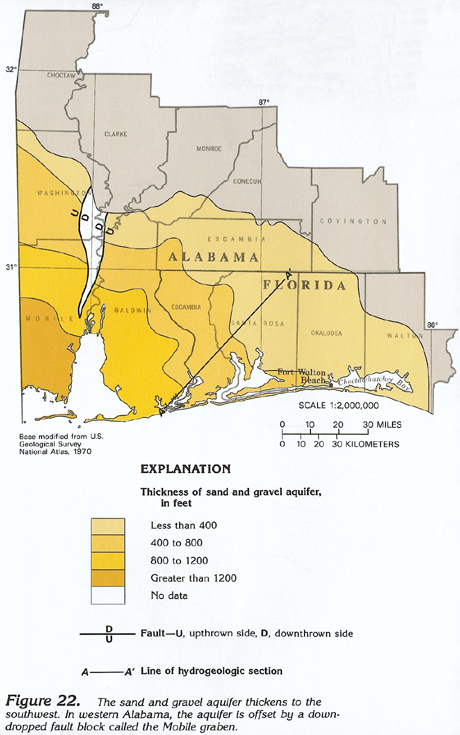
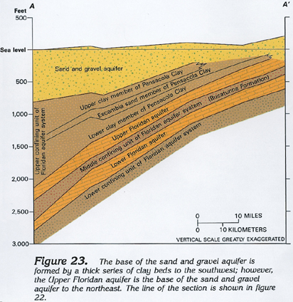
The sand and gravel aquifer is approximately wedge-shaped and thickens southwestward from a feather edge at its northern and eastern limit to about 1,400 feet in southwestern Alabama (fig. 22). Throughout the southern two-thirds of the area underlain by the aquifer, the confining unit forming the base of the aquifer consists of either the upper or lower clay members of the Pensacola Clay (fig. 23). Analysis of aquifer-test data, supplemented by the results of laboratory testing of cores from the Pensacola Clay, indicates that the permeability of this confining unit is so small that practically no water passes across it. To the northeast, the clay beds are absent and the sand and gravel aquifer is in direct contact with the Upper Floridan aquifer.
HYDROGEOLOGIC UNITS
In most places, the sand and gravel aquifer can be divided into two high-permeability zones, the upper surficial and lower main producing zones, separated by a less permeable sand and clay unit. The upper, or surficial, zone is mostly fine- to medium-grained sand, with gravel beds and lenses, and contains water that is mostly under unconfined conditions. This zone is recharged directly by precipitation, and ground-water flow in it is mostly lateral along short flowpaths to discharge points along small streams. Some of the water percolates downward and recharges the lower high-permeability zone. The upper zone consists mostly of the Citronelle Formation combined with stream-valley alluvium and terrace deposits. Along major streams, such as the Mobile River, alluvial deposits are as much as 150 feet thick and wells completed in them yield as much as 850 gallons per minute. The upper zone contains clay and hardpan layers that create local perched water tables or, in places, artesian conditions. The upper zone is mostly used for water supply in southern Mobile, southern Baldwin, and southwestern Escambia Counties, Ala., because the lower zone contains much clay in these counties, and, accordingly, yields less water. The hydraulic characteristics of the upper zone are extremely variable. Yields of as much as 1,000 gallons per minute are reported for wells completed in the upper zone, and a transmissivity of 11,000 feet squared per day was reported for the zone based on results of an aquifer test conducted in Escambia County, Ala.
In the westernmost part of panhandle Florida, the lower of the two high-permeability zones is called the "main producing zone" because most of the ground water used in Santa Rosa and Escambia Counties is withdrawn from this zone. This zone also is the main source of water supply for Washington, northern Mobile, northern Baldwin, and eastern Escambia Counties, Ala. The zone consists mostly of coarse sand and gravel beds, all of Miocene age. Water in this zone is confined everywhere. Recharge to the zone is by downward leakage from the upper zone; discharge is to major streams, bays, sounds, and the Gulf of Mexico. Yields of more than 1,000 gallons per minute are commonly reported for wells completed in this zone, and results of aquifer tests have indicated that the transmissivity of the zone is as much as 20,000 feet squared per day.
GROUND-WATER FLOW
Water enters the sand and gravel aquifer as recharge from precipitation, and moves generally downward and then either discharges to streams or moves coastward in the aquifer. Discharge is primarily to streams, bays, and sounds. Small volumes of water leak upward to the Gulf of Mexico and still smaller volumes are discharged by wells. Most of the well discharge is in Mobile County, Ala., and Escambia and Santa Rosa Counties, Fla.
Water movement in the upper zone of the aquifer is complex because this zone contains numerous discontinuous clay layers and some layers of iron oxide (hardpan). Because of the low permeability of the hardpan and the clay, and the confined conditions they produce, perched water-table conditions, artesian conditions, and true water-table conditions can all exist in one area. Such conditions prohibit drawing a representative map of the potentiometric surface of the aquifer, except for local areas. Where hardpan or clay beds are near the land surface, ponds may be perched on them or springs may issue at the top of such beds where they are exposed in small stream valleys. Some water percolates downward across all these confining beds to recharge deeper permeable zones in the aquifer. Water levels generally decrease with depth in the aquifer, a condition that allows downward leakage almost everywhere.
The saturated thickness of the aquifer is everywhere less than its total thickness because the water table ranges from a few feet to about 50 feet below land surface. The water table is just below land surface in low-lying areas and is deepest under hills and ridges.
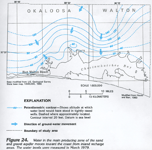
The general coastward movement of water in the main producing zone of the sand and gravel aquifer is shown by the potentiometric contours in figure 24. The arrows show that the water is moving mostly toward Choctawatchee Bay from recharge areas where water levels are highest. The contours are smooth and evenly spaced because the water in this zone is confined. A similar map for the surficial zone of the aquifer would show the same general seaward movement of water, but the contours would be convoluted because of the effects of topography and streams.
GROUND-WATER QUALITY
Water in the sand and gravel aquifer is suitable for drinking practically everywhere. The quartz-rich sediments that comprise the aquifer are practically insoluble; accordingly, water in the aquifer has concentrations of dissolved solids that ordinarily are less than 50 milligrams per liter. Chloride concentrations also are ordinarily less than 50 milligrams per liter everywhere except in a few locations near the coast and adjacent to large bays and sounds where there is a transition zone of freshwater and saltwater; there, chloride concentrations greater than 1,000 milligrams per liter are reported in water from some wells. Water in the aquifer is usually slightly acidic, with a pH of about 6.0; locally, the water is more acidic (pH 4.5). Dissolved-iron concentrations may locally be objectionable; concentrations as large as 4,300 micrograms per liter have been reported.
The sand and gravel aquifer, like other shallow aquifers, is readily susceptible to contamination. Contamination of the upper zone has occurred at several places in the three westernmost counties of Florida. One such place is a site near Pensacola where creosote waste products from a wood-preserving plant have been detected in a large part of the upper zone of the aquifer.
FRESH GROUND-WATER WITHDRAWALS
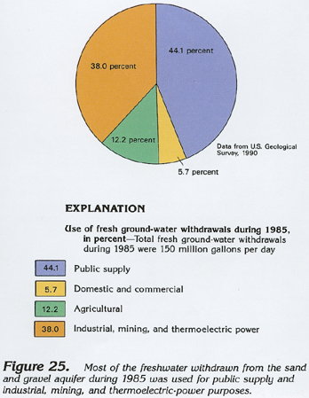
Withdrawals of freshwater from the sand and gravel aquifer totaled 150 million gallons per day during 1985. About 44 percent, or about 66 million gallons per day, was withdrawn for public supply (fig. 25). About 9 million gallons per day was withdrawn for domestic and commercial uses, and about 18 million gallons per day was withdrawn for agricultural uses. About 57 million gallons per day was withdrawn for industrial, mining, and thermoelectric-power uses.